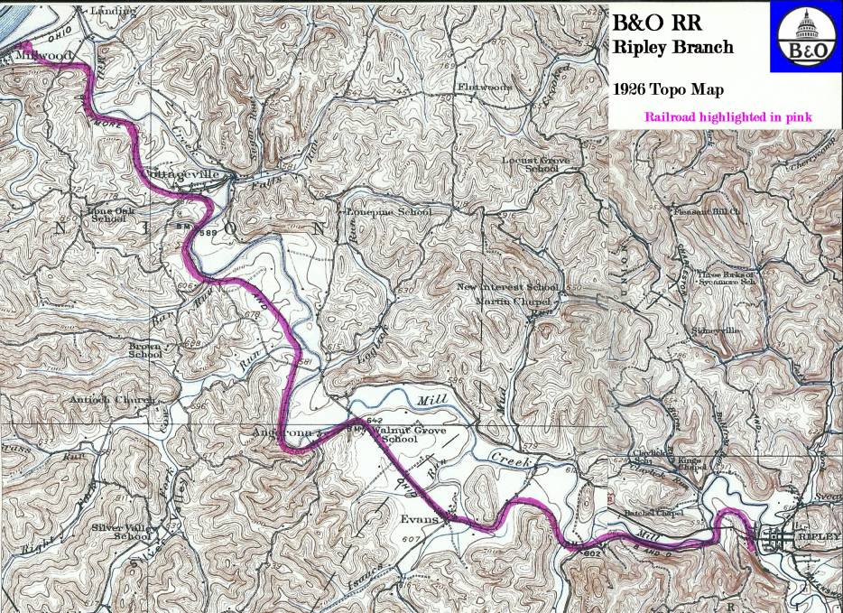
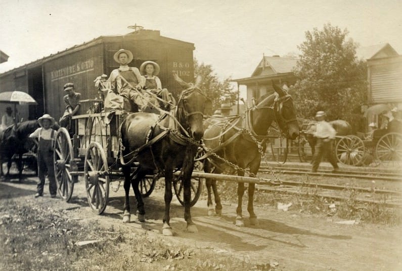
B&O Ripley Branch-Millwood to Ripley
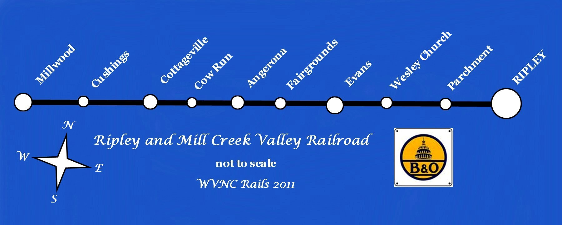
Custom map of the Ripley and Mill Creek Valley Railroad/ B&O Railroad Millwood to Ripley Branch depicting the small towns and hamlets which the railroad served.
Overview
There are rail lines that spark the interest in one form or another but the B&O Ripley Branch that ran from Millwood to Ripley goes beyond simply being a casual one. With family roots entrenched deep in Jackson County, this small line was a personal one as well. For family tree branches, Robie from the Ripley and Evans area, along with Hannum on my mother’s side at Millwood and Mt. Alto, this line was a pipeline in a simpler world. Before the proliferation of automobiles and the paving of roads, this small rail line was the gateway to Ripley for local passengers and commerce as well as a connection to the outside world of Wheeling and Huntington or beyond. Like numerous area residents of that bygone era, both my parents and grandparents rode many a train beside the creek ridges and through the meadows along Mill Creek.

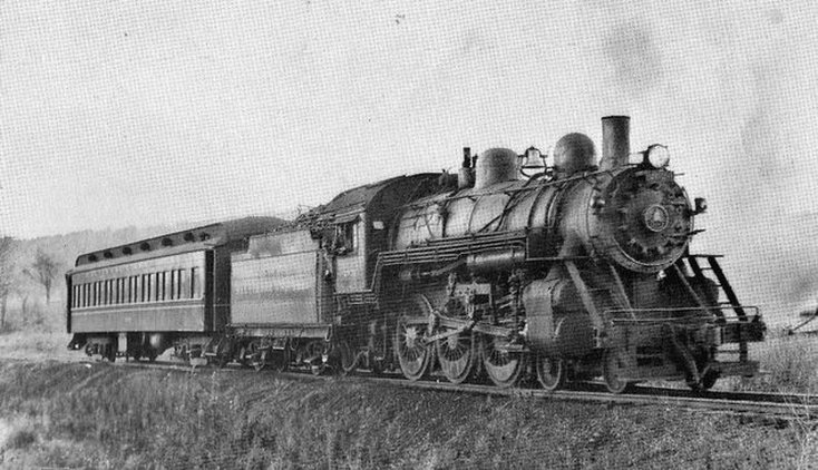
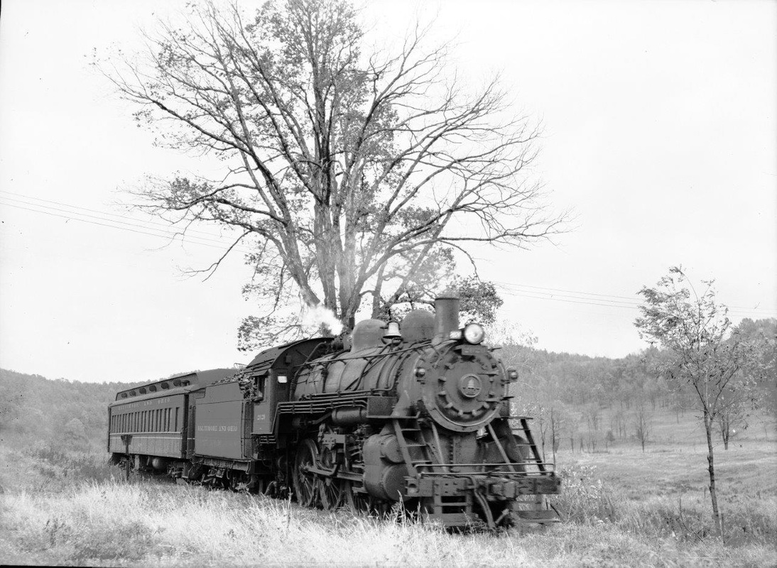
B&O 4-6-0 "Ten-Wheeler" #2028 and crew at Ravenswood, WV circa 1950. Both this locomotive and crew worked the B&O branch lines to Ripley and Spencer during the final years of steam. Image Richard J. Cook/John G. King/Dan Robie collection
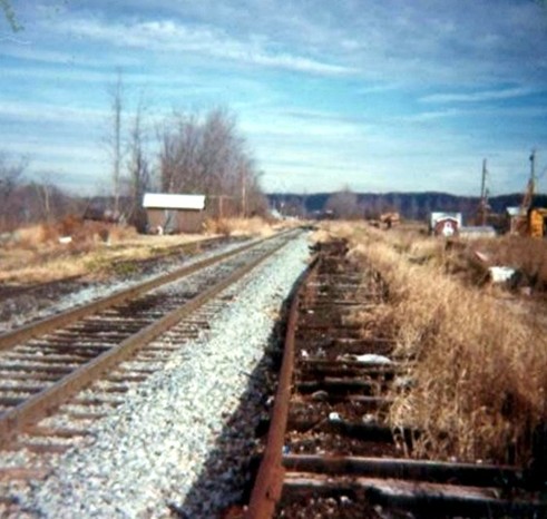
Researching the history of this rail line is difficult. The track has been gone for many years and the right of way has been altered or has outright disappeared at various locations. There is sporadic remaining evidence of the railroad's existence and to say there is scant recorded history would be an understatement. Finally, the passing of the years has reduced the number of individuals who could recite firsthand accounts of this railroad in operation. I have knowledge shared by my father about his recollections of operations along the line but little else. Period photographs are extremely rare although included will be a few archival images I have been graciously permitted to use along with contemporary ones of my own.
Unfortunately, during my recent quest of taking photos, the weather was uncooperative resulting in lesser quality images and there are areas I did not visit such as the Cow Run region being most noteworthy. There are also sections along the right of way that are virtually inaccessible due to heavy brush growth or that would incite trespassing. My intent is to revisit the area and attempt to fill in the blanks so to speak that will not be covered in this initial posting (2011) of the work. I hope to obtain permission from landowners in the future to grant me access to photograph the right of way in areas thus far not done to enhance the content of this effort.
To my knowledge, there has been little dedicated documentation of the Ripley Branch. If it does or did exist, it has been lost to time. If any reader has any knowledge of interested individuals who might possess photographs or accounts of this line to share here, I would be most grateful. Any future information or images can be spliced into this piece with all due credits. While in no shape or form is this a definitive account here, it is at least a meager attempt to shed insight on this piece of Jackson County and family history. Moreover, it is my sincere intent to be as accurate as possible with the material posted here and if the reader discovers an error or can better clarify any information, please contact me by the Visitor Feedback page on this website.
This humble effort is dedicated to the memory of my parents, S.E. and Mildred Robie.
This humble effort is dedicated to the memory of my parents, S.E. and Mildred Robie.
Originally the Ripley and Mill Creek Valley, the 12.3 mile line ultimately was absorbed into the Baltimore and Ohio Railroad in 1901. The route paralleled the Mill Creek basin between Millwood and Ripley.
History
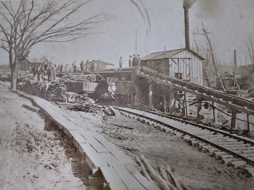
The late 19th century spawned ambitious visionaries that knew a railroad was instrumental for developing either wealth or community commerce. It is no coincidence that in seeking to expand Ripley and Jackson County with improved access that a number of such citizens looked to the building of a railroad to accomplish this. The Ohio River Railroad between Wheeling and Kenova was under construction during the mid 1880s and once completed to Millwood, a connecting line to Ripley was a feasible and practical undertaking. The first recipient awaiting benefit from the new railroad was the timber industry of the region scattered along the Mill Creek watershed.
During 1884, W.T Greer, John Greer, Kenna Hood, and Jim Poling along with other citizens of Jackson County formed a stock company and the County Court donated a $25,000 bond to the building of a railroad. A charter was subsequently granted under the name of Ripley and Mill Creek Valley Railroad of which the line would be known. In early 1885, the right of way was acquired for the building of a 12.3 mile route connecting Millwood to Ripley and serving the small communities between. In a gesture that would be unheard of today, virtually all the necessary right of way tract was donated by landowners along the route owning to the importance and enthusiasm of its construction. In addition, the Ohio River Railroad--which stood to profit from this new railroad---guaranteed $50,000 worth of R&MCV bonds. There is evidence from an 1887 letter written by W. T. Greer inquiring about equipment that the Ripley & Mill Creek Valley Railroad considered building as a three-foot narrow gauge. This idea was undoubtedly nixed when an agreement with the Ohio River Railroad stipulated the use of its crews and motive power on the line. If three-foot gauge was indeed constructed initially, its existence would have been brief.
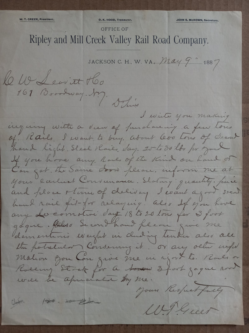
A May 9,1887 letter written by R&MCV RR president W. T. Greer inquiring about the purchase of light rail and a locomotive. This document indicates that there was interest in building the railroad as a three-foot narrow gauge line but this plan was shelved with the impending Ohio River Railroad involvement. Letter image contributed by Scott M. Greathouse
Despite its short length, the R&MCV presented challenges during construction. This was an era when strenuous manual labor was the method of building a railroad. Horses and oxen were used to grade the right of way along with manpower for the actual track laying. Throughout the route, thirteen trestles were constructed averaging one per mile and these varied in length and height. Tight curvatures were common along the route with the worst at twenty degrees located at Cushings. The only appreciable tangent was the straight shot through Evans which was a respite for Millwood bound trains making a run for the climb at Angerona, the steepest of the gradients the line traversed. Also, a careful study of the right of way will reveal that although the route roughly paralleled Mill Creek in its entirety, construction avoided its vulnerable flood plain where possible.
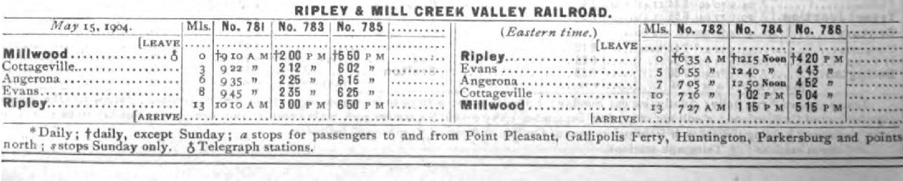
The importance of the railroad to Ripley in its early years is demonstrated on this 1904 timetable. Three scheduled passenger trains traversed the route with a likewise number returning to Millwood.
R&MCV Stock
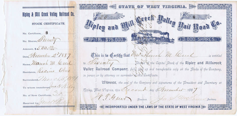
Two rare piece of memorabilia. Original Ripley and Mill Creek Valley stock certificate for $500 paid towards twenty shares dated November 2, 1887. My gratitude to Rhod Mills Rails'N'Relics for the scan and use of this image.
Below left: An 1893 railroad pass issued by the Ripley and Mill Creek Valley Railroad. Image Jackson County Historical Society
Below left: An 1893 railroad pass issued by the Ripley and Mill Creek Valley Railroad. Image Jackson County Historical Society

|
Ripley was a scene of great fanfare in September 1888 when the first train decked with American flags arrived with area dignitaries. Local citizens flocked to the Ripley depot in celebration of this achievement and this event marked the onset of prosperity as the town entered the 20th century. The Ripley and Mill Creek Valley remained in name for several years until it fell under control of the Baltimore and Ohio (B&O) Railroad in 1901. The B&O took outright ownership in 1912.
|
For nearly seventy-five years, this line fulfilled its purpose providing transportation in an area yet undeveloped with good roads and unpopulated by private and commercial vehicles. Ripley merchants in addition to those at Evans, Cottageville, and Millwood could ship and receive goods by virtue of connection with the vast American rail network. Passengers rode the line for local or connecting longer distance travel. But the backbone of its early existence was timber harvesting subsequently followed by agricultural products and livestock. Ripley was a large market and its stockyard shipped livestock by rail to large cities most noteworthy of which was Cincinnati. During the peak of livestock shipping seasons, dedicated trains operated to and from Ripley for this purpose.

B&O announcement in the Charleston Gazette concerning reduction of passenger service on the Ohio River line, Ripley, and Spencer Branches in 1954. By this date the automobile had all but vaporized patronage on the secondary and branch lines.
|
The heyday of the Ripley Branch, like many other branch lines in the United States, was the period between the World Wars. The World War I era was the peak of rail expansion in America and the railroad was the undisputed means of travel and transport and this applied no less to the Mill Creek valley. Change gradually began to manifest itself ever so subtly as increasing numbers of cars and trucks were appearing on an improving highway system. By the end of World War II, the Ripley Branch was facing decline yet since it existed in a predominately rural area, managed to survive longer than a number of comparable smaller lines.
A significant commercial change in the post war era was a transformation from agricultural to industrial business in the Ohio Valley and outlying regions. But with the demise of livestock shipping by rail along with the exodus of other shippers and passengers from rail, the line faced imminent doom within several years.

April 1963 newspaper notice to the public by the Baltimore and Ohio Railroad that it has filed for abandonment of the Ripley Branch. Courtesy Jackson County Historical Society.
|
B&O formally applied with the Interstate Commerce Commission (ICC) for abandonment on April 12, 1963. The line ceased operation in May 1963 and the track was removed a few years later. I have read 1968 as an exact referenced year of when it was completed and do have memories as a young child of seeing rail and ties stacked alongside Route 2 at Millwood that would correspond with this time period. If any reader can provide specifics on this----or any other matter--please contact me and I will update this information.
On one more note, I regret the inability to contact the late rail photographer Richard J. Cook in years past although four images appear credited to him. This gentleman photographed both the Ripley and Spencer Branches during the early 1950s and his work is a valuable addition to this piece. His images appear in various books about the B&O; in fact, the referenced byline by Bob Withers in TRAINS magazine (see closing credits below) contains several of Mr. Cook's images.
Operations
My apologies to the casual reader with only a general interest in either railroad or Jackson County history who may not be concerned with specifics such as railroad operations or locomotives. Included in this section will be such details that hopefully will satisfy any readers that do possess these specific interests.
At its initial inception, the Ripley and Mill Creek Valley operated the 4-4-0 “American” type locomotives. Within a few years after the completion of the R&MCV in 1888, the Ohio River Railroad began providing both crews and motive power to operate the route. This practice continued once both roads were absorbed by the B&O.
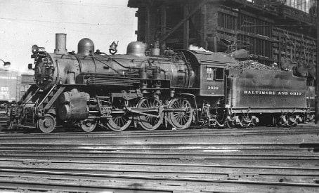
At left: B&O 4-6-0 (B18 class Ten-Wheeler) #2020 ran both the Ripley and Spencer Branches during the twilight years of steam. Image courtesy of Gary Mittner
|
Because of the characteristics of the line due to tight curvatures and light weight rail, only small type locomotives such as 4-4-0s and the 4-4-2 “Atlantics” could operate efficiently with the clearances of track. The turntable used to turn locomotives at Ripley restricted the size of motive power also. Freight volumes adequately suited for this power and typically created no operational drawbacks. If additional power was needed as in the case of heavier livestock trains, another locomotive was added on the rear as a helper. Track speed on the line was generally 20 MPH due to curves but my father witnessed trains exceeding this speed on the straight track at Evans heading west. He noted that the train would increase speed for the forthcoming grade at Angerona.
|
As the size of steam locomotives increased on main line railroads, older and smaller power such as 4-6-0 “Ten-Wheelers” were demoted from premium service in later years and migrated to secondary service such as branch line operation. Two classes of 4-6-0s were notable in use along the Ohio River line, the Ripley Branch, and the Ravenswood, Spencer, and Glenville (RS&G) Branch. These were the B&O class B-8 and the later superior B-18. But even the use of Ten-Wheelers along the Ohio River line and connecting branches was a unique anomaly. These locomotives remained in service longer on this route because of the outdated weight restricting bridge across the Kanawha River at Point Pleasant. It was not until 1947 that this bridge was replaced with a sturdier truss structure enabling the use of heavier 2-8-2 “Mikados” and 4-6-2 “Pacifics”. Despite the elimination of this bottleneck, the remaining 4-6-0s continued to operate exclusively on both the Ripley and Spencer Branches in yeoman service until history recorded that December 16, 1953 ended an era as the last steam locomotive led train departed Ripley. The hollows and meadows along the Mill Creek valley would echo with the puffing of steam and the shrill of a whistle no more. The following day witnessed the appearance of the first diesel locomotive in Ripley. Although efficient, it lacked the charm and character of steam as onlookers along the line must have gazed upon it with utter bewilderment.
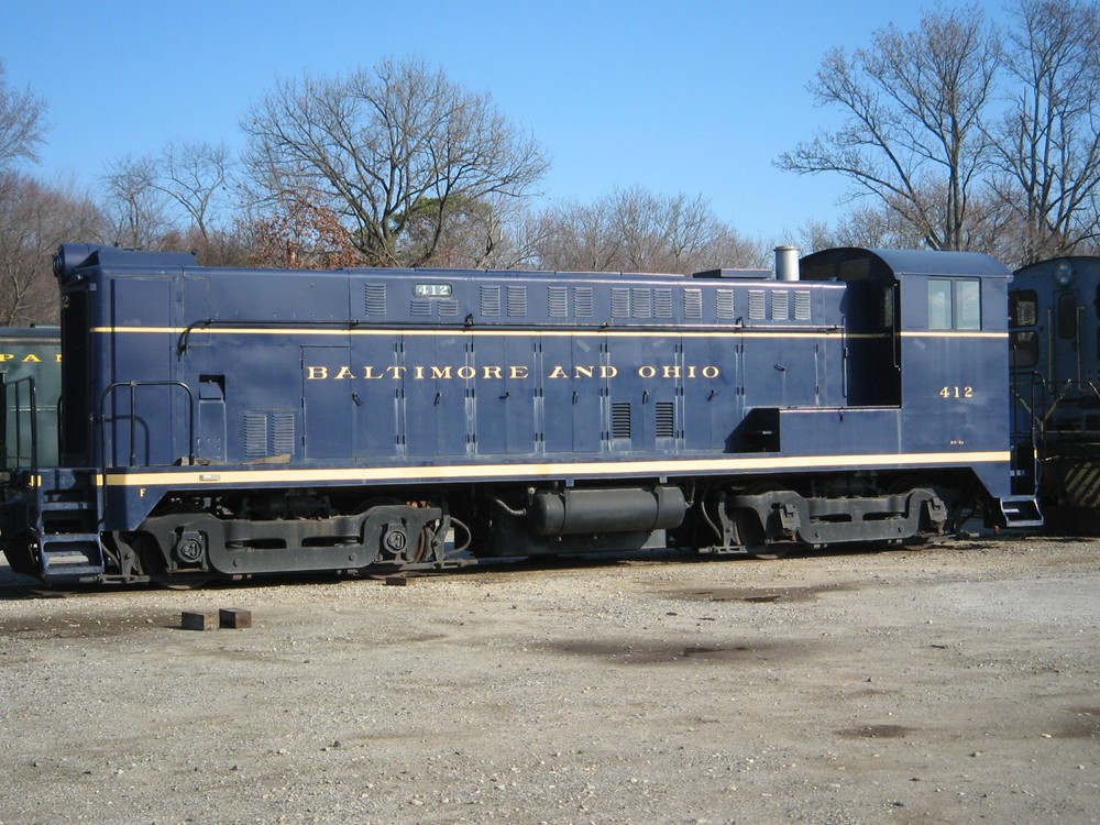
Baldwin VO 1000 repainted in B&O colors. Numbered #412, it is identical to the #428 that replaced steam on both the Ripley and Spencer Branches in late 1953. Photo courtesy of Kevin Painter.
This first diesel locomotive, a Baldwin VO 1000 numbered #428, operated on both the Ripley Branch and the R&SG. There is certainly the possibility that other small diesels were used on both routes as well but without documented accounts or photographs, this is only speculation. In fact, the operations on both lines were interrelated as had been the case for a number of years. Departing Spencer as Train #458 to Ravenswood, it would then run as an extra to Millwood. Changing symbols, Train #962 would then run to Ripley, returned to Millwood as Train #961, and then continued onward to Ravenswood as an extra where it diverged on to the RS&G to Spencer as Train #457. After dieselization, this operational practice remained but for a brief period. In 1954, further changes transpired.
Passenger service on mixed Trains #81 and #82, daily runs between Parkersburg and Kenova was abolished. In the past, Train #81 would briefly detour at Millwood as necessary for a run to Ripley, return to Millwood, then continue to Kenova. Although this run to Ripley ceased a few years earlier, it was symbolic of the rapid decline in train travel that was not only regional but nationwide. 1954 witnessed the end of daily mixed passenger and freight service to Ripley with the service reduced to three days a week. Not only was this change in reaction to the decline in passenger travel but also economic conditions on the B&O that would climax by the end of the decade.
By the end of the decade, Ripley trains had disappeared as scheduled timetable runs. The route was handled by extra movements on an as needed basis. Finally, the economic realities of maintaining the Ripley Branch were realized in 1963. There were no more passengers and dwindled shipping did not justify the cost of keeping the line active and the branch was formally abandoned that year. The years of the livestock trains, the Jackson County Fair by train, and the ride to Ripley became but a memory.
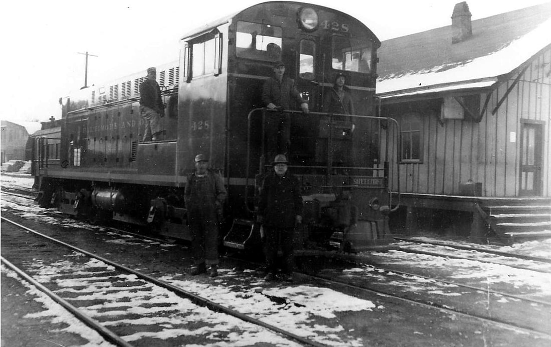
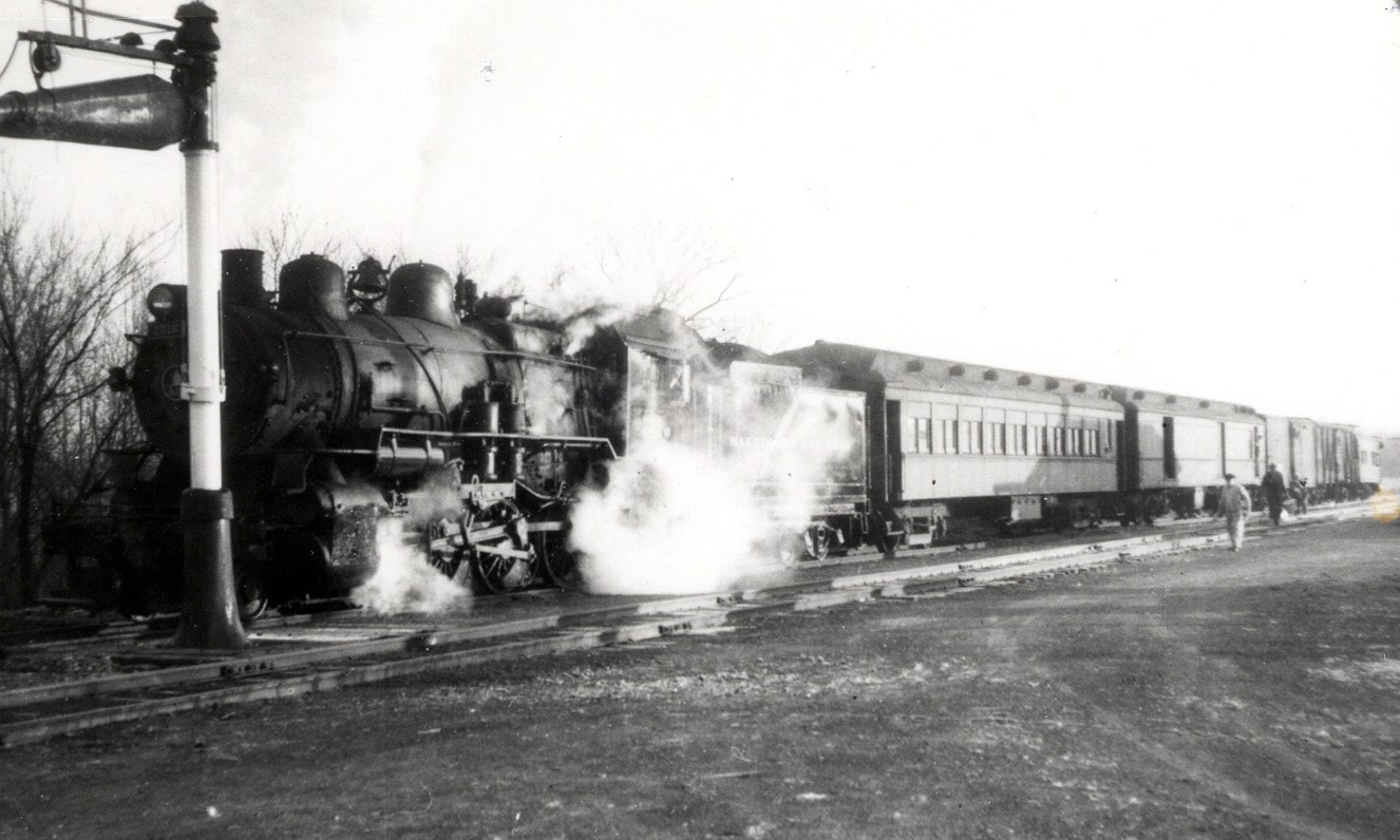
Shortly after steam had been displaced on the Ripley and Spencer Branches. This photo, circa 1954, captures for posterity Baldwin VO-1000 #428 and crew at the Spencer depot. Note that this is the same crew as pictured in the title photo at top. John G. King/Dan Robie collection
Train consists on the Ripley Branch were small. Often they ran mixed pulling a coach along with freight. As freight traffic declined, it was not uncommon for the train to be a locomotive and single coach only on a given day. In the halcyon years, there was livestock cars and trains, boxcars for general merchandise, hoppers for heating coal or gravel. Typical consists that varied due to seasonal volumes. Passenger ridership peaked in the early 1900s and then began a long gradual decline that accelerated in the post-World War II years.
Throughout the years listening to my dad talk about the trains on the Ripley Branch and mom of those at Millwood, it created a yearning to turn back the hands of time to see the line in operation. Today, when walking along the old right of way and especially at Evans, the feeling is of sadness. A small piece of Americana that has passed on---just as my mother and father ---that is dearly missed.
Throughout the years listening to my dad talk about the trains on the Ripley Branch and mom of those at Millwood, it created a yearning to turn back the hands of time to see the line in operation. Today, when walking along the old right of way and especially at Evans, the feeling is of sadness. A small piece of Americana that has passed on---just as my mother and father ---that is dearly missed.
1952 Timetable
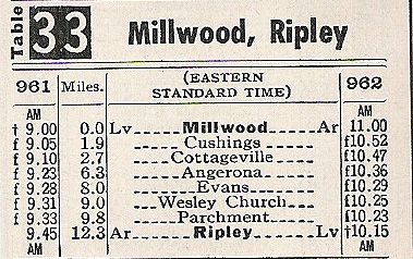
Published timetable from 1952 with Train #961 (Millwood to Ripley) and its returning counterpart, Train #962. Two locations on this timetable, Cushings and Wesley Church, cannot be found on any modern map but will be used as reference points in this works.
My thanks to David Sommer for the use of this image.
My thanks to David Sommer for the use of this image.
Millwood
Small towns along the Ohio River are a gateway to the past if for no other reason than they have maintained a charm that harkens back to an earlier time. The heydays of many have long ago passed but the character has remained intact. Millwood is no exception and although its primary association was to the river itself, for over a half century it was also the junction of the Ripley & Mill Creek Valley Railroad with the Ohio River Railroad of which both would eventually be absorbed into the Baltimore and Ohio Railroad network.
Southbound Train #81 stopped on the Ohio River Line at Millwood on December 1, 1949. This is a mixed train with a coach, baggage, freight cars and a caboose. Note the metal water post in lieu of the standard wooden tower at this late stage of the steam era. John G.King/Dan Robie collection
|
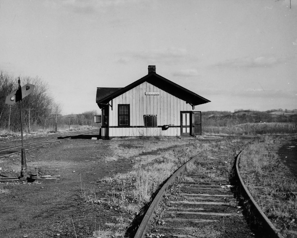
Millwood depot in solitude during late 1950s after passenger trains ran no more. The track is the west leg of the wye to the Ripley Branch. Image John P. Killoran/Bob Withers collection
|
Train Time 1915
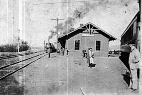
In the scene at left from the golden era of passenger rail, a southbound train comes to a stop at Millwood. The train at right is on the west leg of the Ripley Branch. Image courtesy of Keith Pride
The junction at Millwood was a wye. That is, there were two connecting tracks that joined the Ohio River line with one connection headed north and the other headed south. Although the majority of traffic from the Ripley Branch moved north, there were instances of trains coming off the Ohio River line from the north running to Ripley then returning to the River line and continuing south. An added benefit of this wye connection and especially in the days of steam is that it enabled a locomotive to be turned around and face the direction from which it came. Inside this wye was the Millwood railroad station which faced the Ohio River line being it was the primary route. Unfortunately, not unlike uncounted railroad depots across America, the structure was demolished during the 1960s.
The junction at Millwood was a wye. That is, there were two connecting tracks that joined the Ohio River line with one connection headed north and the other headed south. Although the majority of traffic from the Ripley Branch moved north, there were instances of trains coming off the Ohio River line from the north running to Ripley then returning to the River line and continuing south. An added benefit of this wye connection and especially in the days of steam is that it enabled a locomotive to be turned around and face the direction from which it came. Inside this wye was the Millwood railroad station which faced the Ohio River line being it was the primary route. Unfortunately, not unlike uncounted railroad depots across America, the structure was demolished during the 1960s.
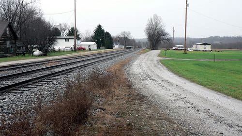
Ripley Line roadbed near where it joined the Ohio River line, now CSX. This was the north, or railroad east, leg of the wye. View is north looking towards Ravenswood. Dan Robie 2011
|
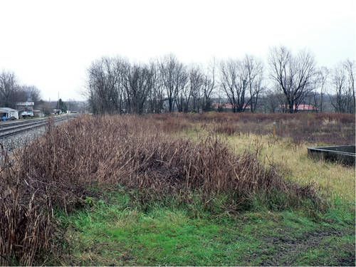
Location near where the Millwood depot once stood. Once the focal point of the community, all that remains are weeds and memories. Dan Robie 2011
|
By rail, Millwood was the outside world connection to and from the Ripley Branch. Freight and passengers traveled from here to Huntington to the south or to Parkersburg and Wheeling to the north or perhaps a number of towns in between. Train travel in those earlier times was not always a long distance affair. Due to fewer automobiles and poor roads, a trip by rail from Ripley to locations such as Letart or Ravenswood was not uncommon.

|
|
|
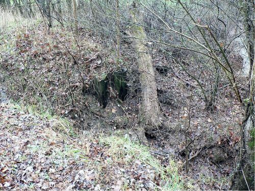
Foundation stones from a long ago water tower used during the steam era. Water towers were a vital component of the steam era railroad with virtually every location of consequence equipped with one. Dan Robie 2011
|
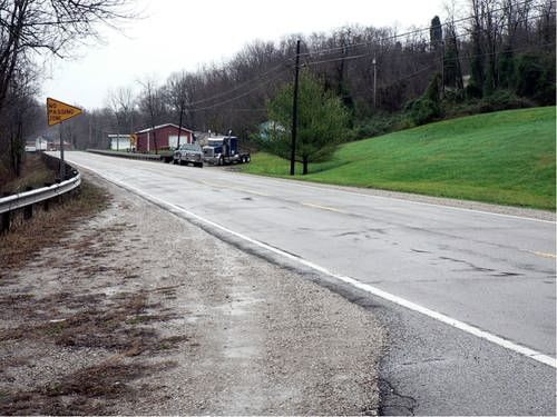
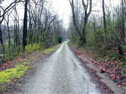
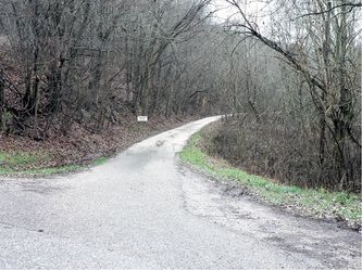
Ripley line right of way swinging away from river line headed for WV State Route 2. Now used as a road. Dan Robie 2011
|
|
|
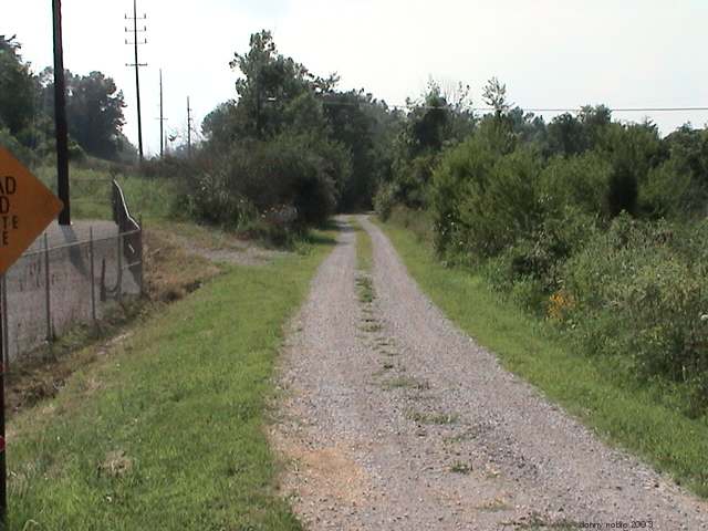
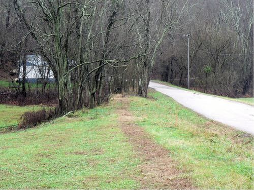
Left: Railroad right of way between Ohio River line and WV State Route 2. View is to the east. Right: Where the railroad crossed WV State Route 2. Right of way is in direct line with the trucks across the road. This crossing was crossbuck protected and among my earliest railroad memories were the ties and rail stacked here from the track removal. Both images Dan Robie 2003 and 2011
Millwood was never a major place location for the railroad but it was notable by virtue of being a junction point along with a few small shippers. My mother lived her youth at Millwood and her mother, Harriet Hannum, worked for many years at the post office there well into the 1950s. When Mom was not riding a train to Ripley or Wheeling, she was witness to the B&O there on an almost daily basis. One of her accounts--one that I initially omitted--was of the railroad during the Great Depression. The 1930s were the great era of the traveling hobos who rode the trains. They would occasionally stop at the house in Millwood to ask for food before camping along the railroad or river bottom to await the next train. Sometimes it would be a family drifting from one location to another seeking work or simply foraging to stay alive. The life of the hobo has been glorified to an extent these many years later but they were a product of the hard times in that era.
But that was part of everyday life then for her just as contemporary life for us today. Only in hindsight can we truly appreciate the simplicity of what once was as compared to changes henceforth. Life was tough then just as today. Only then, it seemed a bit less complicated.
But that was part of everyday life then for her just as contemporary life for us today. Only in hindsight can we truly appreciate the simplicity of what once was as compared to changes henceforth. Life was tough then just as today. Only then, it seemed a bit less complicated.
An eastbound view of the B&O at Millwood in 1981. The dilapidated siding has long since been removed and this location is near the former junction of the Ripley Branch. The Chessie System was in full bloom during this era. Dan Robie 1981
|

Present day rail scene at Millwood as CSX train Q316 runs eastbound towards Parkersburg. Two scheduled trains pass through Millwood daily in addition to locals and extra movements. Dan Robie 2011
|
The Millwood of my mother’s youth as the group of photos above suggest is but a memory now. It has been nearly a half century since the last run on the Ripley line or that a passenger train stopped at Millwood. The Ohio River line still lives on, however, in the form of CSX with two scheduled daily freights, local runs, and coal traffic.
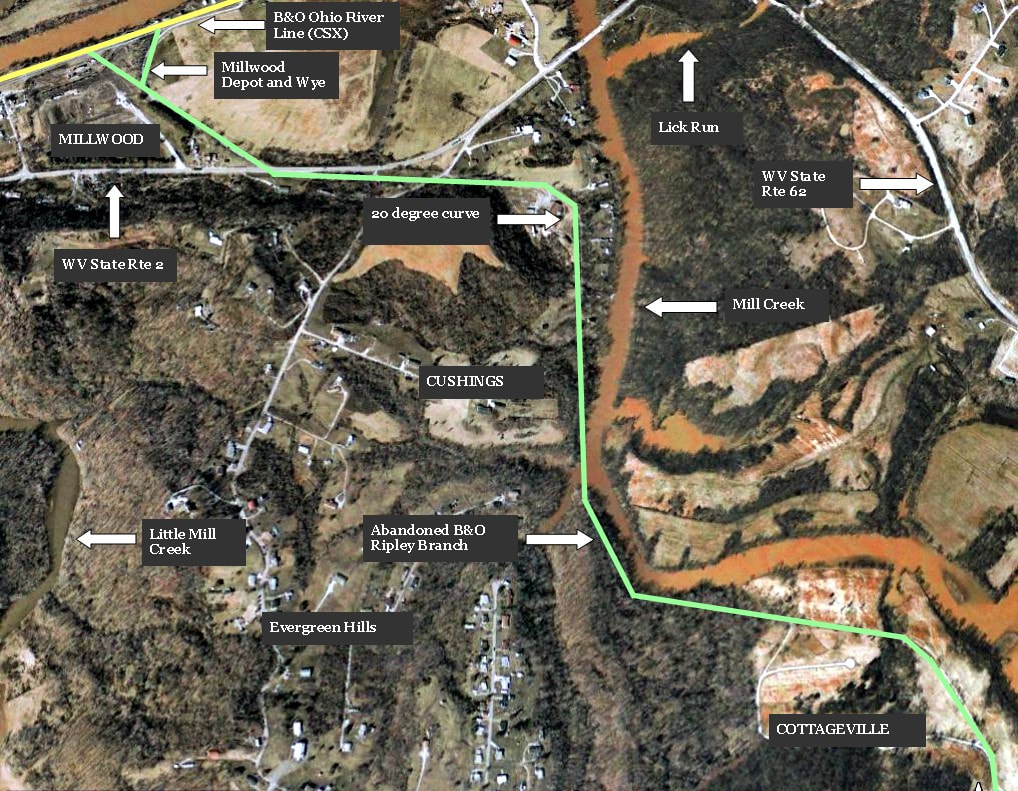
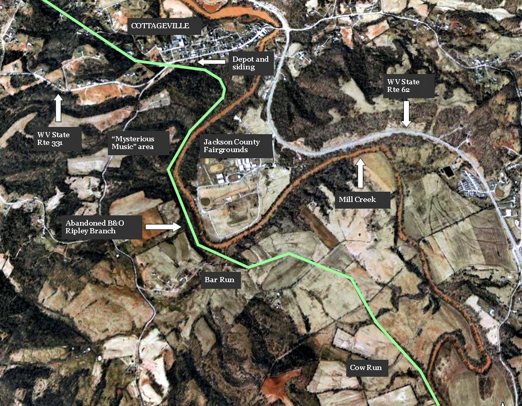
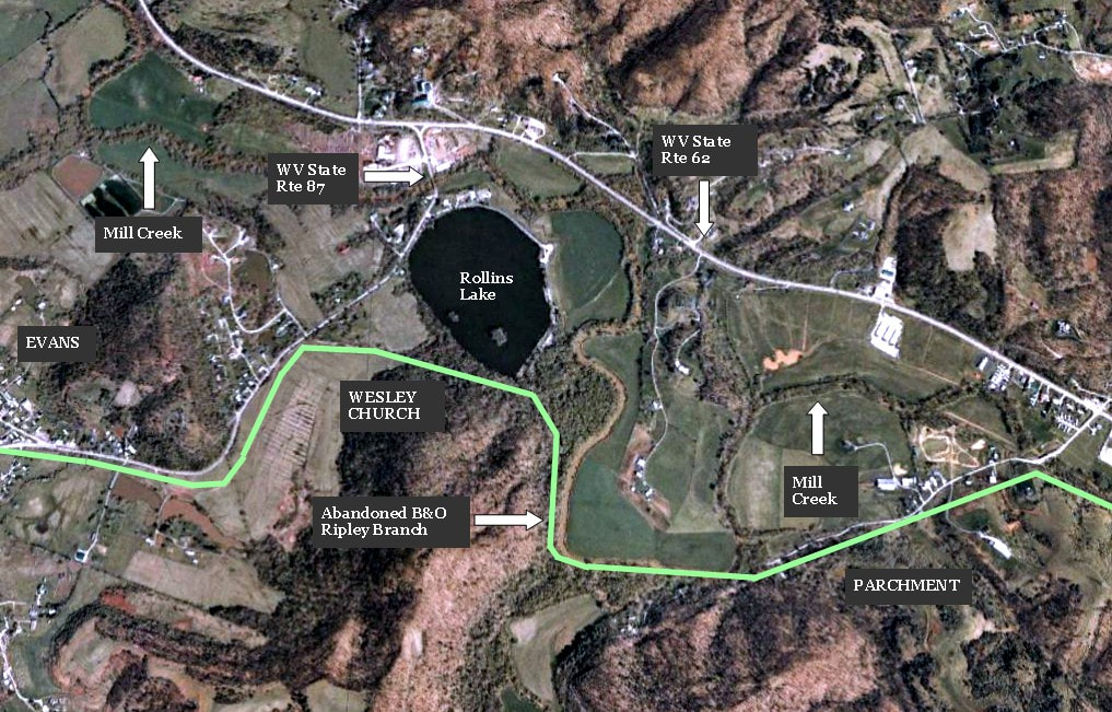
A Google Earth capsule of the region extending from Millwood to Cottageville. The Ripley Branch junction with the Ohio River line with a wye connection turns to the Mill Creek basin. It then passes through the lost place name location of Cushings and bottomland before entering the community of Cottageville.
Cushings
Cushings is a name that appears on the B&O timetable but the significance of this location appears to have faded into history. I never heard any family references to it nor could I find this place name in any research. This may have been a landowner or perhaps, a railroad employee from the distant past but there is no certainty and it is only opinion in this case. What is fact is that it is an area roughly midway between Millwood and Cottageville where the railroad paralleled Mill Creek before turning across fields to enter Cottageville.
|
|
|
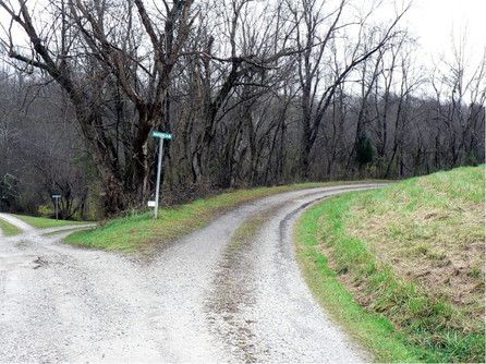
This scene may still be geographically Millwood but is in proximity to Cushings. Today this is Raccoon Lane but it was the railroad right of way where the line encountered its tightest curve on the 12.3 mile route. Dan Robie 2011
|
The right of way past the curve at Cushings heading east towards Cottageville. I hope to get additional photos of this area closer to Cottageville at a future date. Dan Robie 2011
|
Place name mystery notwithstanding, Cushings was notable as it was here that the tightest curve (20 degrees) on the line was located. It was the site of derailments throughout the years typically involving the locomotive pilot wheels ahead of the drivers. On a line with a 20MPH speed limit, the engineer would need to reduce the throttle further to successfully (and safely) navigate this curve.
Cottageville
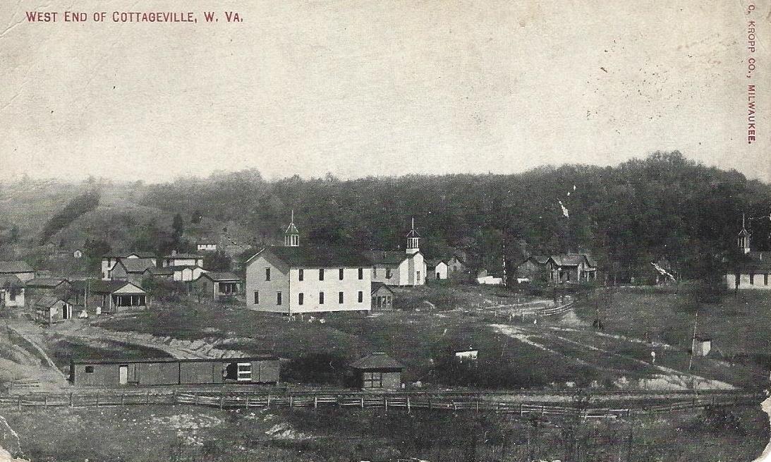
This early 1900s photo clearly shows the railroad and its relationship to the town of Cottageville. Visible in the foreground is also a rail siding with two boxcars converted for storage and a small depot. The Cottageville in the image above is the one that John House saw when he was writing the history of the area that predated his time. A photograph would be impossible from this perspective today due to years of unabated tree growth. Image Jackson County Historical Society
"The Village of Cottageville is situated on the upper level at the falls of Mill Creek, where the stream breaks from the plateau known as the Mill Creek flats, into the lower level of the backwater lands. The first post office in Jackson County, was established at Wright’s Mills.”-John House
The Cottageville of the 21st century has similarities to the one of yesteryear but it has not been untouched by the hands of time. The Falls of Mill Creek are long gone having been submerged by the backwater from the Ohio River created by the lock and dam at Racine. The grist mills are tucked away in the closet of history as is in more relatively recent times, the high school and the B&O Railroad. Another not so distant memory is of the high school that stood just the grade crossing of old US Route 33. Both of my parents as did their siblings attended high school there.
The railroad entered the west end of town from what is now Laura Lane then crossed present day Route 331. Cottageville High School once stood to the right of this scene. Dan Robie 2003
|
This view is 180 degrees about from the photo above. The railroad crossed Route 331 at this location and ran in direct line with the large cedar tree ahead. I can remember as a youngster a crossbuck still standing here although the track was gone. Dan Robie 2011
|
By 1950, B&O continued to list a siding still intact at Cottageville although the last rail shipper had long since vanished. The siding was primarily a team track used by merchants in the area for the delivery of goods and during its early years, a water station was located here.. Interestingly, the track passed through the community on the opposite side of Main Street from the commercial district. As it moved eastward from town, the railroad traversed a grade on a sharp curve and again began its parallel of Mill Creek. Today, the right of way through Cottageville is heavily choked with growth and areas it could be accessed are directly behind private property. However, the winter months minus any snow cover would offer the only reasonable expectation of exploration.
Cottageville....1910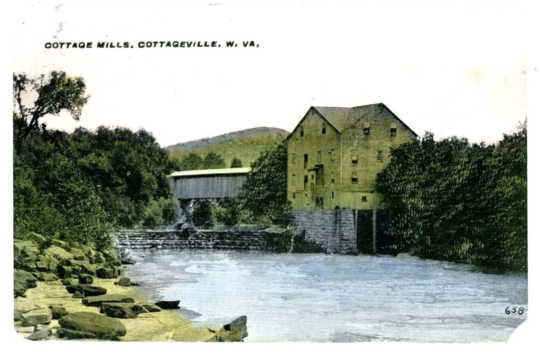
Postcard of the Cottage Mills and dam at Cottageville from the early 1900s looking east. This scene corresponds with the photo at right except for the opposite vantage points. Image Jackson County Historical Society
|
Cottageville...2005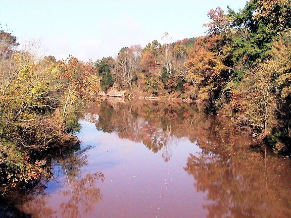
Mill Creek looking west at Cottageville. Ruins of a grist mill stood at right along the creek bank not visible in this scene. It is here that Mill Creek becomes wider and deeper as a result of Ohio River backwater pooled by the lock and dam at Racine. Dan Robie 2005
|
As a post script, there is a folklore account that pertains to this area, Long time area residents may be aware of a ghost story concerning a railroad engineer that lived along the tracks in the vicinity many years ago who loved music. When the track was pulled up, his old house was also destroyed and afterward his ghost was sighted along with the sound of music near Christmas time.
The book this account appears in is "Coffin Hollow" and the story is titled "The Mysterious Music" by Ruth Ann Musick first published during the 1970s. Reprinted editions can be still be found if you want hard copy. If you are not interested in locating the book for the entire content, click the below link and scroll down to Tale #12 or click the Google page selection to 29. The complete volume can also be downloaded as an E Book.
Google Books Coffin Hollow and Other Ghost Stories

Early 1900s view of the railroad near Cottageville heading east towards Cow Run. Perhaps the location of the mysterious music? John G. King/Dan Robie collection
|
On the opposite bank of the placid Mill Creek east of Cottageville is the roadbed of the long gone B&O Ripley Branch. Masked by dense growth, the right of way is only visible once autumn cedes its vibrant foliage to the barren days of winter. Dan Robie 2015
|
Cow Run Area
"Cow Run is the first considerable stream falling into Mill Creek on the south side. It is a country basin shaped with low hills gradually ascending from the bottom lands, running back perhaps a half mile or more, to the tops of the ridges. The hill sides are not steep or bluffy, and are all cleared out and green with succulent pasturage, timothy, blue grass and red top, and along the roadway at the base of the hill nestles cozy white farmhouses surrounded by orchard and garden, truly a beautiful picture as seen from a train window on a hot day in early August, 1904."----John House
If John House could ride a train through the appropriately named Cow Run a century later he would no doubt still recognize the meadows and farmland of these serene fields. The railroad briefly parted from the contour of Mill Creek by running through this idyllic setting. Two trestles were located in this meadow land with crossings of Bar Run and Cow Run respectively. This area was one of two locations--Evans, the other--that presented no challenges to trains in either direction on relatively flat ground.
If John House could ride a train through the appropriately named Cow Run a century later he would no doubt still recognize the meadows and farmland of these serene fields. The railroad briefly parted from the contour of Mill Creek by running through this idyllic setting. Two trestles were located in this meadow land with crossings of Bar Run and Cow Run respectively. This area was one of two locations--Evans, the other--that presented no challenges to trains in either direction on relatively flat ground.
This 2007 Google Earth freeze frame focuses on the region between Cottageville and Angerona generally referred as Cow Run. The green line traces the railroad right of way through the serene pastoral meadows and farmland of the area adjacent to Mill Creek.
Westbound view along Mill Creek at the Bar Run crossing. A few trestle bents remain as a reminder of the railroad passage. Image courtesy Charles Fox
|

Abandoned right of way through the pastoral setting of Cow Run. View looks west from the transition of a private road to roadbed. Image courtesy Charles Fox.
|
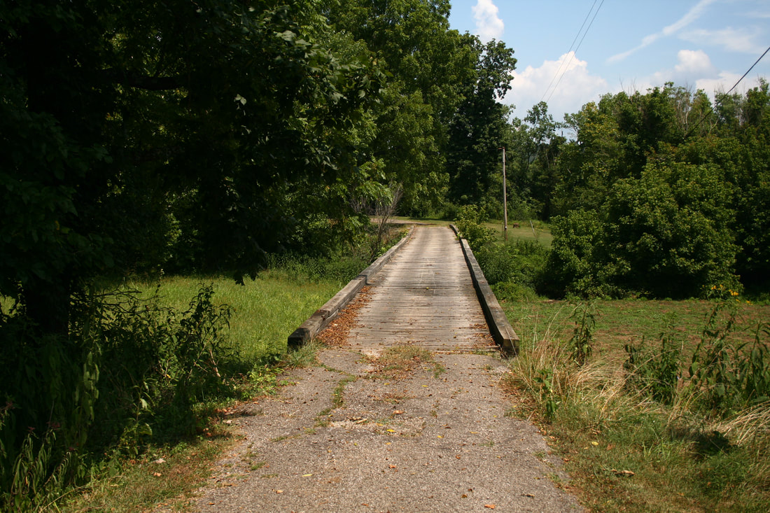
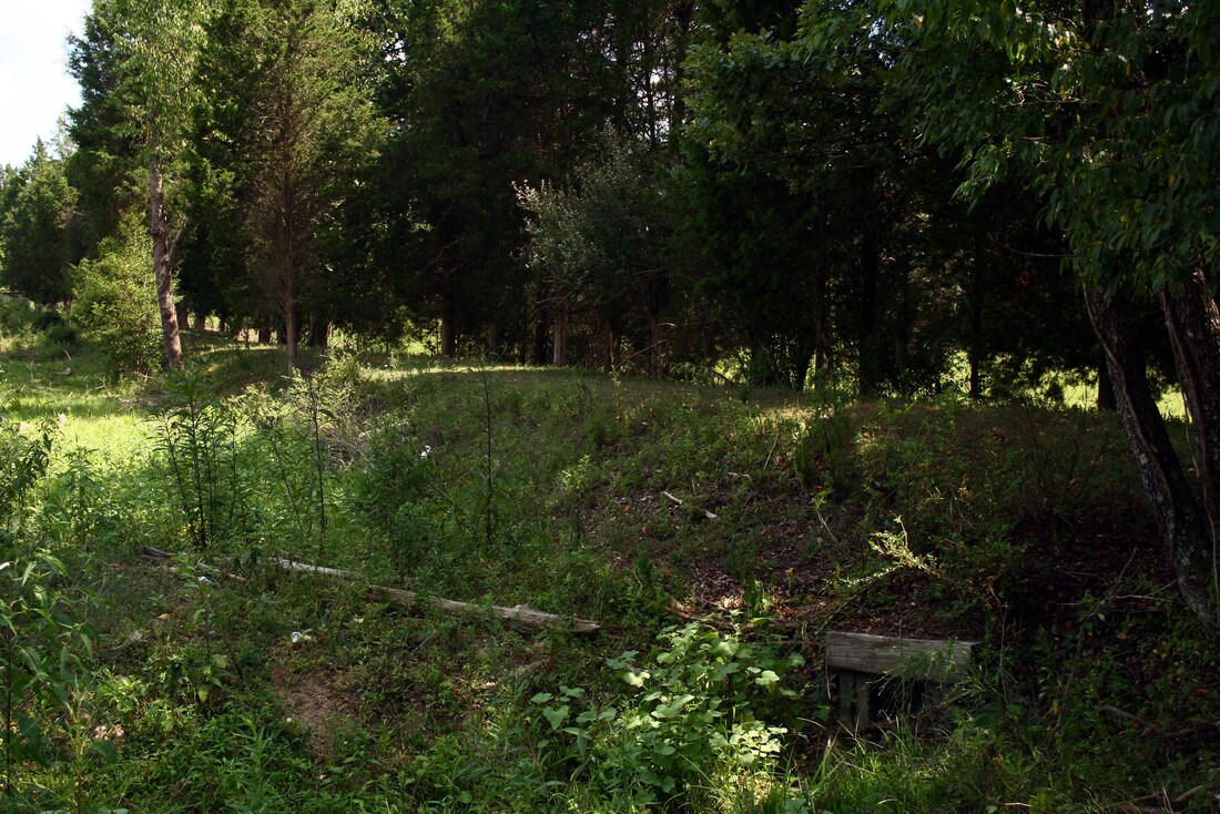
Westbound view across the Cow Run trestle. As this is now private property, the owner repaired and planked the floor for vehicular traffic. Dan Robie 2019
|
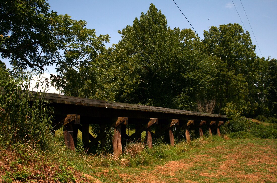
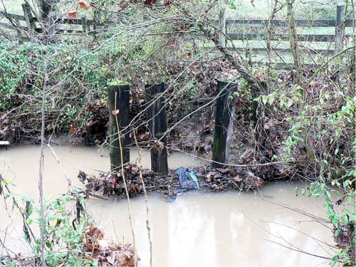
The trestle at Cow Run is the only remaining intact span from the Ripley line. As trestles on the line went it was among the longer ones. Dan Robie 2019
|
Angerona
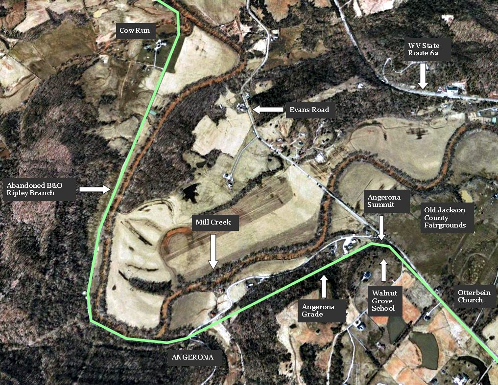
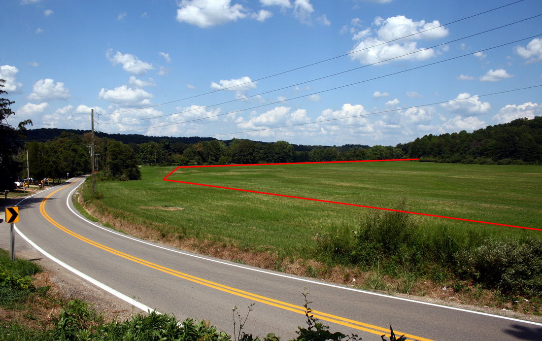
The railroad moved east from the Cow Run bottom land and curved into the hilly area at Angerona. It was here on the ridge above Mill Creek that the line faced its toughest gradient on the 12.3 mile route. By contrast, ahead lay the longest tangent on level ground through the community of Evans.
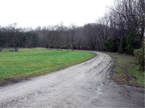
Railroad right of way looking west from Angerona towards Cow Run. Marked as a private road, this was the path of the railroad between Angerona and Cottageville . Dan Robie 2011
|
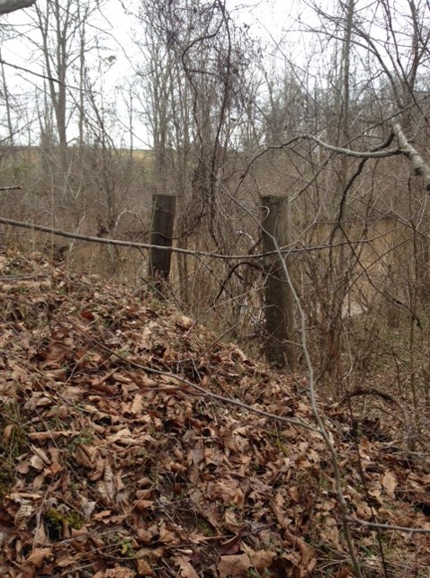
Trestle remnants at a small unnamed creek crossing at Angerona. These wood trestle pilings can still be found at other locations as well. Dan Robie 2011
|
In Roman mythology, Angerona is the goddess of secrecy and silence. Certainly the secrecy aspect would apply to the little hamlet of Angerona tucked away in the Mill Creek valley between Evans and Cottageville. But when it came to train time at this location near the midway point of the line, quietude would hardly be applicable.
From an operational standpoint, Angerona was the toughest obstacle on the line because trains faced a short but steep grade from either direction. Worse yet, the climb on the east side from Evans was on a curve. The 4-6-0 “Ten-Wheeler” steam locomotives would hit this grade and the driving wheels would slip on the climb. The sound of the locomotives toiling up this gradient could be heard for miles.
From an operational standpoint, Angerona was the toughest obstacle on the line because trains faced a short but steep grade from either direction. Worse yet, the climb on the east side from Evans was on a curve. The 4-6-0 “Ten-Wheeler” steam locomotives would hit this grade and the driving wheels would slip on the climb. The sound of the locomotives toiling up this gradient could be heard for miles.
Right of way looking west at Angerona. This scene is repeated at various locations where the right of way bordered farm land and wooded areas. Dan Robie 2011
|

Angerona Grade on its west slope. The right of way parallels Angerona Road once again here. An abundance of large timber adds credence as to how long this right of way has been abandoned. Dan Robie 2011
|
Trains heading for Millwood at least had the advantage of the long straight stretch through Evans to make a run for the hill at the east slope. Ripley bound trains would hit the west slope of the grade just to the east of Cow Run. Although trains had a run at the west slope, it was not as long a tangent that existed at Evans. In rare instances, two locomotives with one as a helper on the rear would be needed if the livestock trains departing Ripley warranted it due to the challenge at Angerona Grade. When the diesel locomotive arrived on the scene in the twilight years of the railroad it fought the same battle but with far less drama.
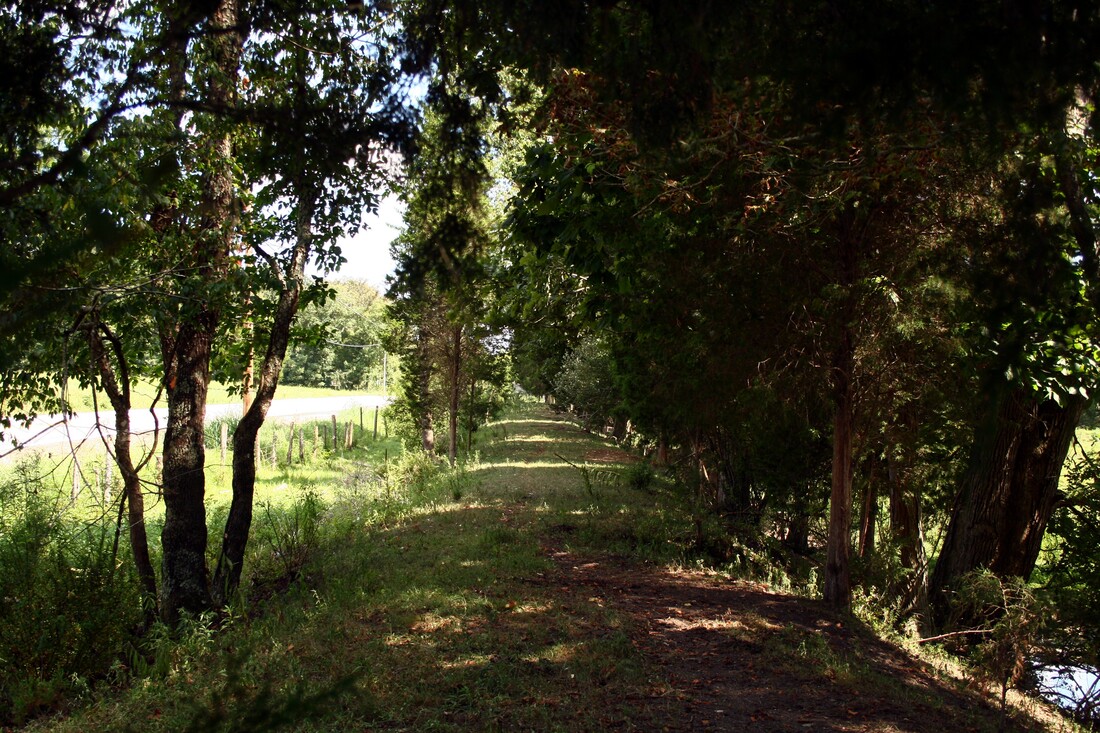
Right of way at Angerona Grade as seen from Angerona Road. One of few remaining locations along the 12.3 mile route that the roadbed is still clearly defined. Dan Robie 2011
|
The right of way looking west from the summit of Angerona Grade. Telltale signs are apparent that a track once ran through here. This location is near the crest of grade. Dan Robie 2011
|
The engineers who surveyed the original route for the Ripley and Mill Creek Valley Railroad could have avoided Angerona Grade altogether but would have placed the line at the mercy of Mill Creek during high water. It is interesting to note that along the twelve mile route, the railroad paralleled Mill Creek but was built as far away or high enough from it to avoid rising water. Hence, this is the reason why the track was constructed on the ridge at Angerona with two trestles to span ravines and bottoms. Better to battle the hill rather than rebuild washed out track.
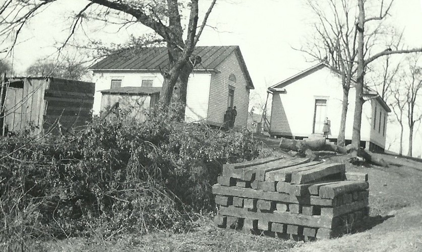
Walnut Grove school buildings on the slope between Otterbein and the Angerona grade. Undated image but possibly the 1960s during the track removal. Note the stack of used railroad ties. Image courtesy Jackson County Historical Society.
|
Abandoned railroad roadbed on the climb to Angerona. Decrepit school building is the same one at right in previous image. Dan Robie 2011
|
My father had a front row seat of the action at Angerona. Having lived at Evans near Otterbein Church, he was witness to many a train battling the east slope of the grade. He cited this location as the most vivid of his memories of the Ripley Branch. Indeed, so imposing was the grade during its early history that an unidentified frustrated passenger described an account published by the Point Pleasant Register during the late 1880s shortly after the line began service. She described a trip from Millwood to Ripley that took more than two hours to complete because the underpowered mixed train of passengers and freight stalled on the grade three times.
Evans
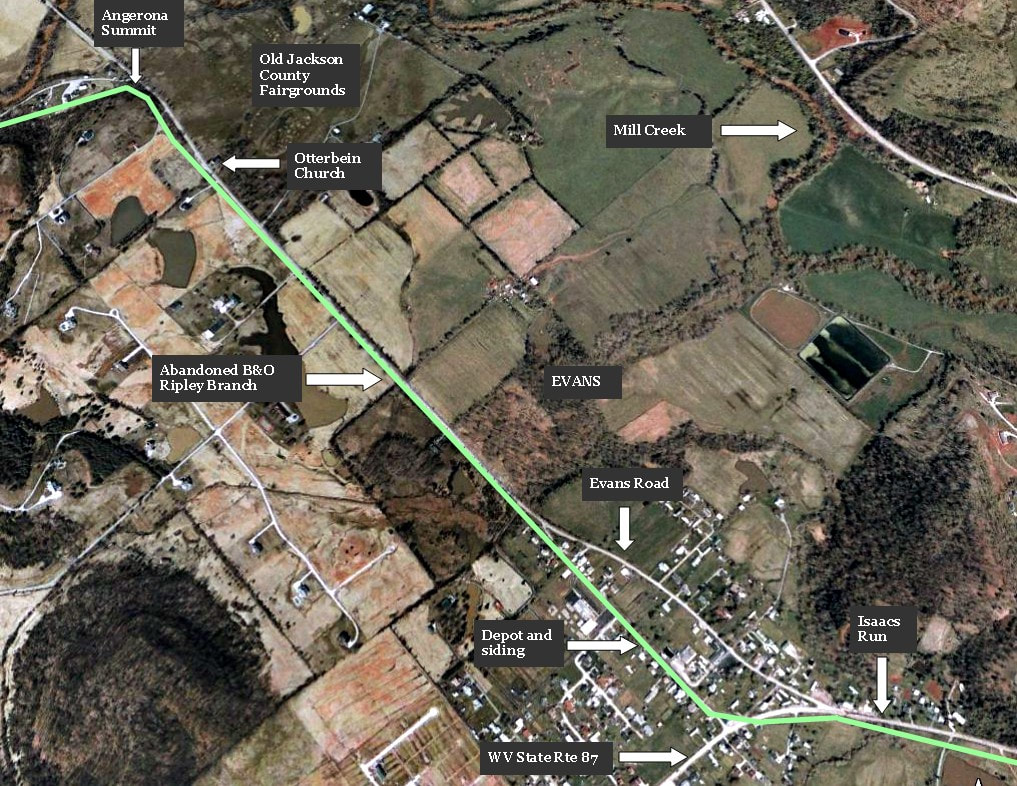
Google Earth view of the area extending from Angerona to the east end of Evans. The railroad, highlighted in green, ran on a tangent through Evans passing Otterbein and the old Jackson County Fairgrounds en route. Visible at top left is the outline of the fairground track as the railroad temporarily left the bank of Mill Creek.
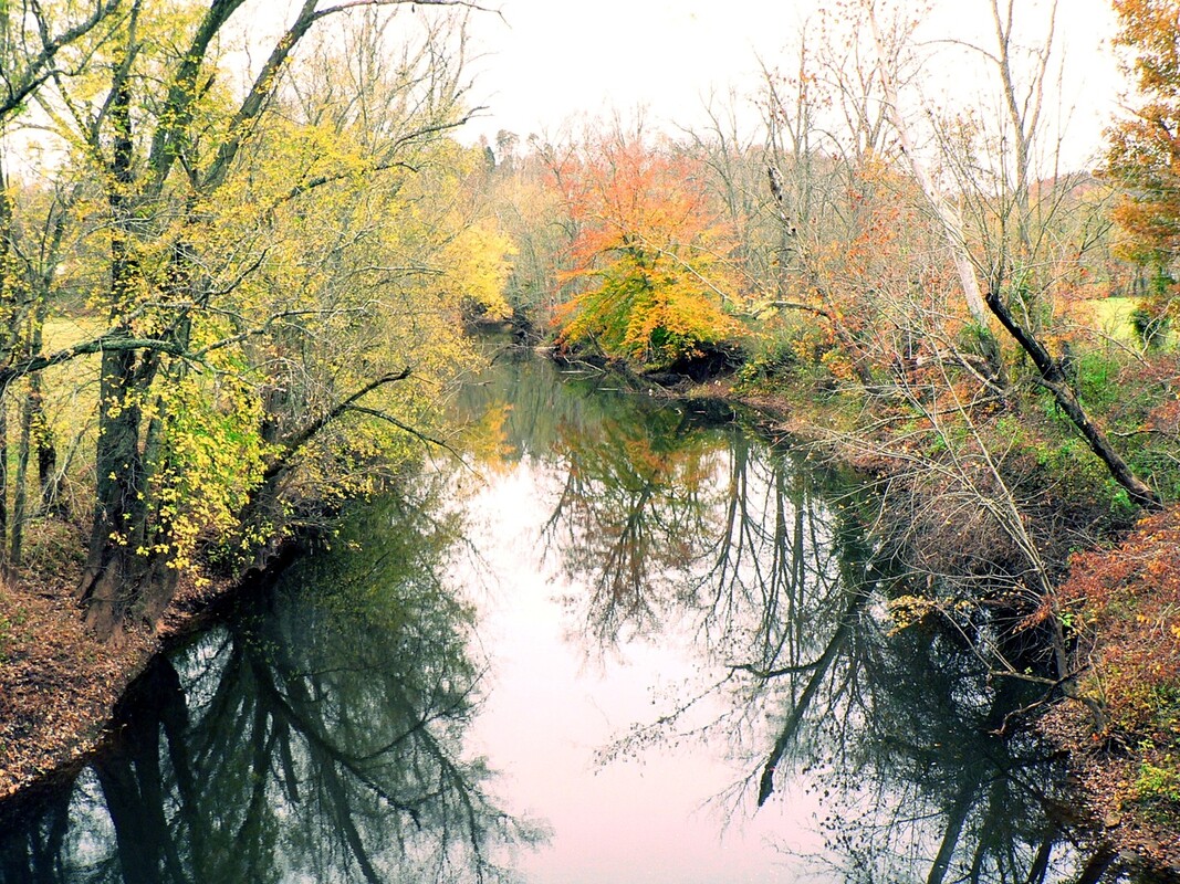
Autumn splendor along Mill Creek west of Otterbein opposite Angerona Grade. This may be the only time your author can recall ever seeing the stream without the red clay color so synonymous with the farmland it traverses. Dan Robie 2015
Otterbein...1930s |
Otterbein...2011 |
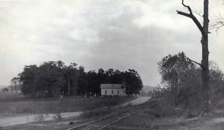
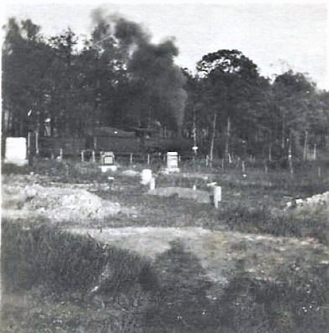
A very rare view of the railroad looking east at Otterbein Church circa 1930s. This scene would have been quite familiar to my father as a young man living at Evans during this time period. The older section of the cemetery is visible by the church and the Jackson County Fairground is out of view just to the left of the frame. Image courtesy Jackson County Historical Society.
|
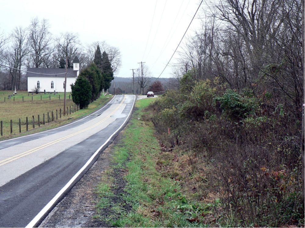
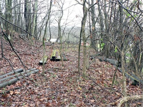
In the photo above facing east, the railroad right of way covered with growth runs alongside Evans Road and includes the parking area for Otterbein Cemetery where the car is located. This was once the whistle stop for the Fairgrounds at Otterbein. The westward climb to Angerona begins here. Dan Robie 2011
|
|
Evans held the distinction of being located on the straightest stretch of track on the 12.3 mile route. Moving eastward from Otterbein Cemetery near the base of the Angerona climb to the heart of the community at Route 87, the track was an arrow straight tangent that paralleled Evans Road with a trestle crossing included. The railroad was on a small plateau here above the Mill Creek flood plain as it passed through the widest expanse of valley along the creek. Once at Route 87, the track turned north, crossed Isaac Run and ran alongside Route 87 before turning east just before the present day Rollins Lake.
Rare early 1900s image of a train moving past Otterbein Cemetery. Although the image is not sharp it is an invaluable photo nonetheless. Image Jackson County Historical Society
|
Like Cottageville, Evans was a flag whistle stop for passengers and occasional freight related to farming and livestock. A siding remained here still of record to B&O by mid-century used for agricultural purposes. B&O timetables into the 1940s also listed a flag stop when the Jackson County Fairgrounds was located here--the train would stop at Otterbein Church for passengers attending the fair. The simple life in a most picturesque setting.
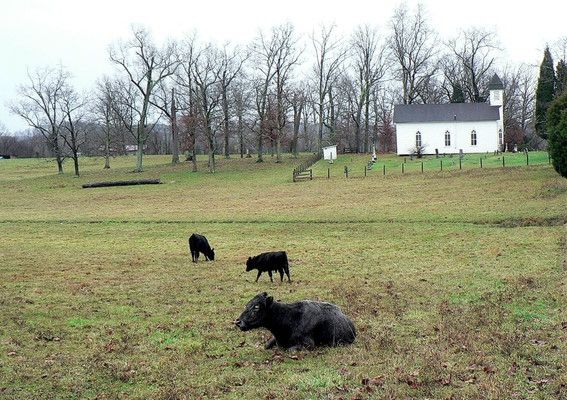
A scene that is the tranquility of Evans. The landmark Otterbein Church stands as a sentinel in the background surrounded by pasture fields and cattle. Many years ago, this large pasture was the site of the Jackson County Fairgrounds. Growing up at Evans, my father had fond memories of this time and spoke of the number of people that would ride the train to and from the fair. Dan Robie 2011
|
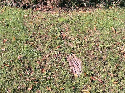
A railroad tie embedded in the ground just past Otterbein. Old, unsalvageable ties were often left in place. Another location that ties remained for years was to the east at Parchment. Dan Robie 2003
|

From Otterbein looking east. The right of way runs down the right side of Evans Road although the evidence of it here is sparse. Dan Robie 2011
|
Along Evans Road midway between the town and Otterbein. Farmland and developed real estate has rendered much of the right of way undetectable today. Railroad was to the right. Dan Robie 2011
|
Evans...1951 |
Evans...2019 |
Train #962 runs westbound at Evans with a single coach in this 1951 scene. This image is the rarest of the rare. Ripley Branch photos are extremely scarce and this is one of few ever published of a train on the line at a location other than Ripley. Richard J. Cook photo.
|
This location is in proximity to the Richard J. Cook photo at left. The railroad right of way has reverted to farmland and cattle now graze here. Dan Robie 2019
|
The lazy sway of the trees mask a well-defined right of way where the last B&O train passed more than a half century ago. Adjacent to Evans Road between Otterbein and the town center of Evans. Dan Robie 2019
The Evans of my father's youth was that of fertile farm land and pastures for raising livestock. While this is still in evidence but to a lesser degree today, the area has also witnessed the development of prime real estate in the intervening years. I can recall my dad talking about the old Walnut Grove School that stood just opposite of Otterbein Church but the passing years have erased the details from my memory. As it is, this community was and still is a nostalgic location in the annals of family history. Today it is hallowed ground as both my parents and paternal grandparents are interred at Otterbein Cemetery.
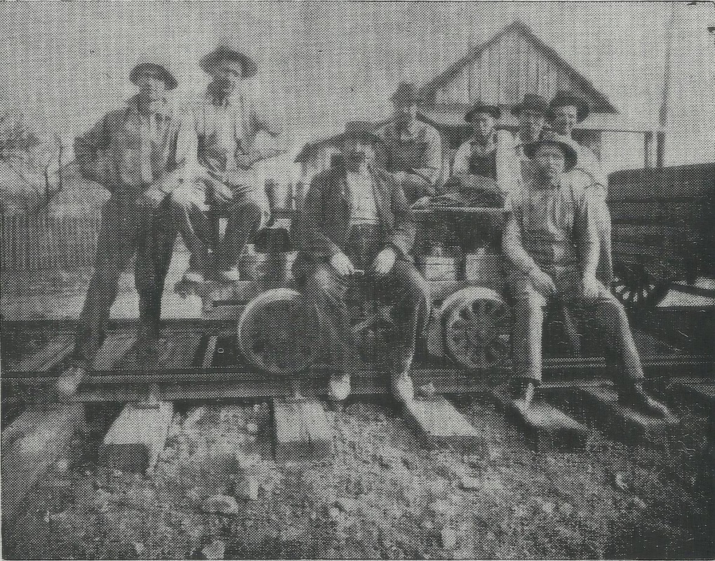
A track gang poses for a photographer at Evans in 1915 and still looks at us a century later. They are posed at the switch for the Evans siding. Image courtesy Jackson County Historical Society
|
West view through the heart of Evans during the Depression 1930s. Evans siding is barely visible at right. Nothing remains in this photo today. Image Jackson County Historical Society
|
Evans was a bustling community when this circa 1910 photograph was taken. Farmers would both ship and receive their wares by rail as evidenced by the boxcar in the siding. My paternal grandfather was familiar with Evans as it is in this scene. Image West Virginia and Regional History
|
The center of the town of Evans as it appears today. Railroad paralleled the street on the left but few telltale reminders of its existence remain along this stretch. Dan Robie 2019
|
Right of way between WV Route 87 crossing and Isaac Run trestle. The line crossed the road to the left of the steeple side of the church. Dan Robie 2011
|
Right of way looking west back to town at the WV Route 87 crossing. The right of way through here has remained moderately clear except for the growth of cedar trees. Dan Robie 2011
|
At the intersection of Evans Road and WV Route 87, the roadbed becomes readily visible once again. Trestle bents remain in place at Isaacs Run as the roadbed parallels the sweeping curve of the highway. Moving towards Ripley, the outline of the roadbed is visible as it made its way toward the timetable name Wesley Church area.
Pier remnants in Isaacs Run beside present day WV Route 87. Most of the timber from the trestles was salvaged when the track was removed. Dan Robie 2011
|
The red line marks the railroad right of way in the pasture east of Evans along WV Route 87. Rollins Lake is beyond the tree line at the railroad timetable location of Wesley Church. Dan Robie 2019
|
Wesley Church
Similar to the previously noted railroad name of Cushings, Wesley Church is another place name on the timetable that appears to have faded into history. During research of the area, I was unable to locate any references to it whether it be geographic or archival. In addition, neither of my parents or long time residents of the area I have spoken to have any knowledge of the location significance. As the name suggests, it perhaps was a church which existed during the late 1800s-early 1900s that was perhaps demolished. In any event, unless a revelation is discovered it will remain lost to history.
This map depicts the region east of Evans at timetable location Wesley Church extending into Parchment. The railroad bypassed the sharp bends of Mill Creek by following the hilly contour south of present day Rollins Lake until resuming the parallel with Mill Creek at Parchment.
In terms of the railroad, it was the region that existed between Evans and Parchment. As the track turned east from Evans, it crossed meadow land and returned to the low hilly area that paralleled Mill Creek at Parchment. The center of this area is roughly the region bordering present day Rollins Lake.
Another 1951 photo of Train #962 and a single coach loafing through the countryside. This area is between Evans and Parchment near the timetable location of Wesley Church. The large tree beside the railroad here adds to the rural flavor. Photo Richard J. Cook/courtesy Allen County Museum All rights reserved
Parchment
Whence more than a half century ago that trains once passed, trees and brush now claim the right of way. At the west end of Parchment, the railroad ran between Parchment Valley Road and Mill Creek. Dan Robie 2016
|
A view that captures the rolling hills and country side at Parchment. The vantage point of the photo at left is standing on the railroad right of way facing east. A trestle spanned the cut as the track paralleled the road to the right. This area is high above the bank of Mill Creek which is out of view to the left. Moving east, the railroad continued to follow the creek until reaching its terminus at Ripley. Dan Robie 2011
|
According to the writings of John House, "two miles above Evans, still on the south side, a large creek flows into Mill Creek, which bears the name of Parchment, said to have been derived from an old man of that name, who lived at the mouth of the creek in pioneer days, leaving his name to the stream, which is the only trace of his existence I have been able to discover. The fall of 1896, I crossed from Ripley to Parchment, a few miles from the mouth, the country is rough and hilly, with narrow bottoms, but appears fertile." John's century old description of the Parchment area is still applicable today.
|
The photo at left captures the railroad right of way on the bank immediately past the Mill Creek bridge on Parchment Road. The thick growth gives testimony to how choked the roadbed has become in nearly a half century with brush here and at other locations along the route. As this image was taken in November, such photos would be virtually impossible when the foliage is lush in the warm weather months. Dan Robie 2011
|
Once the railroad left the hamlet of Parchment, the track paralleled Mill Creek high on a bank until entering the outskirts of Ripley. Exploration of this section of roadbed would be a tough task--accessibility is restricted and it is covered with fallen trees and brush. It then turned left following the path of Mill Creek and swung into the west end of town similar in shape of a fish hook paralleling Stone Ridge Road.
|
|
|
Present day Stone Ridge Drive is effectively the guide for how the railroad entered Ripley. Track was to right of road. View is eastward from the west side of the I-77 bridge. Dan Robie 2011
|
Stone Ridge Road east of I-77 in Ripley. All traces of the railroad right of way are gone from this point until reaching the depot area. Dan Robie 2011
|
The face of modern day Ripley has obliterated its railroad past. This scene looks north on New Stone Ridge Road at the western end of the city which is the former right of way of the railroad entry into town. To the unbeknownst, there are no telltales that trains once passed this very spot. Dan Robie 2019
Ripley
The town on the banks of Mill Creek grew to be the political center of Jackson County and along with Ravenswood, was a social and commercial hub for the region. Passengers, timber, agriculture, and livestock were the life blood of the Ripley and Mill Creek Valley Railroad and continued after the B&O took control. Ripley was the reason for the existence of the railroad. If it were to keep pace and compete with Ravenswood, Spencer, and numerous towns of the Ohio Valley during the late 1800s, the construction of a railroad to connect it was imperative. And built it was providing lifeblood service to the community for 75 years until it succumbed to improved highways and the automobile. The first train arrived at Ripley in September 1888 and the final one departed in May 1963. Indeed, an impressive life span for a relatively short branch line.
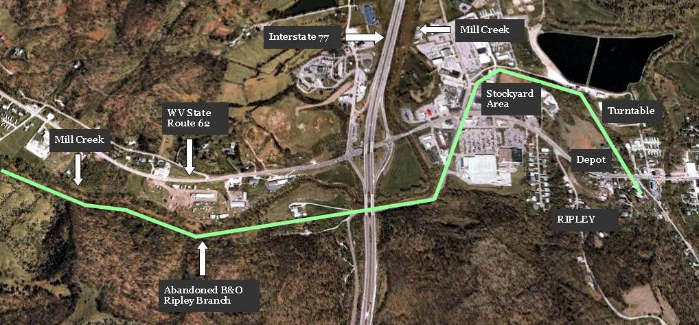
The railroad and how it entered Ripley in a Google Earth view. The only readable trace of the railroad in Ripley is at the depot itself. Expansion and development of the town westward with the coming of Interstate 77 in the late 1960s removed all traces of the railroad existence.
The railroad entered Ripley following the plain of Mill Creek on an arc (fish hook) At the end of this arc was the Ripley depot with the track extending shortly past and crossing Main Street before ending as a stub. On this stub just past the depot was a switch that connected to a track that ran on the opposite side of the depot. This enabled the depot to handle both passengers and freight. In the area to the west of the structure was a turntable used to turn steam locomotives to face the return to Millwood. In this vicinity is where the Ripley Livestock Sales would load cattle on railcars and sidings to serve the shippers that used the B&O.
|
The Ripley my father knew as a young man. This 1933 Sanborn map is remarkable because it records for history the track layout at town center Ripley. Highlighted in purple for clarity, the turntable is visible at upper left as are the sidings at the depot and shippers to the immediate west. Two prominent shippers, Pinnell and Pfost Planing Mill and the Jackson County Grocery Company, are listed trackside. Map courtesy Library of Congress
In 1948, B&O listed four remaining shippers on the line at Ripley. The largest and longest standing was Ripley Livestock Sales serving the region as the hub for the livestock rail market and was served along with S. G. Starcher, and Standard Oil on company owned track. The Jackson County Grocery was served by a spur that it owned.
Noteworthy of mention in the B&O listing is the exclusion of the Pinnell and Pfost Planing Mill shown on the Sanborn map above. Perhaps by this date it had changed names, shut down, or ceased shipping by rail during the years since 1933. B&O also recorded in 1948 that Ripley was still a coal, water, and livestock servicing point. |

|
This is believed to be an early 20th century image of the Pinnell & Pfost Planing Mill. The operation appears to be on a hillside--perhaps on the opposite bank of Mill Creek--rather than at the site indicated on the 1933 map above. Perhaps the facility had reloacted by that date that further research need confirm. Image courtesy Dollie Staats Kerns
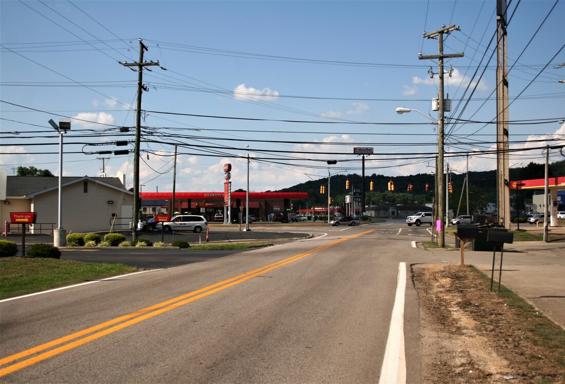
The arrival of Interstate 77 during the late 1960s forever transformed the region west of the old town center of Ripley. With the addition of Exit 38, commercial development ensued in its wake near what is now the Miller Drive sector and removed all traces of the railroad in this area. In addition, the construction of the Ripley Water Plant is located on the site once occupied by the turntable.
Ripley...1951 |
Ripley...2003 |
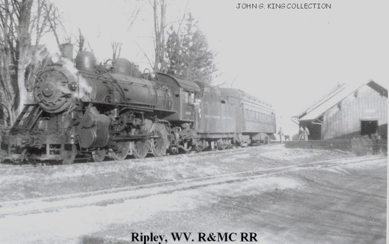
This wonderful photo freezes a moment in time during the twilight of steam on the railroad. The train has just arrived in this 1951 scene which captures the Ripley depot in full bloom as a passenger and freight station. Richard J. Cook photo/ John G. King /Dan Robie collection
|
This 2003 view of the Ripley depot is from nearly the same vantage point as the image at left. The integrity of the depot has remained relatively unchanged throughout the years. Dan Robie 2003
|
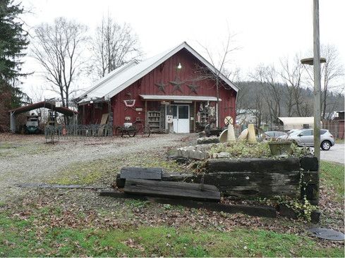
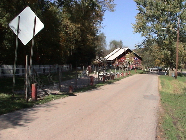
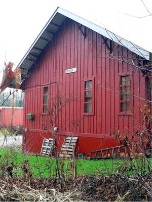
The Ripley depot as it appears today. The structure itself is relatively unchanged and has been the home of different businesses throughout the years. Mill Creek Trading Company presently operates here selling collectables and antiques. It is the last apparent reminder that a railroad ever existed at Ripley. Dan Robie 2011
|

View looking from the depot towards Main Street. Right of way is where trailer is parked. The railroad continued across Main Street for a short distance where it was stub ended. Dan Robie 2011
|
My father retained a fondness for Ripley that remained intact for his lifetime. His memories of the railroad here were of the depot, the turntable, and the seasonal livestock trains and loading. He also recalled the tragic death of a young boy during the 1930s who had fallen into the turntable pit and drowned after it filled from heavy rains.
Then...Ripley Depot 1951 |
Now...Ripley Depot 2019 |

In a scene from 1951, B&O Ten-Wheeler #2020 has been spun on the turntable and prepares to depart Ripley on the run to Millwood. The track diverging to the left served the opposite side of the depot. Richard J. Cook photo /courtesy Allen County Museum All rights reserved
|
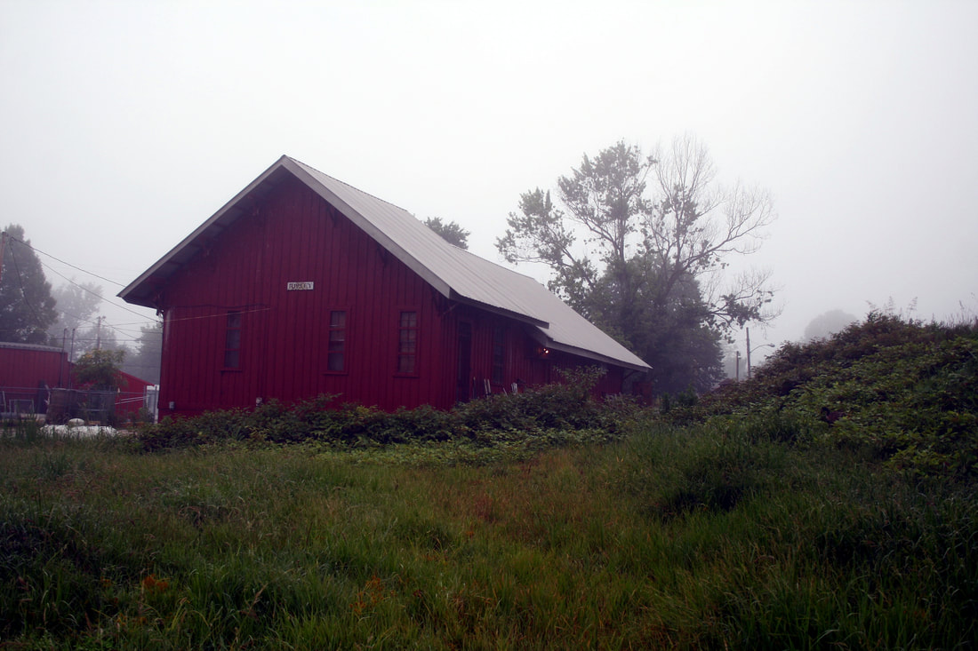
Through the foggy mist of time is the depot as it appears 68 years later from the exact perspective of Mr. Cook's photo . Aside from the obvious absence from the railroad, the depot is essentially the same excepting for roof work and chimney removal. Dan Robie 2019
|
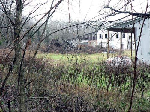
Time can be cruel to the historian researching the past with Mother Nature and development as the adversaries. Today, the only remaining trace of the railroad in Ripley is the depot area itself. The remainder of the right of way elsewhere has been lost to commercial development throughout the years.
Above: The rear of the depot as it appears today. A nice touch with the "Ripley" sign still on the rear. Dan Robie 2011
At right: A view from the vicinity of where the turntable was located. Area in distance was the site of the Pinnell and Pfost Planing Mill and the Ripley stockyard in the distant past. Dan Robie 2011
|

It is inconceivable that a turntable and sidings were once located near here. Mother Nature has reclaimed the area to the rear of the depot extending along Red Wing Lane. Dan Robie 2011
|
2019 Update: Although the outward appearance of the depot appears reasonably sound it has been reported that the building suffers from termite damage to its sub-structure. The future of this landmark structure and last tangible evidence of the railroad existence in Ripley at this writing is ominous.
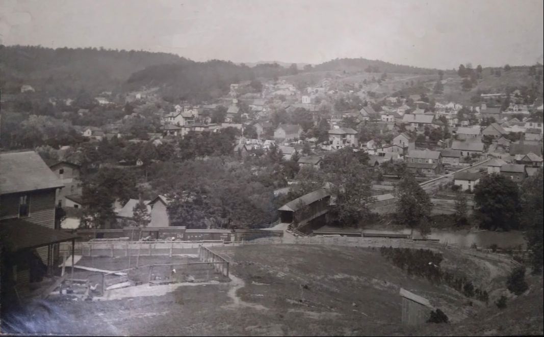
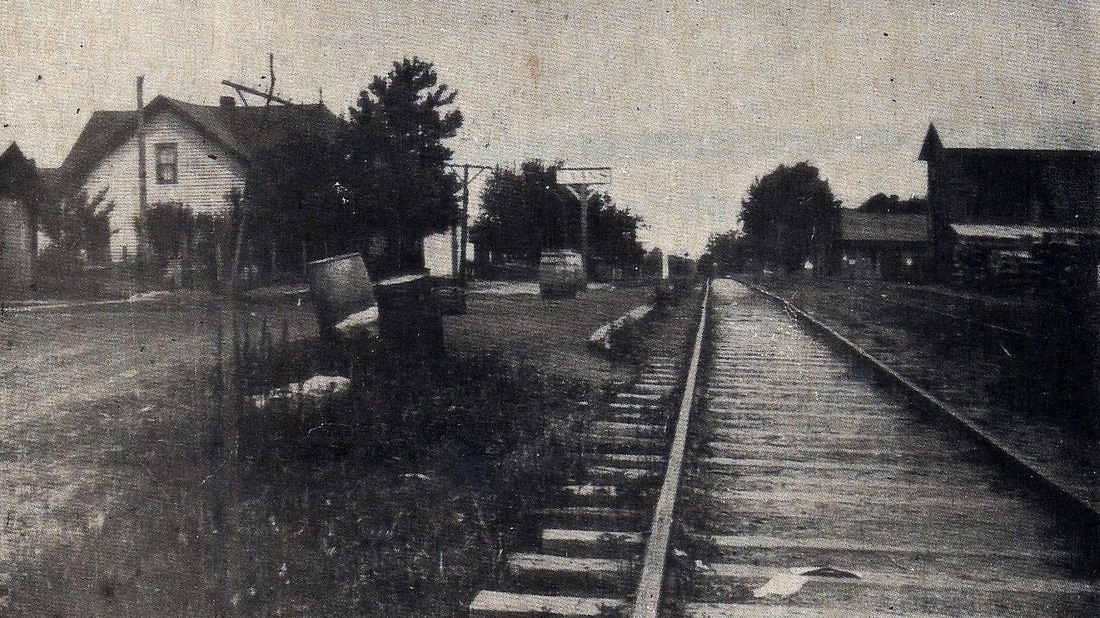
A remarkable photo from the early 1900s taken from the hill above Old Stone Ridge Road. This view looks into old-time Ripley and the courthouse is visible in the distant center. In the foreground is the covered bridge connecting Bridge Street with Klondyke Road where the railroad extension from the depot ended---note the boxcars. Image courtesy Dollie Staats Kerns
Ripley 1888 and Circa 1900...
|
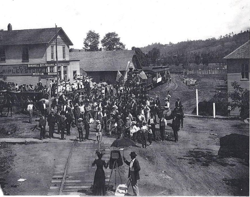
This photo was previously identified as the first train in Ripley. Further research has determined that it is a July 4th celebration after the turn of the century. Susan King, who gained notoriety photographing the last public hanging at Ripley, is seen capturing this event. Note the orientation of the railroad depot. It was later repositioned in 1914 and remains the same today. Photo courtesy of Mike McGrew.
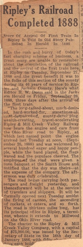
At left: A reprinted newspaper clipping describing the week of the arrival of the Ripley & Mill Creek Valley Railroad in 1888. Courtesy of Jackson Herald/ Maxine Lanfried
|
...Ripley 2011
More than one hundred years later, the same vantage point of the early 1900s scene above. Aside from the depot--although repositioned---and the profile of the hills in the distance, all else has drastically changed. Dan Robie 2011
Credits
Betty Robie Briggs
Richard J.Cook/Allen County Museum
Charles Fletcher-“B&O RR History-Ripley, WV”
Charles Fox
Jackson County Historical Society
Jackson County Public Library
Dottie Staats Kerns
John P. Killoran/Bob Withers collection
John G. King
Maxine Landfried
Library of Congress
Mike McGrew
Gary Mittner
Kevin Painter
Joe Pickens
Michael Poe
Keith Pride
Rhod Mills Rails and Relics
Ripley WV Historical Page
S.E. and Mildred Robie
Mike Ruben
David Sommer
WV Pioneers.com—“Pioneers of Jackson County” by John House
West Virginia and Regional History
Bob Withers- “Last Stand of the B&O Ten-Wheelers” TRAINS Magazine June 1988
The initial publishing date for this page is 12/17/2011.
Reader Memories
It has been both humbling and heartwarming the number of comments and inquiries that I have received about this B&O Millwood to Ripley feature. Of the historical pieces on the WVNC Rails page thus far, the number of views is among the highest. With the historical family ties to this piece, there is an extra sense of gratification to read the inquiries and memories of this small branch line railroad that existed many years ago. I know Mom and Dad would be pleased.
This section has been added to the page to enable readers to share any memories of the railroad. If any reader wishes to contribute, simply notify me via the Visitor Feedback Page and the comments will be posted verbatim and credited here. If a reader provides any direct data about the railroad and/or operations including images, it will be inserted into the main article per their permission.
Dan Robie
July 2013
"I spent the summers with my grandparents Noah and Anna Scarberry who lived in Angerona. Their home was between the two trestles on Angerona Road. There was a small platform behind their house where we would stand for the train to stop to take us to Cottageville to do our shopping and to visit my grandmother's sister whose husband was the school superintendent. This was about 1958 when I was about ten years old. I have fond memories of that and I remember when the train ran the engineer would blow his whistle when he would get close to the house. I would run out into the backyard to see the train and I remember who I think was the engineer would throw Cracker Jacks to me and I suppose to the other children along the line. I have told that story to many people and have wondered many times over my adult years what became of him. In my own way I still love that man. I also remember the freight train running at night and shaking the whole house when I was in bed. Our house was no more than 20 feet below the tracks. I still remember how it felt to walk the tracks and play on the beams under the trestle, once as the train went above us. We were young, brave, and very dumb kids at times. If you have any idea which man in the picture was the one who tossed me the treats I would be very grateful. I was telling my wife about the general store in Cottageville and the grist mill that we used to sneak into, looking for pictures when I found your article."---Terry Williams
"I told my mother who is now 85 years old about your website and she wanted you to know she went to school at Walnut Grove School, Cottageville junior high, and high school. She said she went to school with some Robies in her words. She also took the train to school in Cottageville. Her parents and two of her three brothers are buried in Otterbein Cemetery. She also wanted to say that the hobo's that would jump the train and walk the tracks knew that if they were hungry they could stop at my grandmother's house for a meal, she was known to everyone in that area as Aunt Annie. The tracks were about 20 to 30 feet up a small hill behind the house. If you are interested the Ravenswood News published an article " Angerona: Once a Thriving Town" April 23 1978. My grandmother is also in a picture as a very young and beautiful women. Her home was just to the left of the store that burned down in another picture"--Terry Williams on behalf of his mother
"My grandparents Noah and Anna Scarberry lived in Angerona at the crest of the grade between the two train trestles. Today there are 2 trailers that set on the property. I'm now 61 years old, as a youth we spent endless hours walking the tracks and daring each other to walk across the trestles. The train tracks were no more than 75 feet from the back of the house. The conductor would always blow the horn and throw us candy. The train traveled slow enough for my uncles to jump on and ride to Ripley. Thanks for the article, it brought back a flood of great childhood memories!"---Mike Williams