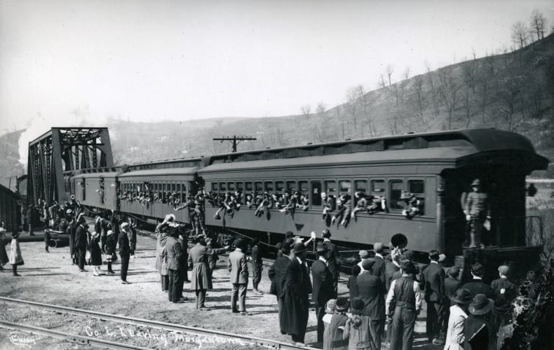
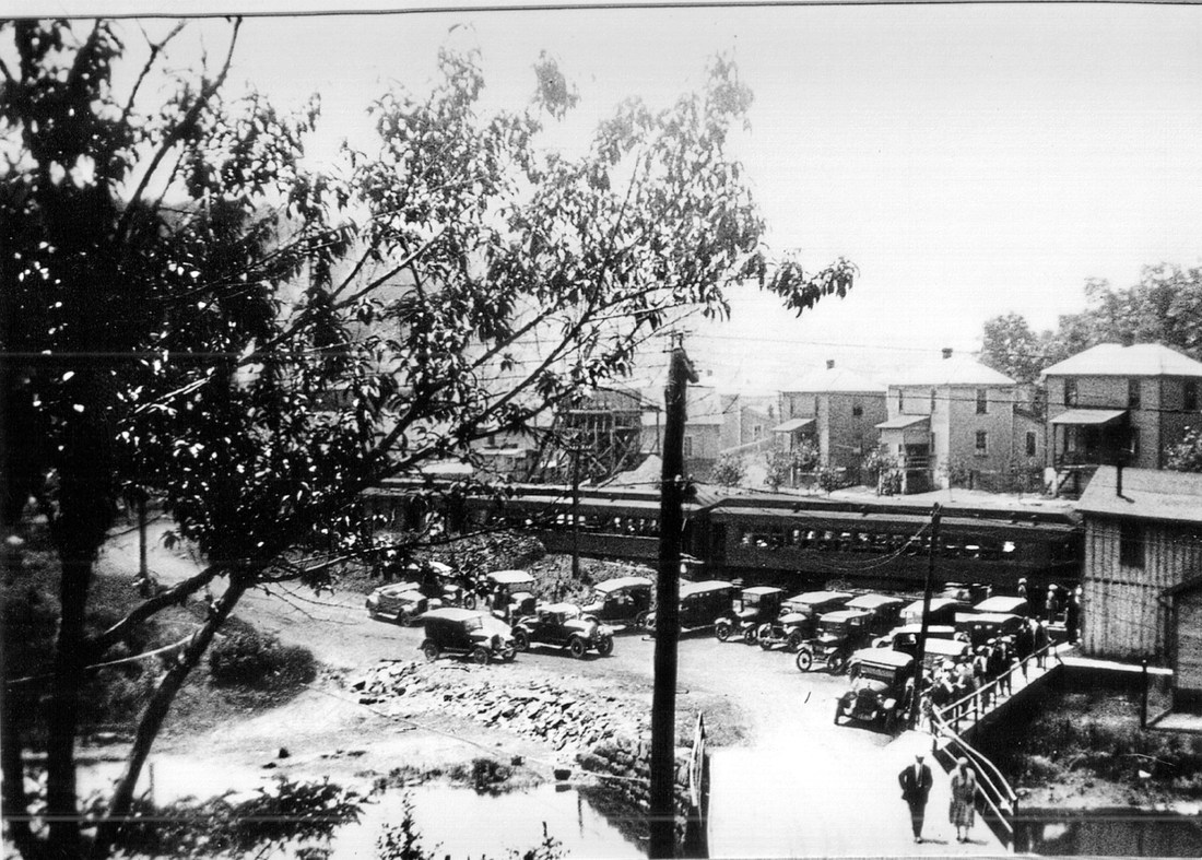
Train time along the M&K at Morgantown in 1910. Old time Morgantown was in full bloom and the era of the passenger train at its zenith as emphasized by a six car train on a secondary line. Image West Virginia and Regional History.
Morgantown and Kingwood Railroad
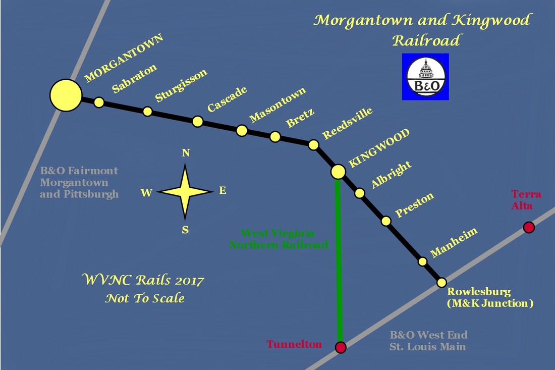
A customized map of the Morgantown and Kingwood Railroad depicting selected locations along the route and regional connections. At its western end, it connected with the Fairmont, Morgantown & Pittsburgh (B&O) at Morgantown. On the east end, M&K Junction to the B&O St. Louis main within the legendary West End mountain grades. The independent West Virginia Northern Railroad was also an occupant of the Preston County landscape.
Overview
During my years of working on and exploring native Mountaineer soil, this is among the railroads within the state seldom seen. My closest contacts with the M&K were at its end points---M&K Junction and Morgantown. In later years I would eventually cover territory in the heart of Preston County but by this time, the railroad was essentially gone. As the years passed, this route inspired interest as curiosity expanded and with it, the desire to learn more about its history.
The mere mention of “M&K Junction” to a versed historian of the Baltimore and Ohio Railroad immediately evokes connotations of a legendary place entrenched deeply in railroad annals. Of course, that location needs no full description for those familiar with its existence and the prominence it holds in B&O history. Situated in the Cheat River Valley at Rowlesburg, WV, it is at the bottom of a topographical bowl where the only way out of town is uphill. For generations, M&K Junction was a helper station during both the steam and diesel eras that signified the addition of power for trains to surmount the four storied grades---Newburg, Cheat River, Cranberry, and Seventeen-Mile---of the B&O West End. But beyond the lore, M&K Junction was what it implied—a connection with a secondary line that traversed the plateau and valleys of Preston County. Continuing westward into Monongalia County, the railroad reached its terminus at a junction with the Fairmont, Morgantown, and Pittsburgh Railroad (B&O) at Morgantown, WV. This line, the Morgantown and Kingwood Railroad, was constructed as an independent road but later absorbed into the B&O system.
Perhaps the Morgantown and Kingwood Railroad is not as prominent in B&O history as other rail corridors but this fact does not diminish the importance or interest of its existence. For all its 48 miles of length, this line packed a scenic and economic punch concurrent with the changes in both as the line traversed Monongalia and Preston Counties.
Hikers on the present day Deckers Creek Rail Trail can walk the abandoned right of way between Morgantown and Reedsville and savor the scenery that train crews and passengers once did before them. Students of history see few remaining signs of a region that once flourished with business but can appreciate and envision what once was. Whether it is the remnants at Oak Park or perhaps the ghostly remains of coke ovens at Bretz, traces of yesteryear survive whether subtle or profound. At Reedsville, one can envision a time 80 years ago when a train arrived with President Franklin D. Roosevelt and First Lady Eleanor on board to witness firsthand the New Deal project that was Arthurdale. Whether they appreciated the scenic splendor of the Allegheny Mountains or the turbulent rushing of the Cheat River on their trips will never be known. But thousands who rode the trains on the M&K in anonymity surely admired the changing vistas.
The route of the Morgantown and Kingwood Railroad would fulfill the mineralogist dream. Rich in coal deposits, limestone, and sand, the natural resources directly fed local industries as they processed these raw materials for heavy industry. Coal from the mines for direct shipment offline or kept within the realm of the M&K for coke making for the steel industry. Limestone shipped in its natural state or pulverized for cement at locations such as Manheim. There was sand from the Deckers Creek basin near Greer that was the foundation of the glass making industry in the Morgantown area. Above ground were the great timber stands early in the railroad history harvested for a myriad of construction purposes.
For half a century, the M&K served its purpose as a passenger corridor through Monongalia and Preston Counties while simultaneously serving as a connection to the greater world abroad. For a century, it served shippers through the course of time in which it ultimately declined into two disconnected branch lines. The western end from Morgantown withered first as heavy industry steadily declined. The east end fared longer barely remaining in service into the 21st century but succumbed as well. Today, the M&K is physically gone but will endure as a lasting legacy to the region it served and the historians left in its wake.
The addition of the Morgantown and Kingwood Railroad to WVNC Rails (January 2017) is a deviation from all that has previously come before it. For the first time, there is no documentation or photographs directly contributed by the author. All of the supporting information has originated from external sources. Also, there had been scant contact with this railroad while it existed or thorough familiarity with the region. In compiling this piece, the one regret is a lack of B&O and CSX images particularly between Kingwood and M&K Junction. If a few such images can be acquired in the future, they will be inserted into the work. All factors considered, it is hoped this humble effort will suffice.
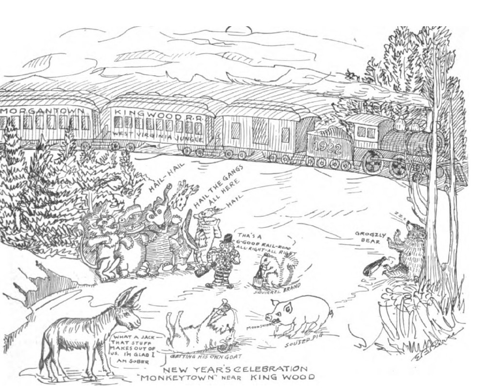
This drawing by a B&O employee of the M&K Division was submitted to the Baltimore and Ohio Magazine in 1914.
Condensed History
By the last decade of the 1800s, railroad construction had saturated the northern West Virginia region to tap the vast quantities of natural resources available. Preston County was no exception--within its boundary were timber stands and coal deposits. To the east, the Baltimore and Ohio mainline traversed the mountains moving west to Grafton and beyond. On the western flank, the Fairmont, Morgantown, and Pittsburgh Railroad (B&O) had been completed during the 1880s developing a corridor for coal traffic to feed the rapidly developing steel industry of the Pittsburgh region. Within Preston County itself, a narrow gauge railroad named the West Virginia Northern had been constructed connecting Kingwood to the B&O mainline at Tunnelton. This small railroad, completed in 1897, at first was a timber hauling line but expanded to coal with a conversion to standard gauge track. It was only as the calendar was soon to turn to a new century that another railroad would be built in Preston County. Its objective was twofold--tap the natural resources for revenue and create a through route with connecting endpoints to the greater rail network.
Discussion about constructing a railroad through Preston County originated in 1887 at Reedsville. Six men--Colonel Felix Nemegyei, Judge John Hagen, J.C McGrew, George C. Sturgiss, J.W Sturgiss, J.W Guseman, and John Straus--were the driving effort behind this endeavor. The original route proposed was from Grafton north through Preston County and extending into Pennsylvania. The chief objective was to tap the rich coal fields of Preston County as the primary source of revenue. This undertaking, coined with the name West Virginia Railroad, initially began as planned with the route survey completed by Colonel Guseman. But inexplicably, this railroad would never see a construction phase. Interest and finances waned with the holdings sold to Robert Pitcairn of Pittsburgh. Again, this change yielded no results. Mr. Pitcairn did not honor his contract and construction of a railroad was dormant once more.
Ultimately, a charter was secured for what would become the Morgantown and Kingwood Railroad on January 10, 1899. The ambitious force behind this effort was none other than George C. Sturgiss who was among a group of men previously intending to build the railroad. Focusing on construction from Morgantown through the Deckers Creek valley, the company was organized in 1900. Unfortunately, the saga of building the railroad would undergo yet another transition. Although Sturgiss did begin the survey and acquisition of right of way, he would not realize its construction. In 1902, Stephen B. Elkins purchased all holdings of the Morgantown and Kingwood Railroad and it was under his ownership that finally, tracklaying would begin. The Elkins leadership was instrumental because it also owned the Elkins Coal and Coke Company---the addition of a railroad obviously mutually beneficial to both entities.
|
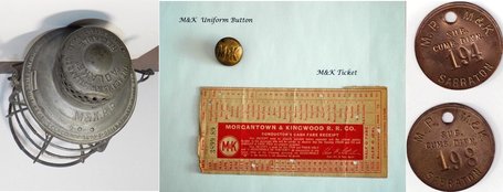
Various Morgantown and Kingwood Railroad memorabilia: lantern, uniform button, ticket stub, and brass tool tags. Courtesy Jim Brown
|
The construction of the Morgantown and Kingwood Railroad was completed in phases. In 1903, the line had been completed 15 miles from Morgantown to Bretz. Three years later, another 14.4 mile extension Kingwood was built. The following year in 1907, the railroad was further extended 18.4 miles from Kingwood to Rowlesburg. Once completed, the M&K total length was 47.9 miles and at its end points, connected with the Fairmont, Morgantown, and Pittsburgh Railroad (soon to be B&O) at Morgantown and to the east, the B&O mainline at Rowlesburg.
|
The railroad was headquartered at Morgantown and to the east, servicing facilities constructed at Sabraton. It rostered three passenger and eleven freight locomotives and maintained a fleet of 360 freight cars of which the majority were of steel construction. Quickly, the railroad prospered from the rich natural resources to be found along the route---coal, silica sand, and limestone. Coal mines were opened, coke ovens constructed, and regular passenger service flourished on what became a bridge route between major B&O lines. By 1920, B&O had entered the picture and leased the railroad before acquiring it outright in 1922. Under B&O ownership, the M&K was integrated into its vast rail network and created an auxiliary route between the primary St. Louis mainline at Rowlesburg and the FM&P route through rich industrial territory between Fairmont and Pittsburgh. Thereafter, the B&O referred to the route as the M&K Branch.
|
For a half century, the B&O operated the M&K Branch in its entirety. The industry located along its route continued to generate strong revenue but it was the years following World War II that decline gradually began. As resources dwindled, the number of mines decreased. The post war years witnessed the improvement of highways and the influx of automobiles and by1953, the era of the passenger train on the M&K ended. By the 1970s, industry had declined to a level that B&O filed for abandonment the section of railroad between Reedsville to the east of Kingwood. Once the line was severed, the M&K existed as two separate stubs---the west end served from Morgantown and the east end from Rowlesburg. In the 1980s, heavy industry disappeared on a large scale and the west end of the M&K was abandoned from Morgantown to the endpoint near Reedsville. So rapid was the decline that once CSX, successor to the B&O, had taken control that the former FM&P route between Fairmont and Point Marion, PA was filed for abandonment in 1989. By the change of the millennium, the only existing segment of the M&K was from Rowlesburg to Albright along the Cheat River. But this, too, was on borrowed time. In 2003, CSX filed to abandon this section of railroad and the original Morgantown and Kingwood Railroad shortly thereafter vanished from the landscape. Today, the right of way from Morgantown to Reedsville is the Deckers Creek Rail Trail. At the time of this writing, a group called the Friends of Cheat River has successfully acquired right of way between Rowlesburg and Caddell for rail trail development.
|
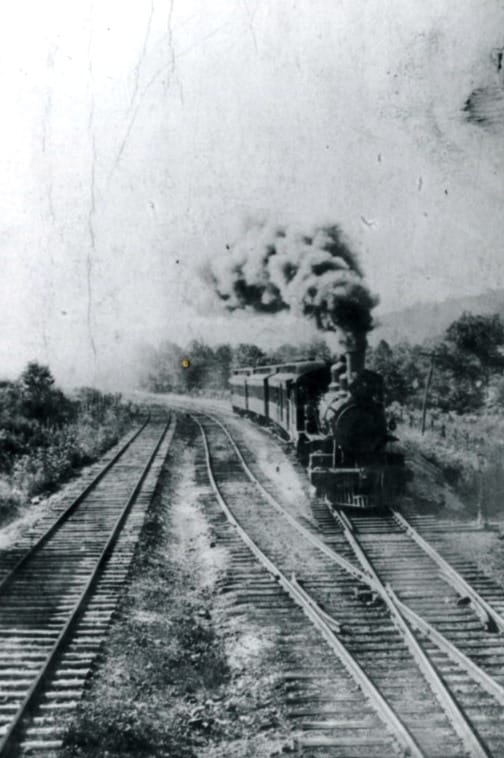
Photo identified as an M&K passenger train circa 1910 although this is not confirmed. Image West Virginia and Regional History.
|
Operational Notes
The M&K headquarters was located in the post office building at Morgantown and locomotive and car repairs were conducted at the company shops in Sabraton east of Morgantown. Operational practice of the Morgantown and Kingwood Railroad was established early and remained basically in effect after its acquisition by the B&O. It operated primarily in a west to east manner with the greatest number of carloads interchanging at Rowlesburg. This was particularly true in regards to the coal and coke traffic. Most of this volume moved to the industrial region of Baltimore in conjunction with the steel industry. General manifest traffic, substantially less in quantity, also moved in this fashion although a percentage utilized the M&K at Morgantown and especially that which was local to the area. Passenger service consisted of scheduled trains that moved between Morgantown and Rowlesburg. These not only fulfilled the need for travel between the communities scattered along the M&K but provided connection to the larger rail network at its endpoints.
For nearly two decades, the Morgantown and Kingwood Railroad operated as an independent entity. These years emphasized the route in its entirety with freight traversing the breadth of the route. Sabraton, as the focal point with the locomotive servicing and shops, was central as was its yard. Passenger operations were at the pinnacle during the M&K years as trains ran between Morgantown and Rowlesburg while serving all the stops between. For a railroad less than 50 miles in length, it packed an industrial punch with the number of mines, coke ovens, and sand/ stone shippers it served. Manifest was less prevalent but there were shippers along the route that received the boxcar as well.
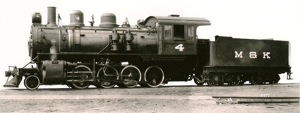
The Morgantown and Kingwood operated with light to medium steam locomotives. Its roster was populated with 4-4-0 Americans, 4-6-0 Ten-Wheelers, and 2-8-0 Consolidations and thirteen of these locomotives deemed by B&O as serviceable power were incorporated onto its roster. They are listed as follows:
M&K 4-6-0 #2 became B&O Class B-55 #163 (retired 1947)
M&K 2-8-0 #5 became B&O Class E-39 #415 (retired 1947)
M&K 4-6-0 #14 became B&O Class B-56 #164 (retired 1946)
M&K 2-8-0 #6 became B&O Class E-39 #416 (retired 1947)
M&K 2-8-0 #3 became B&O Class E-37 # 413 (retired 1946)
M&K 2-8-0 # 8-13 became B&O Class E-40 #417-422 (retired 1938)
M&K 2-8-0 #4 became B&O Class E-38 # 414 (retired 1939)
M&K 4-4-0 #7 became B&O Class G-18 #630 (later #834) (retired 1936)
Turn of the century steam locomotives were clean---relatively free of external piping that would appear on later larger models. These three M&K 2-8-0 Consolidations were both handsome and efficient and all survived into B&O ownership. Images Jim Brown collection.
When B&O assumed operations of the line as its M&K Branch in 1920, the route continued to operate in a similar fashion and primarily with its passenger operations. As an example, a B&O Timetable from 1927 lists three trains on the M&K: (1)Train #42 from Morgantown to M&K Junction daily except Sunday with a coach only (2) Train #44 Morgantown-M&K Junction daily with coach only and (3) Train #646 Morgantown to M&K Junction Saturday only. Oddly, no eastbound counterparts for these trains are listed which leads one to assume they returned under the same symbol. (This will be clarified if additional information is located). By the 1930s, the line was down to two trains per day and in the final years, the use of Brill motor cars until service ceased in 1953.
Freight operations by B&O in the earlier years emphasized the M&K as a secondary route connecting the B&O mainline at Rowlesburg with the FM&P at Morgantown but over the course of time, it began to operate as a true branch line. The volume of traffic continued to move east whereas the remainder moved to or returned from the west at Morgantown. As a common practice still in effect during the 1940s, B&O would dispatch trains from Morgantown and M&K Junction and they would meet at Bretz. Here, the trains would trade cars and use the wye located here to turn the power. An analysis of this practice indicates that B&O attempted to run the loads downgrade while returning empties upgrade.
The first significant change and a harbinger of the future was the decision to abandon approximately 12 miles of the line during the early 1970s. The shipping base between Reedsville and Kingwood had evaporated and rendering the decision easier was the fact that this section of line was the toughest operationally. Crooked and steep, B&O opted to abandon this stretch of line which split the remaining M&K in two sections. Hence, Morgantown to Reedsville was operated from the west and M&K Junction to Kingwood from the east. By the 1980s, the western end of the M&K was in decline as heavy industry vanished from the route. At the end of the decade, not only was the west end of the M&K in jeopardy, but the FM&P route along the Monongahela River as well. Both were filed for abandonment and the track removed in the early 1990s. At this time, the only surviving section of the M&K was from M&K Junction to Albright but at the end of the century, fate sealed its demise. The mine at Albright closed as did the mine at Preston which effectively ended service. CSX filed for abandonment of this section in 2003 and the track was subsequently removed to M&K Junction.
The first significant change and a harbinger of the future was the decision to abandon approximately 12 miles of the line during the early 1970s. The shipping base between Reedsville and Kingwood had evaporated and rendering the decision easier was the fact that this section of line was the toughest operationally. Crooked and steep, B&O opted to abandon this stretch of line which split the remaining M&K in two sections. Hence, Morgantown to Reedsville was operated from the west and M&K Junction to Kingwood from the east. By the 1980s, the western end of the M&K was in decline as heavy industry vanished from the route. At the end of the decade, not only was the west end of the M&K in jeopardy, but the FM&P route along the Monongahela River as well. Both were filed for abandonment and the track removed in the early 1990s. At this time, the only surviving section of the M&K was from M&K Junction to Albright but at the end of the century, fate sealed its demise. The mine at Albright closed as did the mine at Preston which effectively ended service. CSX filed for abandonment of this section in 2003 and the track was subsequently removed to M&K Junction.
|
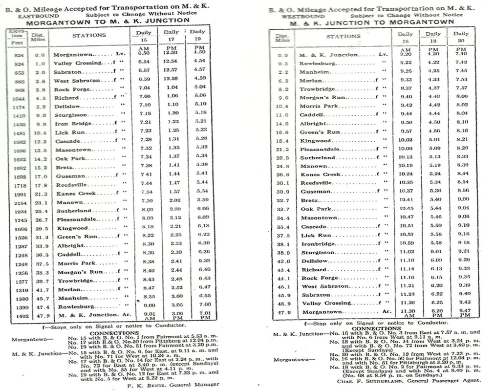
Passenger timetable for the Morgantown and Kingwood Railroad circa 1915. Also listed are connections with B&O trains at Morgantown and Rowlesburg.
|
As of 1930, B&O utilized three train order stations on the M&K Branch which were located at Sturgisson, Masontown, and Kingwood. These were gone by the end of the 1950s. As of 1948, the following telegraph offices were still in operation: Sabraton, Sturgisson, Masontown, Reedsville, Manown, Kingwood, Albright, Mainheim, and M&K Junction. A decade later, Sabraton, Sturgisson, Manown, Albright, and Manheim had been closed. Signaling and train movements were controlled by the use of semaphores and track warrants (orders). By the later years and especially after the M&K was split into two separate sections, it would often be a single train (local) working the remaining industries. In the case of the east leg from M&K Junction, symbol coal loads and empties to and from Preston and Albright which remained in effect during the CSX era.
|
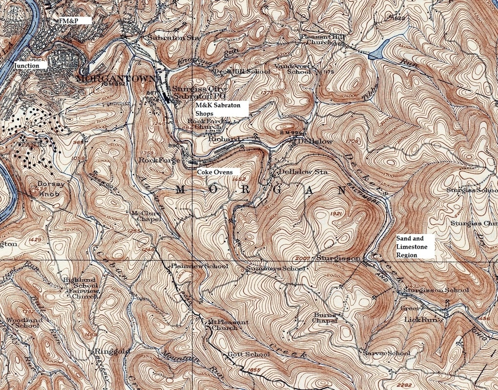
The topography of the Morgantown and Kingwood Railroad was a profile in traversing the mountainous regions flanking eastern Monongalia County and east of Reedsville in Preston County. Beginning at Morgantown, the railroad gradually ascended the Deckers Creek watershed until a point east of Richard. Here, the railroad entered a loop to gain elevation along the bank of a tributary ascending to the community of Dellslow (Station). Moving east, the climb continued gradually as it crossed into Preston County and the proximity of Cascade. The upgrade continued slightly until reaching the plateau near Bretz. At this point, the contour was essentially level with minor variances until east of Reedsville. Here, the railroad briefly followed Kanes Creek on a slight upgrade until reaching its summit at Manown.
East of Manown, the railroad began a gradual descent through the communities of Sutherland and Pleasantdale and west of Kingwood, entered a loop around South Fork Creek that began the most crooked stretch of the route. East of Kingwood, the track paralleled Green Run whereupon it entered another loop centered with the Elkins Tunnel—the only one on the M&K—and continued to move downgrade towards the Cheat River until reaching Albright. At this point along the Cheat River, the railroad paralleled it upstream on a gradual ascent until reaching M&K Junction (Rowlesburg).
Railroad Elevations (several are official town elevations)
Morgantown---825 Morgan Mines--1755
Sabraton---839 Manown---2156
Rock Forge--922 Sutherland--1936
Dellslow---1176 Kingwood--1814
Greer--1459 Albright---1291
Cascade---1651 Caddell---1248
Masontown----1683 Preston---1281
Bretz---1693 Manheim--1384
Guseman---1701 M&K Junction--1406
Reedsville---1720
From the table of elevations, the railroad experienced dramatic changes in elevation on both the east and west slopes in relatively short distances. Grades in these regions reached a 2% gradient if not in excess at specific points. B&O, in its operational practices, utilized gravity to its advantage whenever possible with the movement of loads versus empties.
Morgantown and the Route East
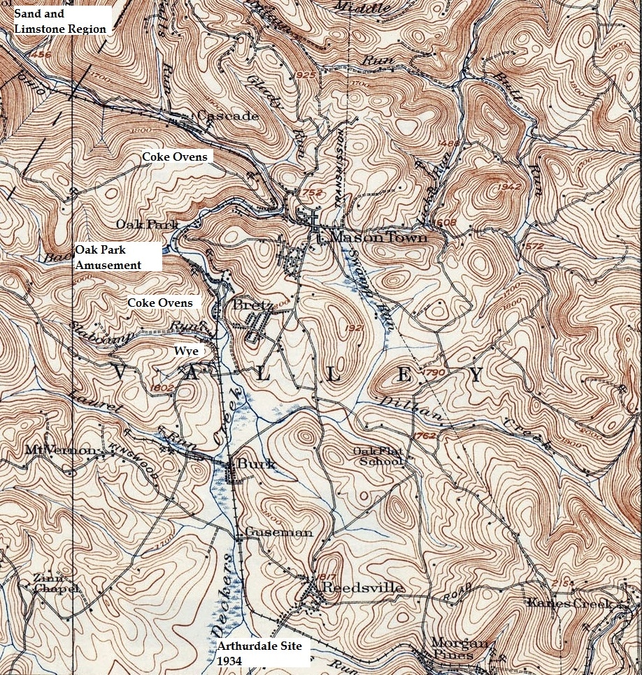
This 1931 topo map depicts the Deckers Creek valley and the Morgantown and Kingwood Railroad paralleling it eastward. Moving from its junction with the FM&P at Morgantown, the line traverses the hilly region past Sabraton to the community of Richard. East of here, the line began and upgrade assault until reaching the central plateau region of Preston County.
Morgantown
The railroad first touched the east bank of the Monongahela River at Morgantown with the arrival of the Fairmont, Morgantown, and Pittsburg (no "H") in 1886. This created a connecting route to the south at Fairmont (B&O) and to the north at Connellsville, PA (B&O). The FM&P itself would be absorbed into the B&O network in 1912. Rails were laid on the west bank of the river in 1911 by the Buckhannon and Northern Railroad which eventually would become the Monongahela Railway. The third primary route and the focus of this page, the Morgantown and Kingwood Railroad, began construction along Deckers Creek in 1903.
|
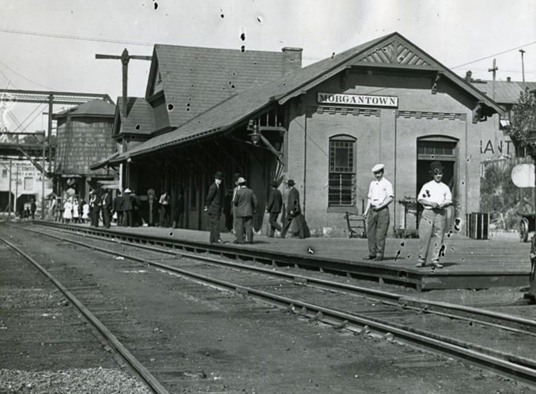
The B&O station at Morgantown during its heyday of the 1920s. This structure served both the FM&P and the M&K at the apex of rail travel. It must be train time here as people have gathered engaging in conversation never to be known as they await its arrival. Image West Virginia and Regional History
|
It is 1917 and America has entered World War I. A troop train prepares to head south towards Fairmont as it straddles the Deckers Creek bridge. The track at bottom is the M&K diverging from the FM&P. A bittersweet farewell here--most of these men would return but sadly, some would not. Image West Virginia and Regional History
|
Contemporary times have completely transformed the image of Morgantown. The immediate connotation is that of West Virginia University and the environment and affiliations of a college town. And although associated with WVU for more than a century, the story of Morgantown is not complete without understanding its position during the great industrial era and how prominent the railroad once was. Centrally situated in a vast belt bordered by the northern West Virginia coal fields to the south and the sprawling steel manufacturing base of the Pittsburgh region to the north, Morgantown itself was a center of industry.
|
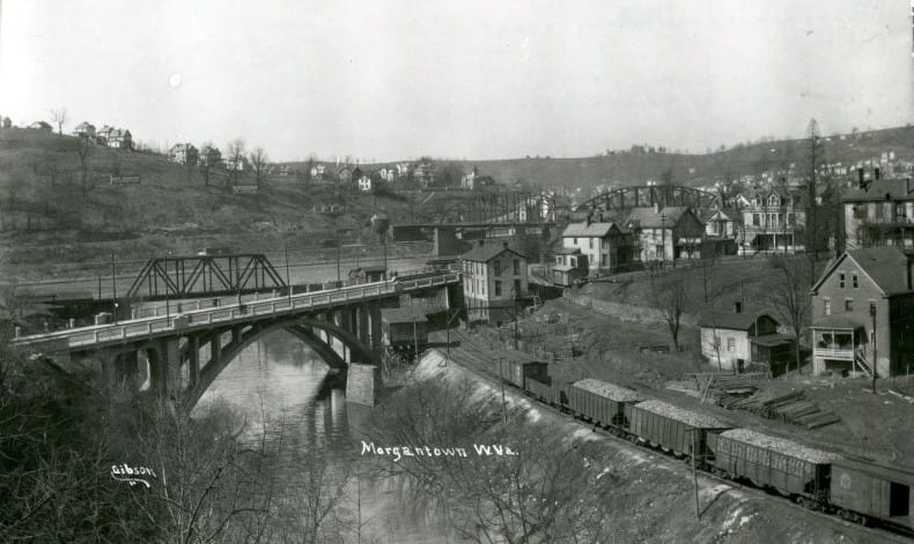
A circa 1920s scene in Morgantown at the confluence of Deckers Creek and the Monongahela River. Rail cars are on the M&K and at this time, two tracks are in place from its junction beyond the truss bridge on the FM&P (B&O). The B&O Morgantown depot is not visible but is located behind the line of sight of the two houses on the knoll. Image West Virginia and Regional History
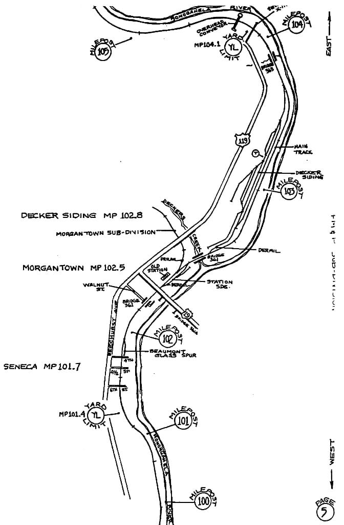
At Right: An early CSX map of Morgantown that centers on the FM&P and the junction of the M&K at Deckers Creek. Highlighted are the Morgantown yard, sidings, and mileposts. Note that the former M&K is simply "Decker Siding" at this date. Ironically, this map was drawn in 1989--the same year the FM&P was filed for abandonment. Map Bernie Beaver/CSXT
|
Morgantown, both during the M&K and B&O eras, was an endpoint at a primary location on the railroad. It was the western gateway for travelers on the M&K to either visit or tend to business in the county seat of Monongalia County. Moreover, one can assume that students at West Virginia University rode its trains and contributed to the passenger base. But train travel to and from Morgantown primarily provided a connection to distant locations on the B&O such as Pittsburgh, Fairmont, and Clarksburg via the FM&P.
|
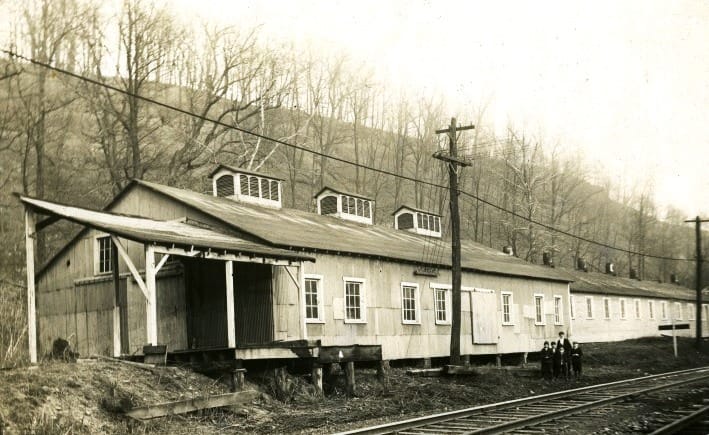
This broom factory was an early shipper along the M&K at Morgantown. Location was near the Valley Street grade crossing. Image West Virginia and Regional History
|
Mid-1960s view of the Sabraton depot at the Valley Street crossing. That model of Plymouth Fury was immortalized with a female name in a 1980s movie. Image West Virginia and Regional History
|
The bulk of the Morgantown industrial region was located along the FM&P. If one includes the Sabraton area into the greater Morgantown railroad landscape, then the number of shippers increases accordingly. However, the M&K was no less important because of what it transported to Morgantown. The Monongahela River valley was laden with the glass making industry and the near pure silica sand mined at Greer and elsewhere along the M&K provided the raw material for the industry. This high quality sand also moved south to the B&O mainline corridor in the Clarksburg area to support the glass manufacturing base there. Although coal and coke moved predominately eastward on the M&K, quantities also moved west into Morgantown for distribution to the steel industry northward to Pittsburgh.
Contained within the Morgantown city limits as it was in 1948, B&O listed these shippers on the M&K: The Great Atlantic & Pacific Tea Company and a team track for any number of shippers using trackside pick up by truck. This track was located just east of the junction with the FM&P.
Sabraton Shops and Industry
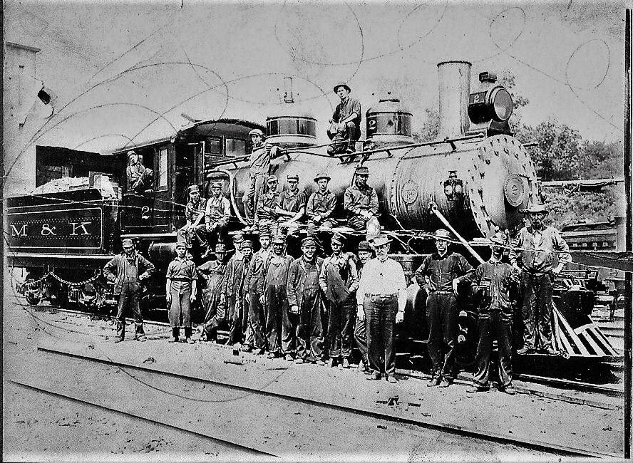
The Sabraton shop crew is starboard side for this group portrait with M&K #2 circa 1910. It was common practice for photographers to pose employees with locomotives for portraits into the early 1900s. Image Jim Brown collection
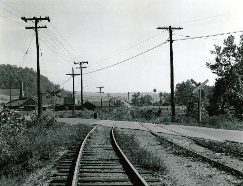
Sabraton is approximately two miles east from the M&K junction with the FM&P. It was here that the Morgantown and Kingwood Railroad located its repair shops for locomotives and rolling stock as to include passenger cars. Formerly known as Sturgiss City, the name was officially changed to Sabraton during the early 1900s. The M&K also utilized this location as a freight yard—the only one of consequence located on the 47.9 mile route. Sabraton was also a telegraph station along the M&K with call letters SA. Other assets at this location included a wye, water tower, and but detailed information is sparse on this facility---it appears that B&O continued to use the shops in some capacity through the years and the yard also remained in use. Topographical maps circa 1970, however, do not include any of the shop buildings still in existence but do indicate remaining yard tracks. If clarification or correction can be obtained, this information will be updated. In terms of the railroad right of way here, the line crossed from the north side of Deckers Creek to the south bank where it remained throughout its eastward course.
|
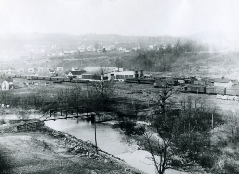
A view of the Sabraton shops and yard from the opposite side of Deckers Creek. Photo taken circa 1920. Image West Virginia and Regional History
M&K right of way view at Sabraton circa 1915. This appears to be an eastbound view from the shop area. Image West Virginia and Regional History
|
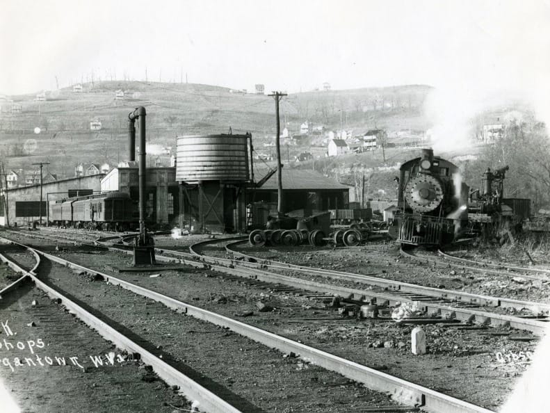
The M&K Sabraton shops as they appeared circa 1915. Service tracks with water tower are visible and the shop buildings in the distance. Image West Virginia and Regional History
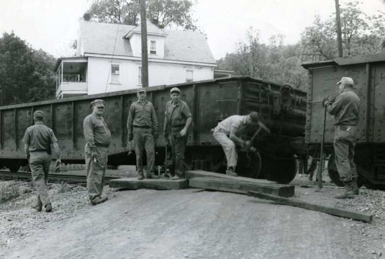
A work train is paused as crew make repairs at the Carnegie Street grade crossing. East end of Sabraton in 1966. Image West Virginia and Regional History
|
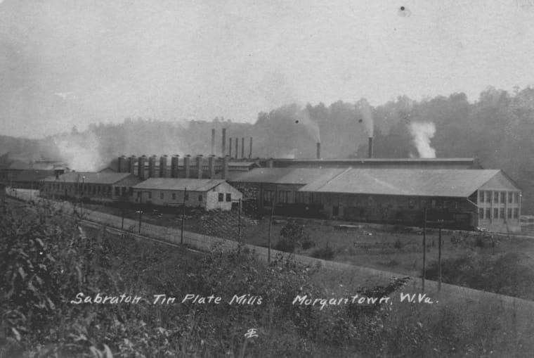
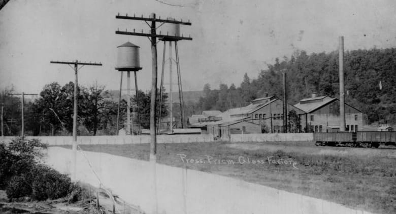
The Elkins Coal and Coke Company dominated in its impact on shipping during the early years of the M&K. One such early operation at Sabraton was its Number 5 Mine. According to West Virginia mining surveys, this mine averaged a daily capacity of 550 tons. Other large shippers located here including the Sabraton Tin Mills although it and others had disappeared by the World War II era. In its 1948 report, B&O recorded the following shippers as active at Sabraton: Miller Oil Company, Hughart Feed Company, Texas Oil Company, Pressed Prism Plate Glass Company, Sterling Faucet Company, and the Yale Mine.
|
The Sabraton Tin Mills was a large shipper for the M&K into the early B&O era. It appears to have ceased operations in the pre-World War II years as it was not listed in the 1948 B&O shipper register. Image West Virginia and Regional History
|
Another large shipper at Sabraton was the Prism Flat Glass Company. Those gondolas were used to haul sand to the plant for glass making. Image circa 1920 West Virginia and Regional History
|
East of Sabraton, the railroad moved through the community of Rock Forge. This was another industrial pocket emphasized by the coal and coke industry. As of 1948, B&O listed the Rock Forge Mine and Coke Ovens along with the Bethlehem Mine #21 as active shippers.
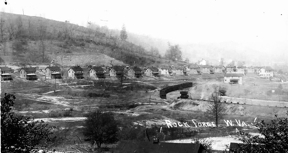
The town of Rock Forge as it appeared during the 1920s. Workers homes dominate the perspective here and the rail sidings and coke ovens are to the right. Rock Forge began the stretch of communities moving eastward that were home to perhaps the most synonymous industry along the M&K--that of coke production. Image Jim Brown collection
Richard
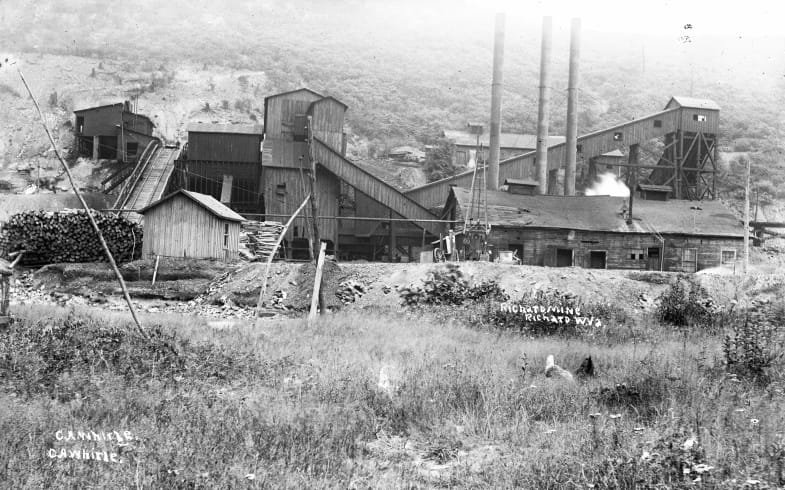
The mining camp at Richard is one that was prominent during the M&K years but had faded by mid-century. West Virginia Coal Company established a mine in 1903 of which the coal was used to create coke in the ovens previously constructed. This was the beginning of a mine history that would undergo a change of ownership on more than one occasion.
|
Richard #3 Mine as it appeared circa 1910. Elkins Coal and Coke Company was the first of several owners that would operate this mine during its life span. Image West Virginia and Regional History
|
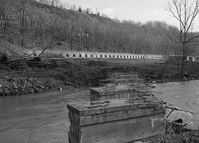
This photograph taken in 1976 shows the bridge piers from the spur that crossed Deckers Creek to the Richard coke ovens. The ovens have since been demolished. Image William Barrett/HAER
|
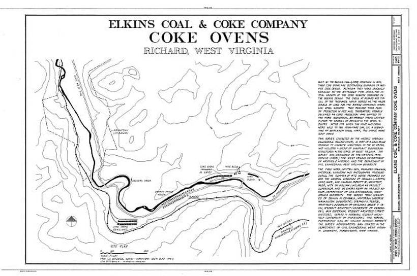
The coke ovens at Richard were located on the north bank of Deckers Creek on the opposite bank from the railroad and in some instances, are listed as a Dellslow address. A spur was constructed across the creek directly to the mine and ovens and by1906, the Elkins Coal and Coke Company had taken ownership of both the mines and coke ovens. At this time, this facility was named as the Richard #3 Mine. In 1919, the mine was acquired by the Penn-Mary Company and it was christened as Mine #21 under the new organization. It continued to operate under this ownership until at least 1929. By 1936, the Richard Mine had changed ownership yet again and was now listed as the Industrial Collieries Mine #21. Records indicate this mine operated until 1952 but inexplicably it does not appear on the B&O 1948 shippers report.
A map created by the Historic American Engineering Record of the layout of the Richard mine and coke ovens. This dates from the 1970s when research to document the area was undertaken. HAER/Library of Congress
Richard ended the urban stretch of the M&K that extended east from Morgantown. From here, the line continued upgrade to Dellslow Station, Sturgisson, and by Greer through rugged terrain as it crossed into Preston County. At Sturgisson was located the Deckers Creek Stone and Sand Company which quarried sand for glass making and construction. This was also the location for a B&O block and telegraph station with the call letters SN. Moving towards the county line near Greer were spurs branching from the main to serve smaller coal, stone, and sand operations. One of these was the Greer Limestone Company recorded by B&O in 1948. This company is still in business today albeit without rail service.
|
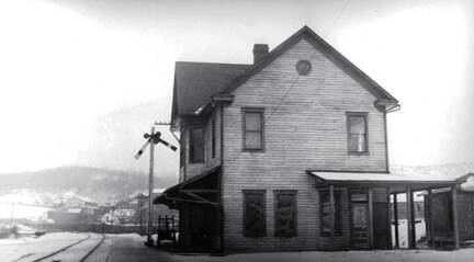
A valuation photo of the Dellslow Station probably dated from the 1920s. There was a variety of architecture used for the M&K depots as no two appear to be alike. Image Jim Brown collection
|
This appears to be a photo taken during the eastward construction of the line. Note the men and material on the new Dellslow trestle and the 4-4-0 American adds to the early flavor. Image Jim Brown collection
|
As the M&K ascended the Deckers Creek basin on its eastward trek, the character of the railroad changed from the Morgantown region. In the region east of Richard, it developed the flavor of a mountain railroad as it moved high above the creek. The area here extending to Cascade in Preston County was defined with trestles and rocky outcroppings along the right of way. A sparsely populated rural sector sprinkled with scenic charisma further personified the character.
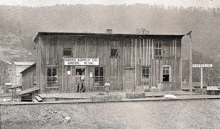
A panoramic view of Greer as it was circa 1930. The siding to the limestone quarry is at bottom with the community on the opposite side of Deckers Creek Image courtesy Jim Brown
|
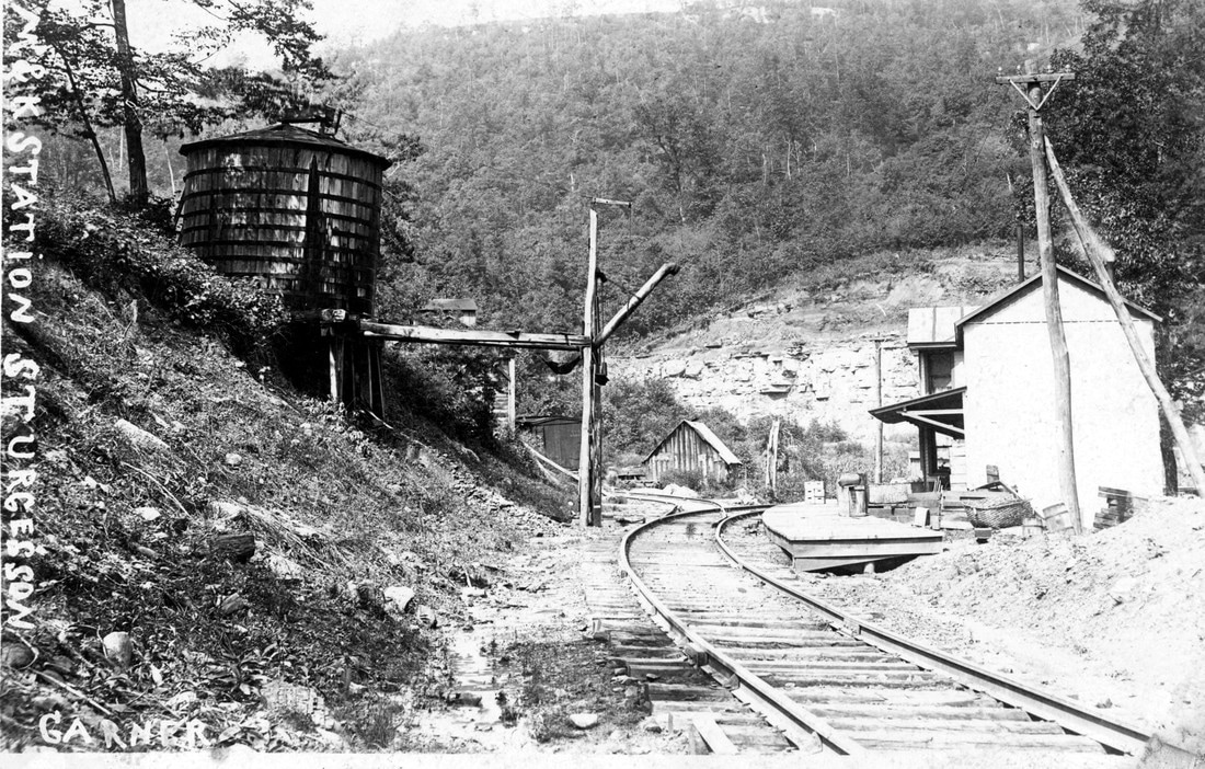
The Sturgisson depot and water tower circa 1920. All the charms of a rustic setting along a rural stretch of railroad. Image Jim Brown collection
|
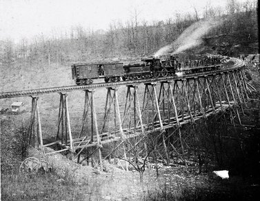
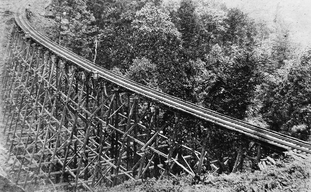
The Mountain State is dotted with colloquial and colorful place names. This impressive curved trestle spanned a divide between Greer and Cascade and was known as the Coon Hollow Trestle. It does not get any more West Virginia than that! Image Jim Brown collection
|
Plateau Region
Moving east through Monongalia County, the railroad began its upgrade ascent towards Cascade in Preston County. Continuing to parallel the Deckers Creek drainage, the topography levels on a plateau east of Bretz. The railroad basically ran on a tangent until reaching the Reedsville vicinity. East of Reedsville, the railroad continued upgrade to Manown before a long eastward descent led to the Cheat River valley.
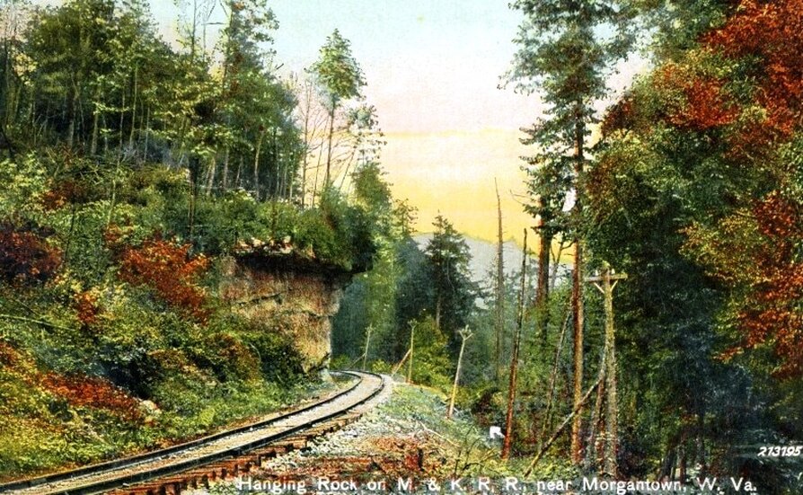
The railroad along Deckers Creek fit tight between the stream and the mountains. Defining the hilly region are rocky outcroppings and bluffs with the location at Hanging Rocks the prime example. Located along the railroad at Cascade, this scenic feature for years was a magnet for visitors. Today, hikers along the Deckers Creek Rail Trail can admire free from the worry of approaching trains. Postcard image West Virginia and Regional History.
Coking Industry
Since the coking industry factored heavily in the economic base of the Morgantown and Kingwood Railroad, it is appropriate to include a brief description here for the reader not familiar with it. In terms of West Virginia production, it was an industry that supplemented the manufacturing of steel.
The practice of making coke from coal dates to the 18th century for the manufacture of pig iron. Special ovens, called “beehives”, were constructed of block with a large opening in front that would be sealed with bricks. They were constructed in the shape of beehives with the smokestack formed at the top. As the Industrial Revolution in the late 1800s progressed, the ovens were constructed in rows to accommodate the increasing demand and typically in proximity to a mine. A basic description of the coking process is as follows: The ovens are loaded with coal and the opening then sealed with bricks. The sealing reduces oxygen in the oven and the coal bakes to nearly pure carbon form—vital for steel production. If a batch had been coked previously, the residual heat will ignite the next load. It takes approximately seventy-two hours for the coal to “bake” to carbon before it is removed and sprayed with water for cooling. Finally, it is loaded into hopper cars and shipped by rail. How surreal it must have been to see these ovens at night with a glowing effect.
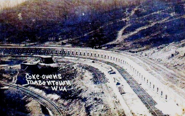
Beehive oven usage peaked by circa 1910. Newer coking methods were developed that eliminated the harsh environmental impact of beehive ovens—namely smoke and tar. But the beehive oven continued in use until the last ones were shut down at Bretz in 1981. Other notable locations of these ovens along the M&K were at Rock Forge, Richard, Cascade and Masontown.
Cascade
|
After the railroad crossed from Monongalia into Preston County, the first community touched in the Deckers Creek drainage is Cascade. Though small in size and population, a strong industrial presence existed here. A mine, power plant, and coke ovens generated substantial carloads on the M&K for many years. As most of the coal and coke production in the region was owned by the Elkins Coal and Coke Company, the operation at Cascade was an exception. It was under the domain of the Preston Coal and Coke Company.
The coke ovens of Cascade remained an anachronism of time defying an industry that had long ago adapted to newer methods of production. Beginning in early in the 1900s, the coke ovens of Cascade generated carloads for the M&K and B&O until they cooled for the final time in 1974. Today, the Deckers Creek Rail Trail passes by a reclaimed area where men once toiled in the smoky environs of this arduous industry. |
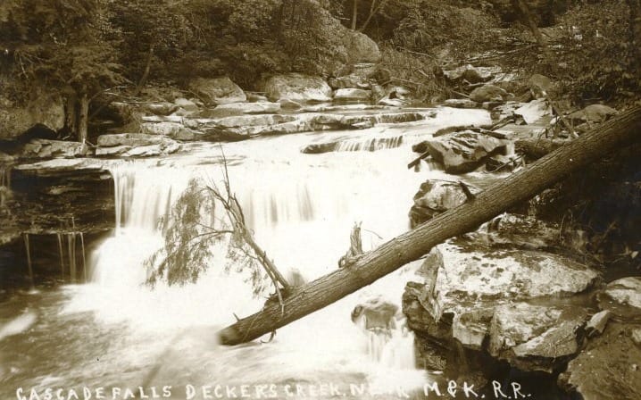
Falls of Deckers Creek along the M&K near Cascade circa 1920. Image West Virginia and Regional History
|
|
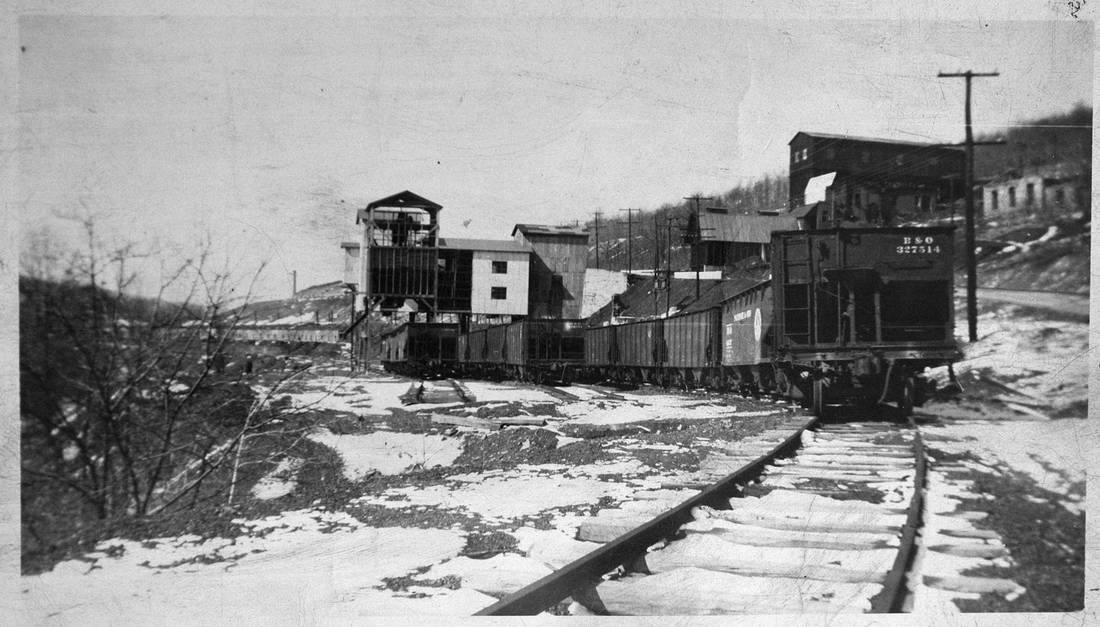
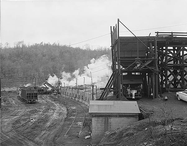
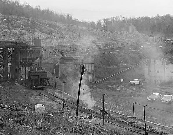
The Cascade mine tipple and sidings as they appeared during the late 1960s. An active location along the M&K it once was--a mine, coke ovens, and a power plant kept the hoppers moving. Image courtesy Jim Brown
|
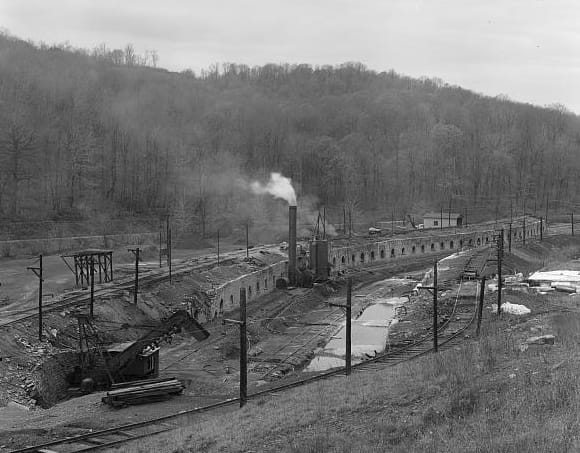
A 1973 view which reveals the long line of beehive ovens. The leafless trees of late autumn add to the barren environment of this operation. Visible on the opposite bank of Deckers Creek is the mainline. Image William Barrett /HAER/Library of Congress
|
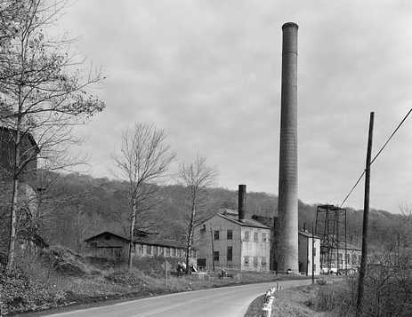
The massive smokestack of the power plant looms over WV State Route 7 at Cascade. This facility was located west of the coke ovens also adjacent to the rail spurs. Even when this photograph was taken in 1973, the complex looks forlorn encapsulating the fading industrial look of a passing era. What an interesting project the layout at Cascade would be to incorporate on a model railroad. Image William Barrett/HAER/Library of Congress
The Cascade coal and coke works were located on the north bank of Deckers Creek opposite the mainline. A track lead diverged from the main crossing the creek where multiple spurs diverged to serve the coke ovens, coal mine and power plant. Virtually no trace remains of this once busy operation at Cascade today.
A 1913 view of the mine and coke ovens at Cascade. This early image was taken from a bridge over Deckers Creek looking upstream. Image West Virginia Geological Surveys
Masontown
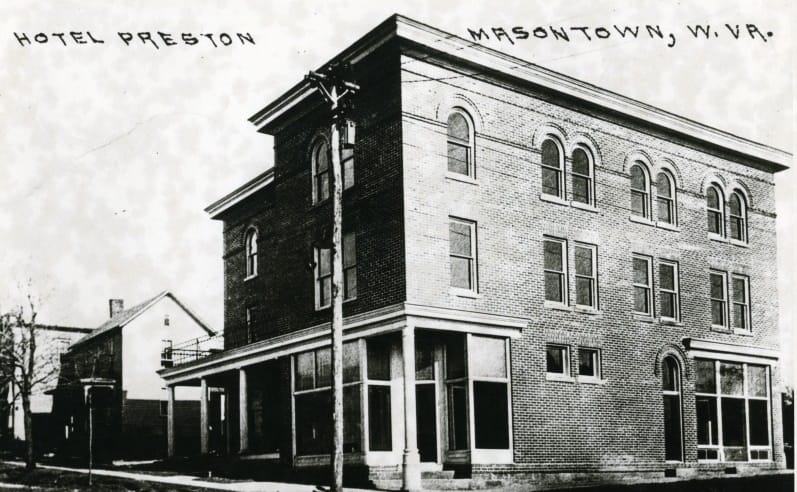
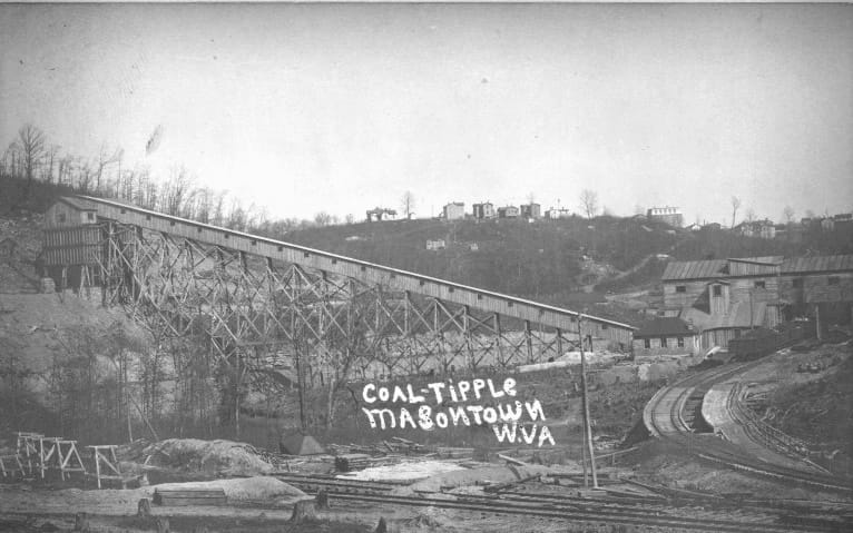
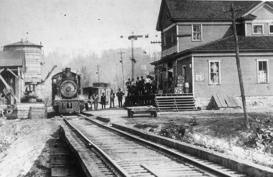
Masontown was the commercial center of the cluster of communities scattered along the railroad in this region that also included Cascade, Oak Park, and Bretz. In addition a business district, it included the Preston Hotel which slept any overnight travelers or officials on business at area industry. The railroad maintained a telegraph office here (call letters MS) and served online shippers as well. B&O listed the Preston County Coke Company to the west and the Sunny Hill Mine #6B as active in 1948.
|
Coal tipple at Masontown early 1900s. Not identified but could possibly be the Sunny Hill Mine #6B. Image West Virginia and Regional History
|
Masontown was another center of coke production along the M&K. A visually impressive image of the ovens on the contour of the curve. Image Jim Brown collection
|
Oak Park
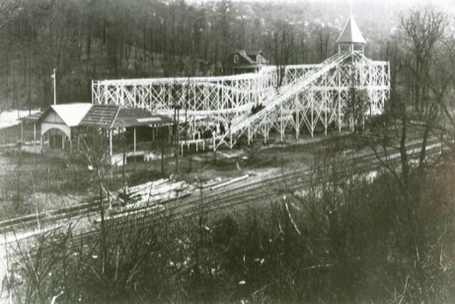
Located along the railroad between Masontown and Bretz, the Morgantown and Kingwood Railroad constructed an amusement park named Oak Park. Completed in August 1909, this recreational area was a draw for the surrounding region for two decades. The park included such amenities as a Ferris wheel, carousel, roller coasters, and paddle boats. In addition, it also accommodated overnight lodging, picnic areas, and walking paths. Baseball games were also played at the park comprised of teams from area towns and mining companies. It was quite the natural attraction sprinkled with a carnival atmosphere.
At its peak circa 1915, special passenger trains were operated from distant locations that included Connellsville and Pittsburgh, PA. Running south on the FM&P, the trains diverged onto the M&K at Morgantown for the short jaunt to Oak Park. Typically, these were weekend excursions during the summertime months. But as alluring as Oak Park was, the passage of time diminished its stature. The increase in automobiles which directly resulted in the decline of rail travel decreased the number of visitors with each passing year. In 1930, declined patronage combined with the onset of economic hardships with the Great Depression doomed Oak Park. It was closed the same year and later demolished. Only concrete pilings remain as a reminder of its existence.
The M&K located a 1440 foot passing siding at Oak Park. Since there was also another passing siding in proximity at Bretz, the primary purpose of the one here in its early years was to accommodate the trains stopping at Oak Park. This siding remained in place well into the B&O years and a water station was also in service here.
Bretz
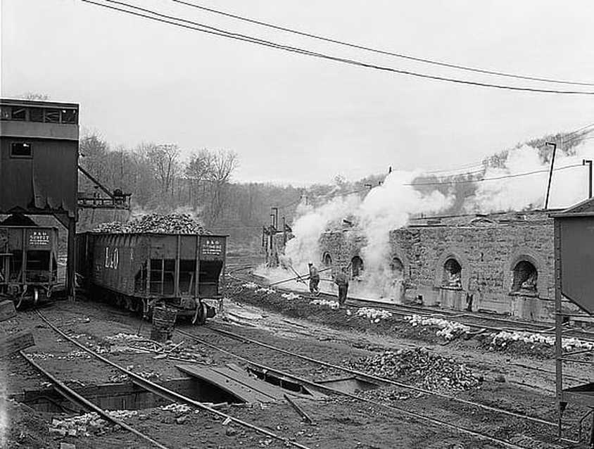
The town of Bretz was another community along the Morgantown and Kingwood Railroad greatly impacted by the influence of the Elkins Coal and Coke Company. Its Mine # 2 tapped the coal reserves here but it was the construction of beehive coke ovens that left the indelible stamp on the area. After Stephen B. Elkins purchased the mine from the West Virginia Coal Company, he set forth the construction of 400 beehive coke ovens that began full production in 1907. The production of coke at Bretz was destined for Baltimore and the massive Sparrow Point steel mill.
A close look at the Bretz coke ovens. The coke in the ovens is sprayed with water for cooling. At left, hopper cars with coal for the making of coke and another with the finished product. Image William Barrett/HAER
In 1919, the Bethlehem Steel Corporation acquired the Bretz coke ovens but the operation was shut down the following year. Coke making was transferred to a modern facility in Baltimore and the ovens at Bretz were used only in times of peak demand. Operation continued to be intermittent until 1953 when the Mercury Coal and Coke Company purchased the Bretz property. New equipment was installed as well as an upgrade to the ovens and the facility operated full time until it was shut down for the last time in 1981. The closing of the Bretz ovens was of historical significance---it was the last of the coke beehive ovens to cease operation in West Virginia and among the final ones to extinguish its flames in the United States. Due to this notable fact, the ovens were preserved and placed on the National Register of Historic Places.
An 1800 foot passing siding existed here to facilitate switching and to accommodate any meets. In addition to the coke ovens, B&O listed the Margaret Mine to the east of Bretz as still active in 1948.This operation was served by a spur from the M&K directly east of the Bretz wye installed by the railroad. Although there was industry in proximity that made use of the wye for locomotives to turn, its primary purpose was undoubtedly to turn the locomotives on the Oak Park trains for the return. Until the early 1970s, the coal and coke from Bretz moved east to M&K Junction at Rowlesburg. Once B&O abandoned the mid -section of the railroad between Reedsville and Kingwood, the movements hence ran west to Morgantown.
|
The region east of Bretz to between Guseman and Reedsville was the straightest section of track---approximately two miles-- on the 47.9 mile long railroad. Located along this stretch of railroad was a spur to Burke and the Elkins Coal and Coke Company Mine #7. In later years, this mine—or a newer one—became the Sunny Hill Mine #6A that was still operating as of 1948.
A view of Guseman from the railroad in 1908. Image West Virginia and Regional History
|
Reedsville
On the east end of the Preston plateau the M&K reached the small community of Reedsville. The region was first settled in 1827 by James Reed who would eventually own all of the tractable land for the future town named in his honor. During the formative years of the railroad the primary economic power, the Elkins Coal and Coke Company, was headquartered here. Reedsville was not large commercially in its importance to the M&K although it became a notable passenger stop along the route. The decade of the 1930s became significant with the Homestead Act creating Arthurdale and from the visits of two famous Americans of the era.
|
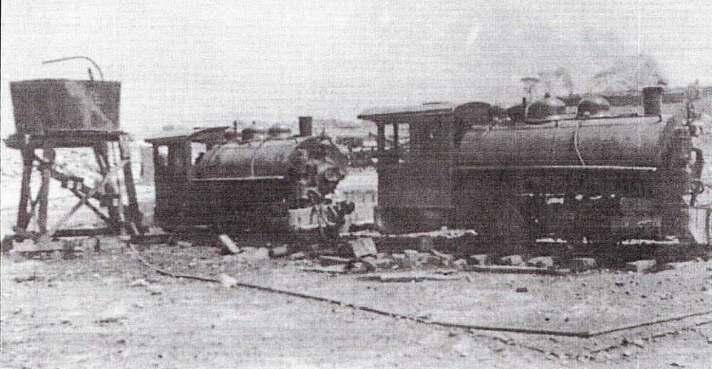
0-4-0 switchers on the M&K at Reedsville early 1900s. This power was likely used at the area mines on the M&K. Image Kingwood Public Library
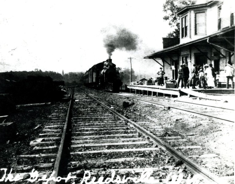
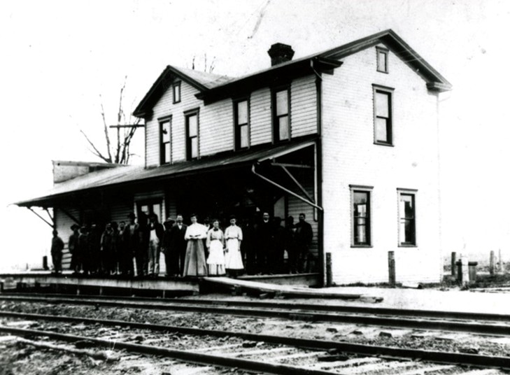
A train from Morgantown has arrived for its Reedsville stop. Train stations--large and small-- bustled with activity during the golden years. The folks on the platform--perhaps waiting on a loved one or boarding the train east themselves. Image West Virginia and Regional History
|
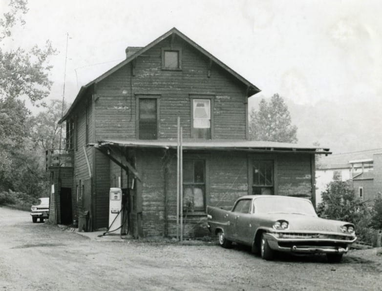
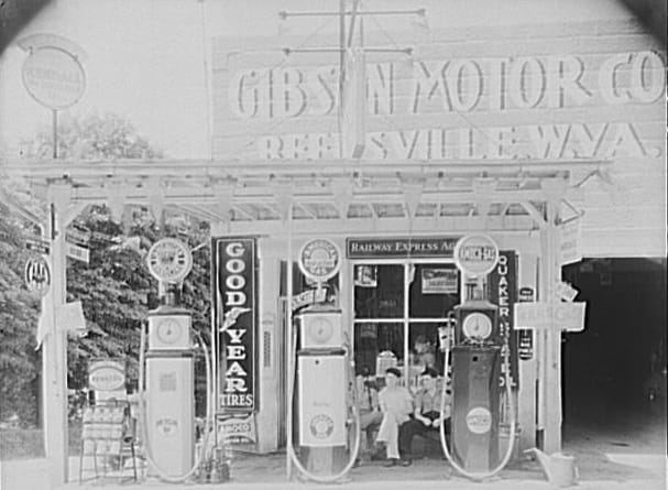
The Gibson Motor Company gas station at Reedsville during the 1920s. Plenty of detail here with the signage and charm of a long passed era. Note the Railway Express Agency sign above the window. Image West Virginia and Regional History.
Townspeople posed for the photographer in this circa 1920 image at the Reedsville depot. Note that the structure front has been modified from the previous photo. Image West Virginia and Regional History
|
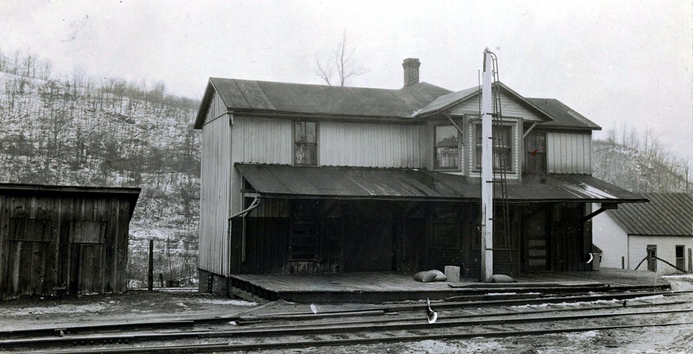
A company siding existed at Reedsville for storage and use as a team track as needed. In addition, a telegraph station was also located here with call letters RD and as of 1948, B&O listed the Belfort Corporation as an active shipper. Those familiar with the present day Deckers Creek Rail Trail know Reedsville as the eastern end of the trail that begins in Morgantown.
Arthurdale
During the 1930s, the Reedsville area received national attention from the creation of the adjacent Arthurdale homestead community, the first of one hundred to be constructed during the New Deal of the Roosevelt Administration. The premise was a development whereby employment, farming, and housing were self- contained within its confines. It became a project endeared to First Lady Eleanor Roosevelt commencing with the groundbreaking in 1934 and repeated thereafter on multiple occasions, the last occurring in 1960. As an interesting note, Eleanor Roosevelt on occasion would miss her train connection at Rowlesburg for the trip to Arthurdale. When this occurred, a local resident would take the First Lady by car---an act that would be impossible today. President Franklin D. Roosevelt also visited Arthurdale as well and rode by train on the M&K enhancing the lore of the era. All factors considered, there is little question that the railroad surely contributed to the construction of Arthurdale transporting materials and benefitting from an increased passenger base at Reedsville.
|
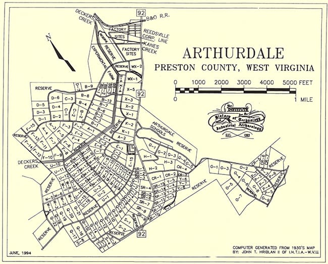
A town map of the Arthurdale development from the New Deal era of the 1930s. Also included is its relation to the town of Reedsville and the M&K (B&O at this date) Map courtesy Arthurdale Heritage.org
|
President Franklin D. Roosevelt and First Lady Eleanor attend an Arthurdale school graduation in 1938. A homestead project of the New Deal, Mrs. Roosevelt sustained an active interest in Arthurdale years after its development. Image West Virginia and Regional History.
|
Approximately half a mile east of Reedsville, a spur from the M&K led to the Arthurdale Mine. It ran in the general direction of Arthurdale and is certainly how it acquired the name. There is no indication of the mine at the location during the era of the Arthurdale homestead construction--it was perhaps opened afterward and before the onset of World War II. Topographical maps indicate its existence at least into the 1960s.
from Summit to River
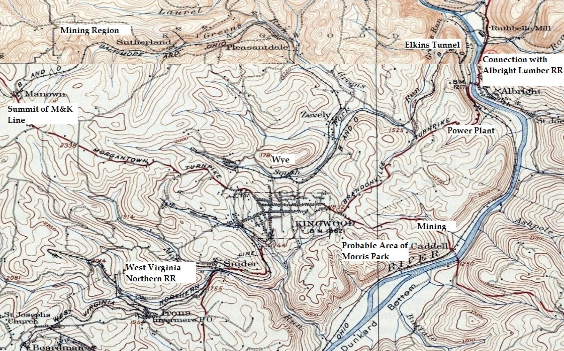
A 1931 topo map covering the region from Manown to Dunkard Bottom along the Cheat River near Caddell. This region was marked with grades and loops as the M&K underwent an extreme change in elevation between the mountains and river valley. Also included on this map is the well-known short line of Preston County, the West Virginia Northern.
The M&K east of Reedsville continuing through Kingwood to the Cheat River was without question shrouded in isolation and mystery. It is also the least documented and photographed section due in large part because of its difficulty to access. To the west, the communities were clustered in tighter proximity and WV State Route 7 essentially paralleled the railroad from Morgantown. There was no such thoroughfare as the railroad continued to ascend from Reedsville and through Morgan Mines before reaching its summit at Manown. Coal mining dominated this area as spurs from the main sprouted from the M&K main at communities such as Morgan Mines, Kanes Creek, Sutherland, and Pleasantdale.
The mountainous section of railroad between Reedsville and Kingwood was the domain of coal mining. Throughout the passing years, newer mines opened and older ones closed. Changes of ownership also kept existing mines upon although in most cases, renamed. B&O recorded in its 1948 annual the following shippers active in this remote territory:
Lyons: Reed Mine
Manown: L. H. & J.W. Borgman, Inc. and Stanley Coal Company. B&O also listed Manown as an active agency with telegraph call letters MA and a 1350 foot company siding.
Lyons: Reed Mine
Manown: L. H. & J.W. Borgman, Inc. and Stanley Coal Company. B&O also listed Manown as an active agency with telegraph call letters MA and a 1350 foot company siding.
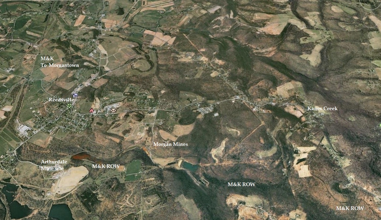
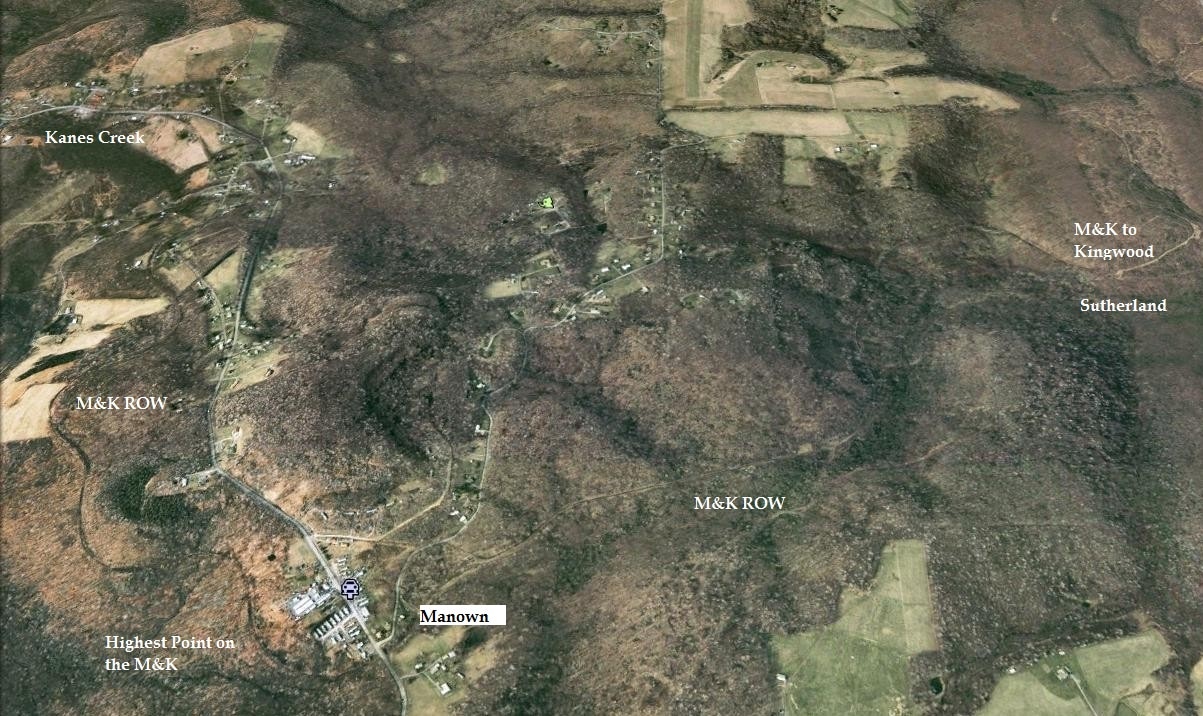
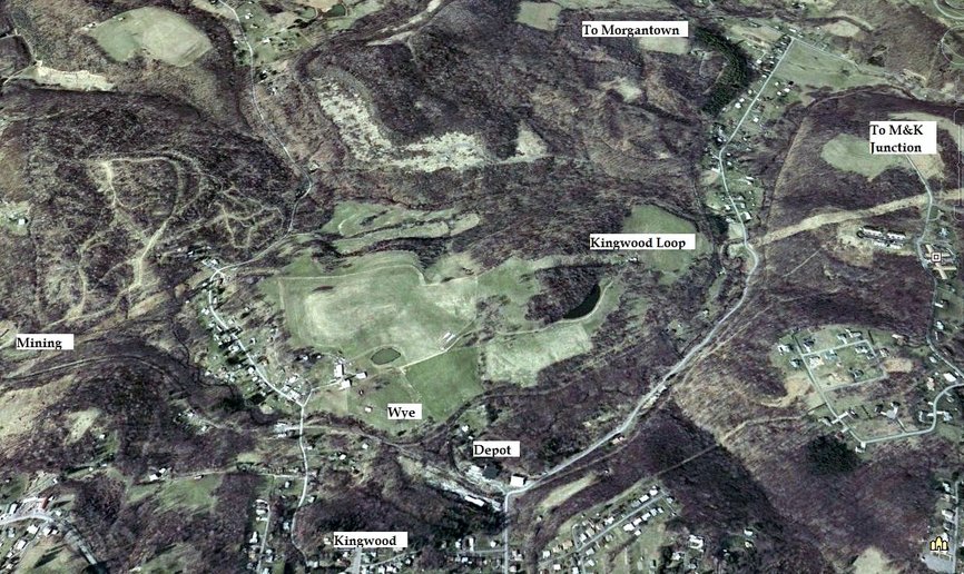
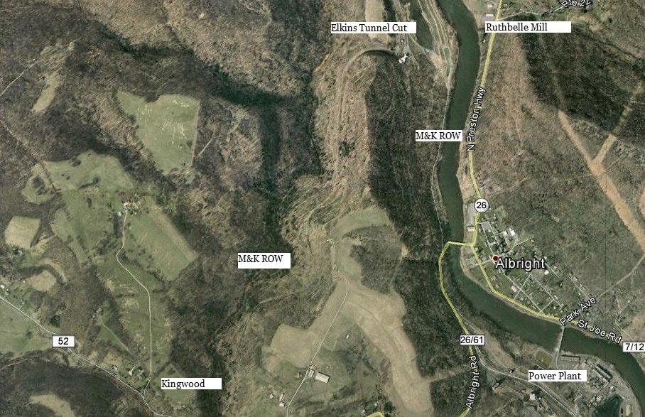
Two Google Earth snapshots of the rugged mountainous terrain traversed by the M&K east of Reedsville. The railroad twisted and turned as it negotiated the grades before reaching its summit at Manown. A region that once hosted coal mining along M&K is sparsely populated and largely inaccessible which explains the dearth of period photos. The best season to trace abandoned right of way is winter and these images are from December 2003 for better clarity.
If one traces the abandoned right of way in this region, the immediate realization is the crooked route the line used to reach the plateau region of Preston County from the Cheat River. There is nearly a 1000 foot difference in elevation between Manown and Albright. To achieve this change, the surveyors of this route utilized a series of loops to maintain a reasonable grade between these points. Moving eastward, the first loop is between Morgan Mines and Manown. Continuing downgrade into the Green Run drainage, the largest such loop on the route was at Kingwood. Using the South Fork Creek, the loop designed here practically doubled back on itself. The descent through Zevely into Kingwood was paralleled by the same loop east of town as the M&K returned to Green Run. Finally, on the approach to the Cheat River, the railroad used a third loop passing through Elkins Tunnel and entering the Cheat River Valley near Albright.
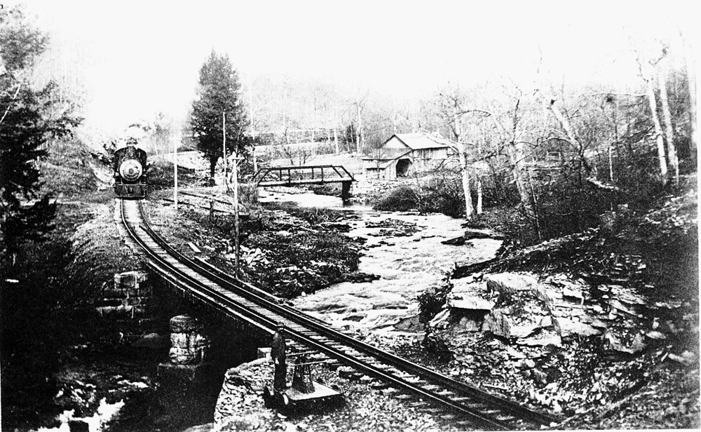
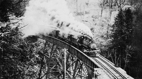
The M&K along Greens Run possibly in the Pleasantdale area circa 1915. This picturesque scene would make for a beautiful colorized postcard. Image Jim Brown collection.
Kingwood
The seat of Preston County, half of the namesake of a railroad traversing the region, ultimately resulted as an ironic choice. When Kingwood was selected with Morgantown to comprise the chartered name of the railroad in 1899, it was not envisioned that it would be seven years later in March 1906 that rails would finally touch the town. Once the railroad arrived, it discovered company if not competition in the form of the West Virginia Northern Railroad (WVNR). At first a narrow gauge timber hauling road, the WVNR converted to standard gauge by 1894 which also enabled it to transport the coal from the rich mining region. A short line operation, it was constructed between Kingwood and Tunnelton at which the latter it interchanged with the B&O mainline. Like the M&K, it was built in sections beginning in the 1880s, and after an ownership change, the final spike driven at Tunnelton after the turn of the century. Curiously, the two roads did not connect at Kingwood in spite of the considerable parallel histories. Any interchange that occurred between the two roads was transloaded by wagon.
|
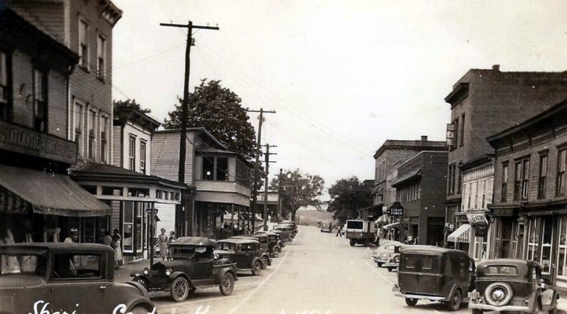
The business district of Kingwood circa 1930. Ironically, the town that shared the name of the railroad was not a large shipper. M&K rails were on the outskirts of town therefore not passing directly through it. Image West Virginia and Regional History
|
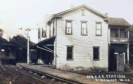
Kingwood depot as it appeared circa 1920. This structure was located inside the looping curve on the edge of town. The train in this scene is bound for Morgantown. Image Jim Brown collection
|
As the second railroad to arrive at Kingwood, the M&K could not secure a dominant position in the town. As a result, the line never penetrated the commercial district as it constructed on the northern fringe of town. It did build a depot and freight house in addition to locating a wye for turning locomotives and served area coal mines. But the WVNR had already laid claim to Kingwood by also constructing a depot, a yard, and most importantly, securing the bulk of the rail revenue. The WVNR could also provide passengers direct connection to the B&O mainline for furtherance east or west. In fact, the only real advantage the M&K had at Kingwood was the ability to offer a connection to points north and west via Morgantown.
|
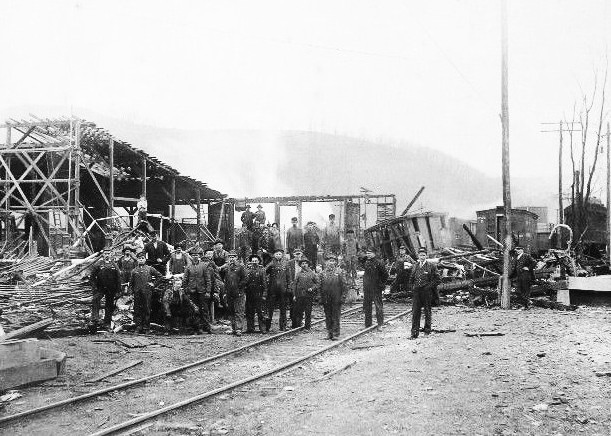
An image of a derailment and trackside structure damage circa 1915. Identified as Kingwood but may be in the Cheat River valley instead. Quite a number of men posed for the photographer as this unfortunate occurrence was recorded. Image Jim Brown collection
|
The West Virginia Northern Railroad early in its history. This short line operated between Kingwood and Tunnelton and remained in existence until the 1990s. Image West Virginia and Regional History.
|
Once B&O absorbed the M&K into its operations in 1920, a temporary advantage the M&K route acquired was an integration of passenger service within the B&O timetables. But this was not indefinite for as the years passed, the passenger base steadily eroded resulting in fewer trains. Finally, by the early 1950s, passenger service became a moot point as it ceased on the M&K altogether in 1953.
As of 1948, B&O listed Kingwood still as an agent with telegraph call letters KI as well as two shippers: the Preston Supply Company and the Riley #5 Mine. The mine was located at the end of the spur that extended from the wye.
|
Another 2003 Google Earth snapshot of the railroad right of way in the Kingwood area. The long loop at Kingwood is still clearly defined as is the changing elevation.
|
The terrain moving east of Kingwood as the railroad right of way heads downgrade on the approach to Cheat River. Another loop is visible here and the cut where Elkins Tunnel once stood is apparent.
|
|
Perhaps the greatest irony is the fact that the West Virginia Northern outlived the B&O at Kingwood itself. B&O continued to transport coal and coke from the west end of the M&K through Kingwood to M&K Junction until the late 1960s. It was during this time period, however, the coal mining diminished in the central section of the M&K—Reedsville to Kingwood—with closings and the remainder unprofitable to move. Added to this was a tortuous section of railroad to operate. B&O had effectively begun to operate the M&K as two remaining branch stubs prior to filing the Reedsville-Kingwood section for ICC abandonment in 1971. B&O was gone from Kingwood but the West Virginia Northern would remain for another two decades. Later generations associated Kingwood with the WVNR and M&K was hence relegated to the remaining track along the Cheat River and the legendary location on the B&O mainline.
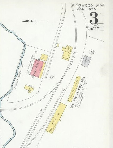
Kingwood 1933: In addition to the depot, shippers included Kingwood Wholesale Grocery and the West Side Planing Mill.
|
Albright Region
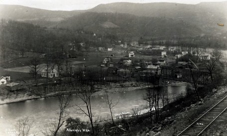
Eastbound travelers on the M&K and later B&O surely appreciated the vista upon exiting Elkins Tunnel and beginning the downgrade trek into Albright. Before their eyes, a sudden scenic transition enveloped as the railroad emerged into a valley and the rugged but beautiful Cheat River rushing below. No matter what the season---each with its own delight---it was surely a sight to behold. If the passenger was traveling through to Rowlesburg, the Cheat River would be his continued companion as he passed by viewing its rapids and pools. If Albright was the stop, the passenger prepared to cross this beautiful river upon arrival for the railroad did not pass directly through town for it was situated on the opposite bank of the river.
|
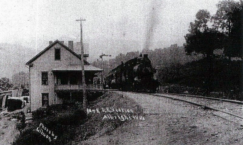
A westbound train is stopping at the Albright depot circa 1915. As the railroad did not pass directly through town, passengers at Albright had to cross the Cheat River to board the train. Image Kingwood Public Library
|
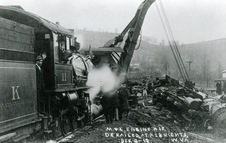
Derailments afflict railroads large and small. The M&K suffered one here at Albright in December 1912 as locomotive #10 left the rails. M&K #11 is assisting with the cleanup. Image West Virginia and Regional History
|
Albright was, in a sense, a transformation point on the M&K in two distinct regards. Economically, it was a transition point between timber and coal country. To the east, Preston County was prime timber country and to the west, the beginning of heavy industry related to coal. It was also a clear cut demarcation point that separated the M&K from its industrial plateau region and the sparse and rugged Alleghany Mountains sector.
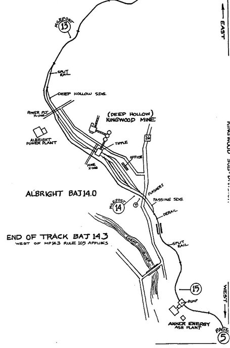
B&O, in its 1948 shippers report, listed the following data concerning Albright. Two mines in operation--the Depp Hollow Mine and also the Depp (river) Mine. Also, a telegraph station and agency with call letters AB was still active at that date. Once B&O abandoned the Reedsville-Kingwood section of the line during the early 1970s, Albright for all intents and purposes became the end of the line on the sub from M&K Junction. It would remain as the last active section of the M&K into the CSX era until it was eventually abandoned after the turn of the century.
|
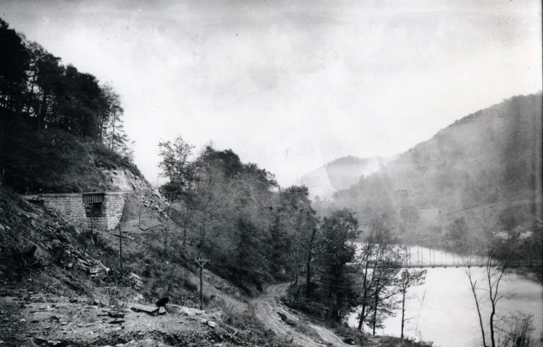
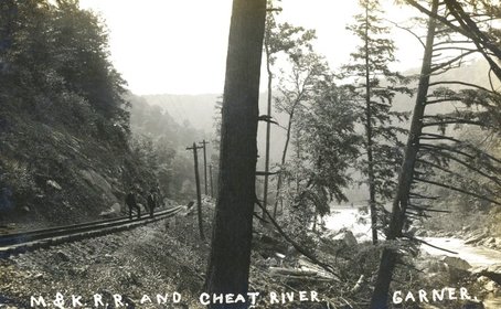
An early 1900s view of the M&K along the Cheat River possibly in the Caddell area. This photograph could have been taken during a train stop at Morris Park. Image West Virginia and Regional History
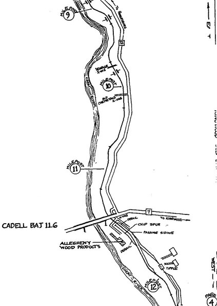
At left: A circa 1990 CSX map of the region near Caddell. During this time period, Allegheny Wood Products was an active shipper and a mine tipple is also indicated with track still intact. Map Bernie Beavers/CSXT
|
For nearly the entire history of the M&K as to include the B&O years, the Caddell area was a place name location in regards to revenue for the railroad. In fact, the community remained as a shipping point during the final years of the CSX era. Coal mining would develop here over the ensuing years and as of 1948, B&O listed the following operations as active: George-Kefover Coal Company and the Kefover Mine. In later years, a wood chip operation was installed here listed as Allegheny Wood Products (it may have had a previous name). A wood product business remains here today although without rail service.
Oak Park near Masontown is well known as a leisure stop along the M&K during the early years but another location sponsored by the railroad was along the Cheat River near Caddell near the Dunkard Bottom area. This stop, known as Morris Park, was all natural without any of the attractions of Oak Park. Instead, this was an all "nature" stop by scheduled trains for passengers to disembark and enjoy the scenic wonder of the Cheat River. A passing siding was located at Caddell that possibly accommodated these stops thereby permitting other trains unobstructed passage. For many years, this area has been utilized by the military reserves for training and is known as Camp Dawson.
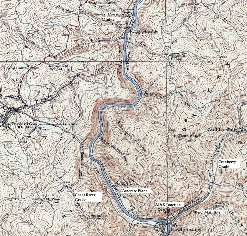
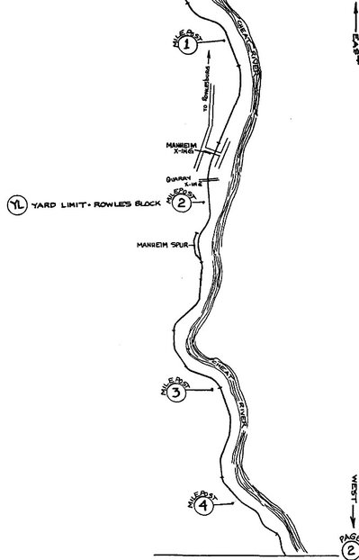
The easternmost section of the M&K from the vicinity of Preston to M&K Junction. The railroad paralleled the Cheat River through Preston as it crossed over to the east bank through Manheim to its connection with the B&O mainline. This map also includes Rowlesburg in addition to Cheat River and Cranberry Grades on the main.
|
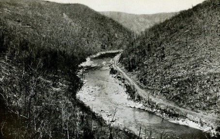
A circa 1913 winter view that looks west along the Cheat River between Preston and Manheim. This scene gives credence to the ruggedness that is the river valley in its natural state. The only imprint by man here is the M&K running along the south bank of the stream. Image West Virginia Geological Surveys
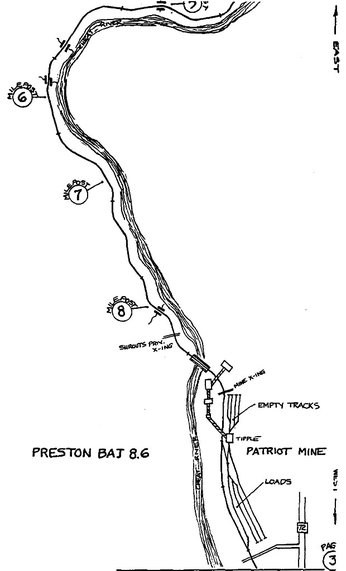
Coal mining at Preston and the area known as Trowbridge dates to the M&K years and continued into the B&O era. In its 1948 listing, B&O recorded the Glenwood Mine as a current shipper. The region continued to produce coal into the CSX era as the Patriot Mine. The railroad ran along the south bank of Cheat River from M&K junction until crossing the stream at Preston and henceforth continued along the north bank.
|
CSX era map of the railroad in the Preston area. The railroad crossed from the south bank to the north bank of the Cheat River here. Patriot Mine and track layout is notated as it was circa 1990. Map Bernie Beavers/CSXT
|
Manheim
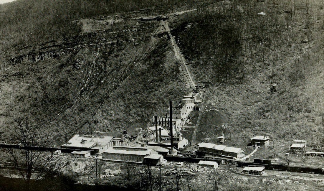
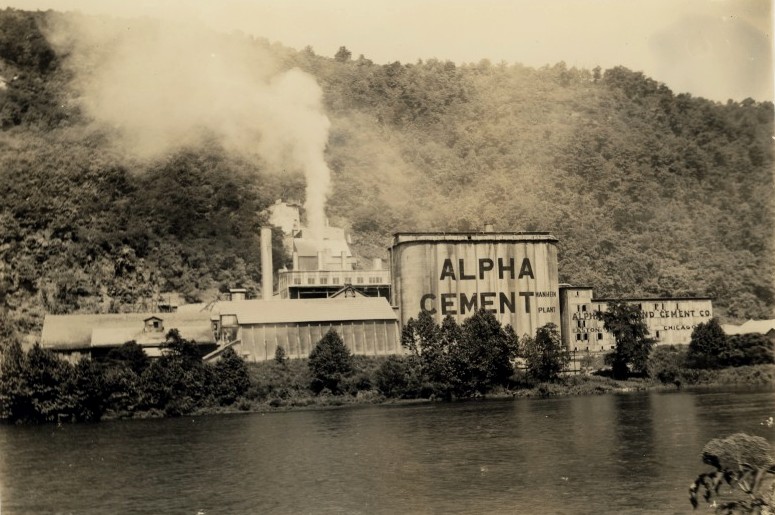
A remarkable image from 1913 of the Alpha Cement Plant during its early years. This view encapsulates the entire operation of the limestone quarry on the mountain as well as the cement manufacturing plant. The unknown photographer exhibited good timing--he also captured an M&K train switching cars at the facility. Image West Virginia Geological Surveys.
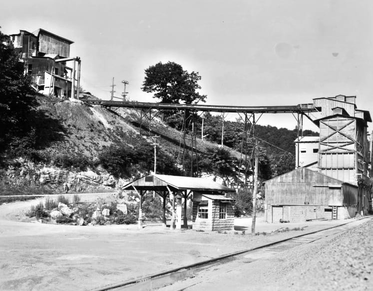
At the center of Manheim history is the limestone quarry and cement plant that was opened there by the early 1900s. Originally built as the Buckhorn Cement Company, it was purchased by the Alpha Portland Cement Company in 1909. For more than 50 years, the plant was the economic lifeblood at Manheim and generated uncounted carloads for both the M&K and B&O. The town was literally constructed by Alpha which included housing as well as the furnishing of utilities. The peak years of operation were the 1920s but over the course of time economic fluctuations and competition created the onset of decline. By the 1950s, the company as it was went out of business at Manheim. The former Alpha site has remained active as a limestone and crush facility known today as Cheat River Limestone. In 1948, B&O listed the Alpha Portland Cement plant as the single but albeit large shipper at Manheim. An agent and telegraph were still active with call letters MD and the location was also a water stop.
|
Circa 1990 CSX map of the railroad through Manheim. A spur is still indicated here and also indicated is the yard limit boundary from M&K Junction. Map Bernie Beavers/CSXT
|
The Alpha Cement as it appeared from across the Cheat River. This photo is dated circa 1930. Image West Virginia and Regional History
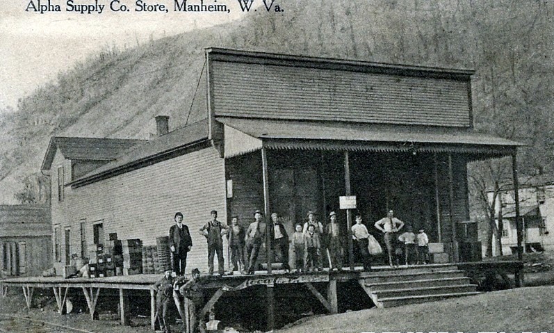
The Alpha Supply store at Manheim circa 1920. Apparently affiliated with the cement plant, this store turned a tidy business during the heyday of the concrete plant operation. Image West Virginia and Regional History
|
M&K Junction and Rowlesburg
The story of M&K Junction is but a chapter about the Morgantown and Kingwood Railroad condensed in a great volume about the Baltimore and Ohio Railroad. For this location, namesake of where the M&K at its easternmost point met the B&O, is enshrined as legend in the history of America’s first common carrier railroad. If one were to analogize the landscape at M&K Junction as the big stage, the B&O was surely the major star. A trunk line railroad connecting East and Midwest with a cast that featured premier passenger trains, fast freights, and coal trains all at the mercy of gravity. The drama was presented courtesy of the helper locomotives pushing on the rear of these trains ascending Cranberry and Cheat River Grades. In contrast, the M&K and later as the B&O M&K Branch, was a minor character in this epic play but in a supporting role contributed to the overall presentation. History has given it rave reviews.
|
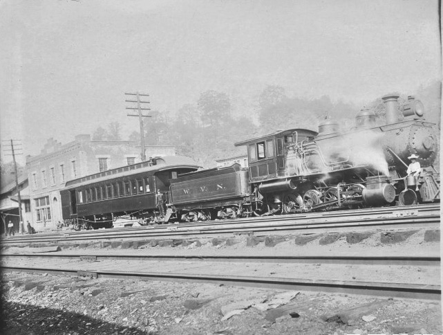
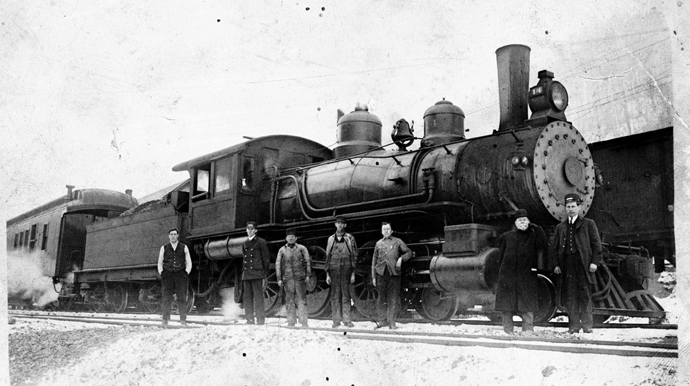
M&K 2-8-0 #14 at M&K Junction with the crew posing for posterity. Possibly the first passenger train to arrive on the completed railroad circa 1907. Jim Brown collection
|
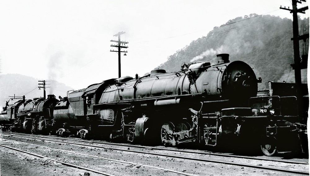
The everlasting perception of M&K Junction. In its full glory, a helper station with heavy steam power assisting trains over the Allegheny Mountains. Image Jim Brown collection
|
When the Morgantown and Kingwood Railroad arrived at the mouth of Saltlick Creek in 1907 at a location that would bear its initials, it fulfilled the nearly two decade old dream of George Sturgiss for a completed railroad. His railroad spanning Preston County spawned at the Monongahela River in Morgantown and now connected with the B&O mainline at Rowlesburg. In between lay a route rich in natural resources and laden with industry.
|
When the M&K operated in its entirety---as it did for most of its existence—the preponderance of its traffic volume moved east to M&K Junction. The coal and coke from Cascade, Bretz, and Masontown would be staged here for furtherance over the B&O main to the steel industry of Baltimore. The early and prime years of timber during the M&K formative years also found its way to M&K Junction not only from the M&K but the Rowlesburg & Southern Railroad. It was not until the late 1960s that traffic patterns were altered forever that decreased the volume at M&K Junction. Once the M&K route was abandoned between Reedsville and Kingwood, the line literally declined to a true branch serving only as far west as Albright. The remaining shippers west of Reedsville could only move carloads via Morgantown. During the later B&O years and extending into the CSX era, local power was assigned to M&K Junction to switch the remaining shippers as necessary. Coal traffic also originated on the branch from Albright, Caddell, and Preston running as needed. Eventually, this traffic ceased due to closures and CSX filed to abandon the last remaining segment---14.3 miles—in 2003. What was once a 47.9 mile bridge route between M&K Junction and Morgantown had perished completely from the map.
|
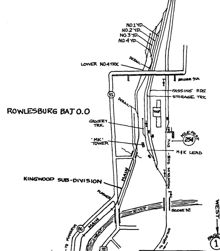
CSX map of the track configuration at M&K Junction circa 1990. Shown is the M&K connection within the yard and diverging route along the Cheat River. The CSX Mountain Sub and shop area is obviously diagramed as well, Map Bernie Beavers/CSXT
|
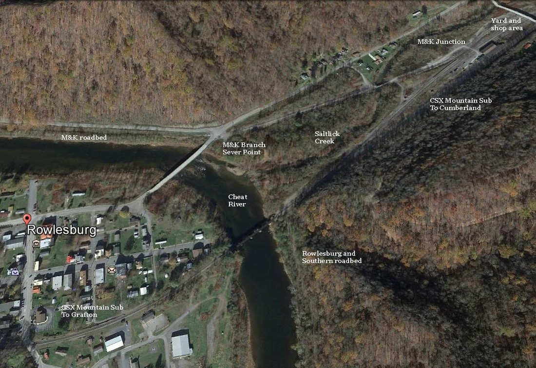
A Google Earth view of Rowlesburg and M&K Junction as it appears today. Although CSX is still active through here on the Mountain Sub, the tempo here is dramatically diminished from the past. The M&K Sub is gone, the M&K yard and operations are a shadow of yesteryear, and traffic on the Mountain Sub--once part of a through route to St. Louis--is reduced on what is now a secondary route.
In terms of the M&K, the otherwise prominent location of Rowlesburg in B&O annals was primarily that of a passenger stop. As the terminating eastern point for travelers, it served as a connecting point to the vast B&O network for points east and west. During the early M&K years during the peak era for passenger rail travel, six trains---three in each direction---were scheduled to coincide with connecting B&O trains. The reverse was also true for passengers arriving at Rowlesburg on B&O trains for connections to the M&K. After the B&O acquired the M&K, the timetables remained synchronized for the now comprehensive B&O passenger network. As time passed, however, the ridership declined, the number of trains decreased, and by 1953, the last passenger runs to and from the M&K had called at Rowlesburg.
|
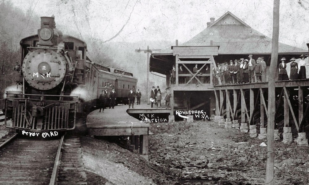
Very early photo of an M&K train at Rowlesburg. Depot is identified as M&K and alludes to a "prior yard". Modifications must have occurred at M&K Junction in the following years. Image Jim Brown collection
|
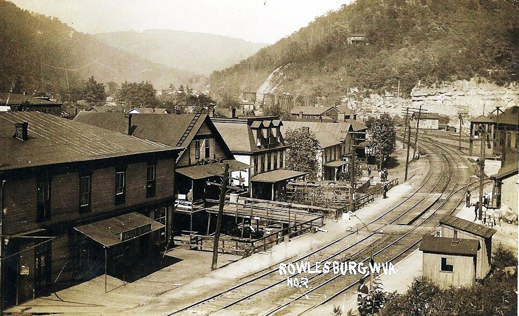
Eastbound view through Rowlesburg along the B&O mainline during its early 1900s heyday. The Rowlesburg depot is at right center and the Cheat River bridge is visible in the distance. At left center is the fabled Howard Hotel--the structure with three gabled widows. Image Jim Brown collection
|
Modeling Thoughts
If one were looking for a prototype to provide inspiration for the construction of a model railroad, the Morgantown and Kingwood Railroad would make an interesting choice. A railroad nearly fifty miles in length, it packs an industrial punch with variances in the terrain that convey diversity. In fact, it has the flavor of two distinct railroads packed into a relatively short length. The chosen era of which to model could be the M&K years (1903-1920), B&O (1920-1972), the Chessie System (1972-1985), or the final chapter CSX period (1986-2000). The M&K could be operated in its entirety—Morgantown to M&K Junction---or perhaps as two disconnected lines as it was from the 1970s onward. Of course, modeler’s license is an option to deviate from prototypical historical adherence in any phase of operation whether it is modest or great.
Motive power beginning with the steam era could incorporate any small to medium models. 4-4-0 Americans to 2-8-0 Consolidations were the norm but 2-8-2 Mikados would fit right in. Passenger trains could utilize both 4-6-0 Ten Wheelers or 4-6-2 Pacifics. Later era modeling could include an RDC (rail diesel car). The onset of the diesel era led to the dominant use of four axle EMDs (notably the GP9) but any subsequent models--- such as the GP30/GP35/GP38/GP40—would suffice for later years. Four axle models from Baldwin and Alco could also be substituted. Passenger trains did not survive to the diesel era in earnest but if one chose to do so, a GP7 or GP9 seemingly fits the characteristics of the M&K. Later years did witness the use of six axle power on the route between M&K Junction and Albright. EMD SD40-2s or even CSX era GE C40-8s and CW40-8s did operate here.
Motive power beginning with the steam era could incorporate any small to medium models. 4-4-0 Americans to 2-8-0 Consolidations were the norm but 2-8-2 Mikados would fit right in. Passenger trains could utilize both 4-6-0 Ten Wheelers or 4-6-2 Pacifics. Later era modeling could include an RDC (rail diesel car). The onset of the diesel era led to the dominant use of four axle EMDs (notably the GP9) but any subsequent models--- such as the GP30/GP35/GP38/GP40—would suffice for later years. Four axle models from Baldwin and Alco could also be substituted. Passenger trains did not survive to the diesel era in earnest but if one chose to do so, a GP7 or GP9 seemingly fits the characteristics of the M&K. Later years did witness the use of six axle power on the route between M&K Junction and Albright. EMD SD40-2s or even CSX era GE C40-8s and CW40-8s did operate here.
Industry along the railroad could feature timber from the early period with a dominant transition to coal occurring within a few years. Sand and limestone were also a hallmark along the M&K to be incorporated. Structures would include coal mines and the defining image of the M&K—the beehive coke ovens. The scale of manufacturing was small but could include a glass plant and other small operations for variety. A model railroad based on the M&K would possess scenic appeal in varying forms. The western end near Morgantown would feature smaller mountains defined by the Monongahela River and Deckers Creek basins. In the central section, a wide plateau region in Preston County where the railroad was straighter and relatively flat. To the east, higher mountains, deep valleys, and the Cheat River provide a marked contrast.
Highlights along the route to replicate in a scaled down version could include (1) M&K connection with the FM&P (2) Sabraton shops (3) Coon Creek Trestle (4) Hanging Rocks (5) coke ovens, mine, and power plant at Cascade (6) Oak Park (7) the serpentine curve at Kingwood as to include the depot (8) Elkins Tunnel (9) Alpha Concrete at Manheim and (10) M&K Junction. Obviously, there are other interesting features and scenes that could be added as well.
Highlights along the route to replicate in a scaled down version could include (1) M&K connection with the FM&P (2) Sabraton shops (3) Coon Creek Trestle (4) Hanging Rocks (5) coke ovens, mine, and power plant at Cascade (6) Oak Park (7) the serpentine curve at Kingwood as to include the depot (8) Elkins Tunnel (9) Alpha Concrete at Manheim and (10) M&K Junction. Obviously, there are other interesting features and scenes that could be added as well.
Credits
Arthurdale Heritage.org
Baltimore and Ohio Magazine
Jim Brown
Adam Burns
"B&O Power" by Lawrence Sagle published 1964
Bernie Beavers/CSXT
"History of Early Preston County"
Historic American Engineering Record/HAER
Kingwood Public Library
Library of Congress
Trail Link-Deckers Creek
US Department Of Interior
West Virginia Geological Surveys
West Virginia and Regional History Center
This page is dedicated to regional historian Jim Brown not only for his generous assistance with this effort but also for his work in documenting the histories of Monongalia and Preston Counties.
