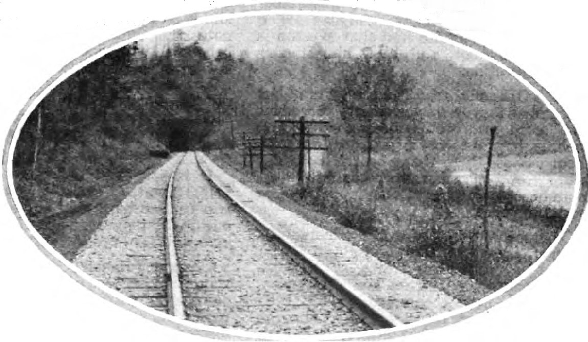
Parkersburg to Clarksburg-Waist of the B&O Main
part i
The late summer night temperature was in the mid-sixties for one who may have been standing at the Parkersburg High Yard during the early morning hours of August 31, 1985. As the city still slept, a headlight emerged in the distance from the east with the approach of a train as had happened many thousands of times before. The familiar sound of EMD locomotives gained in pitch as the train approached the beginning of the yard near the former location of SY Tower. As it moved into the yard, one would have seen a trio of GP40-2s with B&O #4136, B&O #4434, and C&O #4415 on the lead with a historical train of sorts. This was Train 89 that departed Grafton earlier and made its run over the Parkersburg Branch passing through the sleepy towns and tunnels that dotted the 104-mile run during the dead of night. One of uncounted trains to pass over these rails between Grafton and Parkersburg, it nonetheless was one of the most significant. After 128 years of existence, this was the last regularly scheduled timetable train to traverse the Parkersburg Branch.
Prologue

It has been almost three decades now since the towns and hollows between Parkersburg and Clarksburg last echoed with the sound of passing trains. A constant mainstay that was as common as mail delivery and passing automobile traffic, the railroad abruptly fell silent in 1985 ending a century and a quarter of what was perceived as everyday life. Local folks living along the route who were not necessarily privy to goings on of the railroad at some point were surely stricken with the curiosity of what happened to the trains and later bewildered as the track was being removed. All that was---the people, the trains, prosperity and depression, and sadly, the tragedies suffered by towns and railroad alike---combine to form this unique chapter of West Virginia and Baltimore and Ohio Railroad history coming to an end. The fine people of Wood, Ritchie, Doddridge, and Harrison Counties have done well to preserve this deep rooted heritage.
Known in B&O railroad circles simply as “The Branch”, the line from Grafton to Parkersburg indeed began life as one but ultimately became a link in a substantially larger corridor. As the Baltimore and Ohio Railroad expanded west through construction and acquisitions, the Parkersburg Branch became a section of a trunk mainline extending from Cumberland to St. Louis. Its route was strategic as a gateway railroad connecting the East Coast with the Midwest and for well over a century filled this role transporting freight and passengers to points close and afar. The territory the railroad traversed was archetypal West Virginia passing through small towns yet servicing with more complexity the cities of Parkersburg and Clarksburg. It possessed a charm that harkened to earlier times as much of the landscape along the route remained the same. As the railroad passed through northern West Virginia, it wound through the creek valleys touching the towns and crossing the drainage basins on numerous bridges. Unquestionably were the tunnels that defined the Parkersburg Branch. These were the signature element of the line and embellished its existence as a fascinating section of railroad. Mark Twain referred to it "as the longest subway in the world". In the later years of the Branch, these tunnels, unique from a rail enthusiast perspective, would prove to be more of a liability.
Many B&O name trains passed over these rails. Time (QD) freights such as Gateway 97, Cincinnati 97, and Cumberland 94 were staples for many years. Later years witnessed the advent of trailer on flat car trains (TOFC) such as the Manhattan and St. Louis Trailer Jets. During the glory years of passenger trains, the stately National Limited along with the Diplomat and the elegant but ill-fated Cincinnatian called the Branch home. Added to this are a multitudes of other named and unnamed trains, freight and passenger, local and long distance that ran the route. Presidents, the famous and near famous, but mainly people going about life in anonymity, rode its rails by the thousands for more than one hundred years. All were afforded superior service that was a hallmark of the B&O.
In 1985, all that was came to end. The Chessie System, itself on the eve of transition into CSX Transportation, dropped what was considered a bombshell at the time announcing that the railroad between Cumberland and Cincinnati would be downgraded from mainline status. Within three years, all operations had ceased, and track removal began between Parkersburg and Clarksburg eliminating the railroad altogether. This was a controversial abandonment both in railroad circles and the rail enthusiast community that continues as a topic of debate to this day. Whether perceived or real be it sentiment or shortsightedness, pros and cons simultaneously coexist on the impact of this decision in the context of past, present, and future.
The Baltimore and Ohio Railroad has a storied history and is well documented. Published volumes are bountiful but a glaring exception to this is relatively few works that cover the mainline west of Grafton onward to St. Louis. Smaller population densities and access to rural locales likely account for the primary reason of limited coverage and the Parkersburg Branch fits firmly in this category. Lack of operation was certainly not a factor. As a result, photographs and reference material are surprisingly sparse for a route that was prominent in the B&O network. In a related matter, the Parkersburg Branch is the source of my greatest historical rail regret. My work travels during the early 1980s took me to locations between Parkersburg and Clarksburg and I would see trains on the line on most of those forays. Regrettably, a camera did not accompany my other tools and the rationalization set in that I would take photos "someday". Needless to say, someday came and went in 1985 and the opportunities were lost forever.
I have opted to exclude Grafton from this piece although there will be references to it in the content. The reasons for this are twofold. First, the focus here is on the abandoned section of the Parkersburg Branch although Parkersburg and Clarksburg still retain active service. Second and most importantly, Grafton is a dynamic location in B&O history and still a player in modern day CSXT operations. Quite simply, it is a volume of and in itself that has been a subject covered by noted published authors such as Jay Potter and Bob Withers among numerous others. Any in depth effort on my part would pale in comparison although I do plan to include a general page about Grafton in the future.
CSXT operations will not be included in this page but for few exceptions. These will only be used as a basis for comparison and a discussion summary of the post 1985 abandonment. At first, I considered including CSXT images in this piece but decided that separate articles in the future would be more suited for that purpose.
Finally, readers who are familiar with the Parkersburg Branch and its history will undoubtedly recognize many of the images contained herein as they appear on other web pages or in the common domain. Through the generosity of these individuals and organizations, I have been graciously permitted to share them on this page for the creation of this piece. These contributors will be listed in the credits at the conclusion.
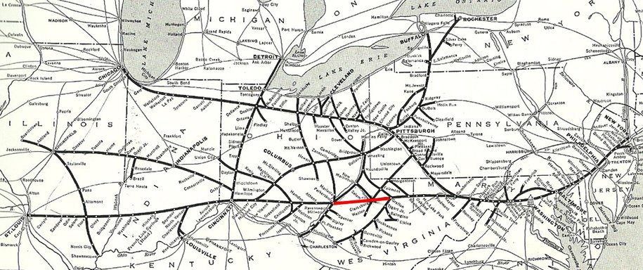
An often-published company map depicting the Baltimore and Ohio Railroad near its peak. The Parkersburg Branch is highlighted in red outlining its location within the St. Louis main line and its relationship to B&O network as a whole. In addition to most of the Parkersburg Branch, there are numerous other lines on this map that no longer exist.
Condensed History
The railroad that would become the Parkersburg Branch was among the earliest built lines in America. Predating the Civil War by a decade, it was chartered as the Northwestern Virginia Railroad (NVRR) in 1851 by the Virginia Legislature then subsequently backed by a group of Parkersburg businessmen as a precursor to future expansion and industrialization. Financing was provided by the City of Baltimore with a 1.5 million dollar loan and the B&O, with aspirations clearly on this route, contributed a like amount for the construction which commenced in 1852.
A number of political and business ventures were simultaneously in play with the construction of the Northwestern Virginia Railroad. B&O was completing its mainline from Cumberland to Wheeling precipitated by political pressure from both the City of Wheeling and the Commonwealth of Pennsylvania. The pressure from Wheeling was for the city to become the Ohio River terminus. Political forces in Pennsylvania coerced the route of its construction by not granting the railroad access to be constructed within its borders; hence, the tortuous route over the Alleghenies from Cumberland to Grafton and furtherance to Wheeling on a circuitous route.
A number of political and business ventures were simultaneously in play with the construction of the Northwestern Virginia Railroad. B&O was completing its mainline from Cumberland to Wheeling precipitated by political pressure from both the City of Wheeling and the Commonwealth of Pennsylvania. The pressure from Wheeling was for the city to become the Ohio River terminus. Political forces in Pennsylvania coerced the route of its construction by not granting the railroad access to be constructed within its borders; hence, the tortuous route over the Alleghenies from Cumberland to Grafton and furtherance to Wheeling on a circuitous route.
B&O fulfilled the building of the railroad to Wheeling not only from commitment but because it would be a profitable undertaking as well. But as early as the 1840s, it already had its eyes on westward expansion by building a more direct line connecting the markets of Cincinnati and St. Louis. Thus, it was no surprise that the B&O was firmly invested in the construction of the Northwestern Virginia Railroad for it was the initial step in the expansion to the Midwest. Once the railroad was completed between Grafton and Parkersburg in 1857, B&O set its sights on taking outright control. In 1856, the B&O and NVRR had signed an agreement whereas the former would complete the building of the road and operate the line for five years.
The Civil War wrought havoc on the B&O because of its strategic location as a borderline between the North and South. For the first time in history, the railroad became a military priority both in the transport of troops and material as well as a key target for the disruption of such. The campaigns in Western Virginia during the outset of the war are lesser known than in the East, but it was here that the railroad first demonstrated its impact on modernizing warfare. The Northwestern Virginia Railroad played a vital role in the transport of Union troops from Ohio to the East and the area was subject to raids by the Confederates attempting to thwart these movements. Similarly, Western Virginia was a tinderbox of divided loyalties and forces were in motion that eventually led to the creation of the pro union West Virginia in 1863. The B&O, through means direct and indirect, played a role in the formation of the new state born amidst the turmoil of war.
The Civil War wrought havoc on the B&O because of its strategic location as a borderline between the North and South. For the first time in history, the railroad became a military priority both in the transport of troops and material as well as a key target for the disruption of such. The campaigns in Western Virginia during the outset of the war are lesser known than in the East, but it was here that the railroad first demonstrated its impact on modernizing warfare. The Northwestern Virginia Railroad played a vital role in the transport of Union troops from Ohio to the East and the area was subject to raids by the Confederates attempting to thwart these movements. Similarly, Western Virginia was a tinderbox of divided loyalties and forces were in motion that eventually led to the creation of the pro union West Virginia in 1863. The B&O, through means direct and indirect, played a role in the formation of the new state born amidst the turmoil of war.
The NVRR, with meager capital assets, could not pay off its debts and the B&O purchased the line at foreclosure in 1865. The railroad had taken its first major step towards moving westward beyond the Ohio River. What would remain in name throughout its existence as the Parkersburg Branch would ultimately become a divisional segment of a mainline extending from Cumberland to St. Louis.
After the Civil War, railroad expansion accelerated and scores of communities located along the rails prospered with the onset of the Industrial Revolution. Most notably along the Parkersburg Branch were the cities of Parkersburg and Clarksburg. The former, located along the commercially viable Ohio River, became a gateway between East and Midwest by virtue of water and rail. Industry sprang up along the Branch and once the Ohio River Railroad was completed in 1888, Parkersburg was an axis of rail lines east, west, north and south. Further development in the Ohio Valley provided the Branch with additional freight revenue. Until 1871, traffic crossing the Ohio River into Ohio to points west and vice versa, had to be ferried fourteen miles to the connection at Marietta. The construction of the Ohio River bridge connecting Parkersburg and Belpre, OH in 1871 eliminated this tedious transfer of freight and passengers thereby drastically increasing the expediency of the railroad. Considered an engineering marvel, the Ohio River bridge was the longest of its type in the world for a number of years. Even today, it is an impressive structure to behold.
After the Civil War, railroad expansion accelerated and scores of communities located along the rails prospered with the onset of the Industrial Revolution. Most notably along the Parkersburg Branch were the cities of Parkersburg and Clarksburg. The former, located along the commercially viable Ohio River, became a gateway between East and Midwest by virtue of water and rail. Industry sprang up along the Branch and once the Ohio River Railroad was completed in 1888, Parkersburg was an axis of rail lines east, west, north and south. Further development in the Ohio Valley provided the Branch with additional freight revenue. Until 1871, traffic crossing the Ohio River into Ohio to points west and vice versa, had to be ferried fourteen miles to the connection at Marietta. The construction of the Ohio River bridge connecting Parkersburg and Belpre, OH in 1871 eliminated this tedious transfer of freight and passengers thereby drastically increasing the expediency of the railroad. Considered an engineering marvel, the Ohio River bridge was the longest of its type in the world for a number of years. Even today, it is an impressive structure to behold.
Clarksburg became a prominent location along the Branch through industrial development and as a junction for other rail lines connecting with the mainline. The manufacture of glass and industry related to coal were the hallmarks of the area. During the late 1800s, additional rail lines were built creating a hub for the region. Roads such as the West Virginia Short Line, the West Virginia & Pittsburg, and the Fairmont, Shinnston, and Clarksburg Railway radiated from the mainline connecting the area to other rail lines and industry. All of these smaller lines funneled traffic to and from the main and were eventually absorbed into the B&O system.
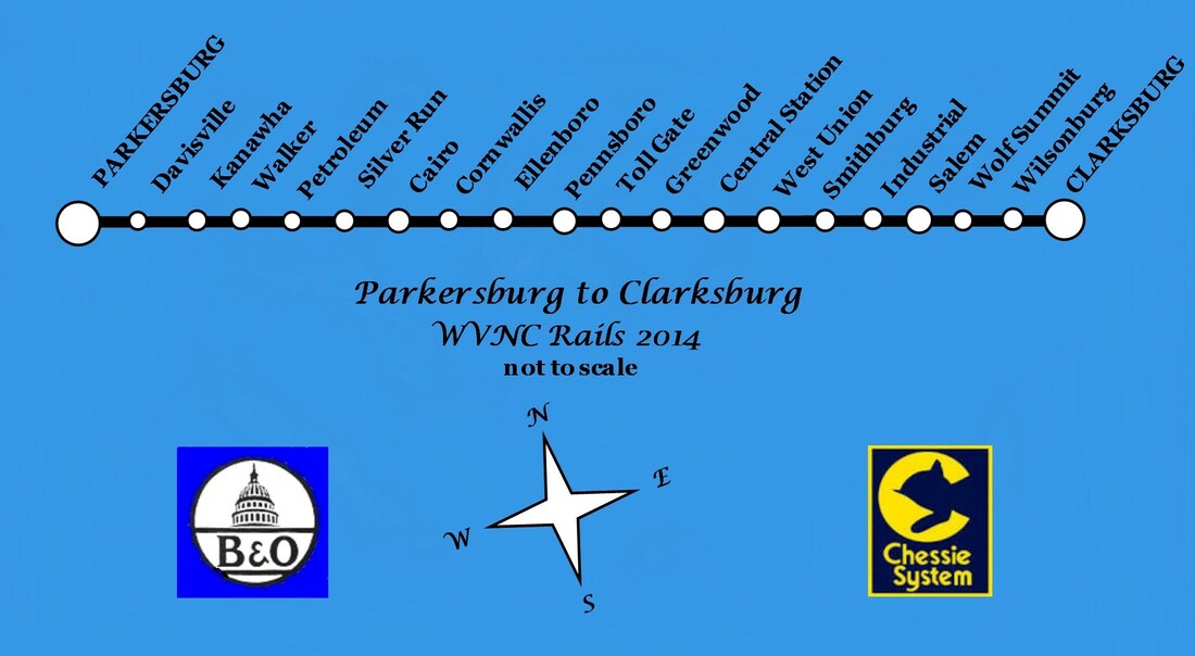
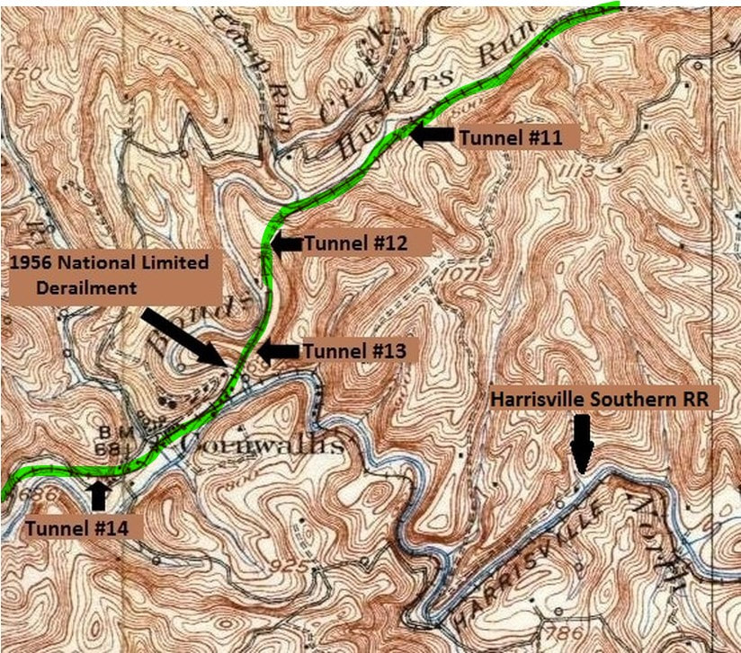
The Branch (mainline) between Parkersburg and Clarksburg was overwhelmingly rural with smaller towns and industry spread throughout its route. Communities such as Pennsboro, West Union, and Salem generated small amounts of rail traffic as did other locations along this sparsely populated section of railroad. Even smaller towns such as Cairo, Cornwallis, and Petroleum became junctions for tiny and relatively obscure short lines that all but vanished by the early 20th century. Most of the towns employed at bare minimum, a freight depot that furnished a means of shipping to the outside world. By the end of World War II, this on line freight scattered along the Branch had virtually disappeared. Never a major factor in the overall volume of freight that traveled the main, it was nevertheless a cited reason for the abandonment of the line in the 1980s.
The Branch (mainline) between Parkersburg and Clarksburg was overwhelmingly rural with smaller towns and industry spread throughout its route. Communities such as Pennsboro, West Union, and Salem generated small amounts of rail traffic as did other locations along this sparsely populated section of railroad. Even smaller towns such as Cairo, Cornwallis, and Petroleum became junctions for tiny and relatively obscure short lines that all but vanished by the early 20th century. Most of the towns employed at bare minimum, a freight depot that furnished a means of shipping to the outside world. By the end of World War II, this on line freight scattered along the Branch had virtually disappeared. Never a major factor in the overall volume of freight that traveled the main, it was nevertheless a cited reason for the abandonment of the line in the 1980s.
|
During the transition from the 1800s to 1900s, freight volumes continued to increase with the proliferation of mining and industry. This time period also coincided with the Gilded Era of the passenger train. The Parkersburg Branch, now fully integrated within the mainline connecting the East and Midwest, played host to numerous passenger trains of different classes. Long distance trains shared the route with secondary runs and added to this were the connecting trains from within the expanded B&O network and other roads. It was the golden age of rail travel and the Branch hummed with trains increasing the traffic total already laden with freight. The World War I years are often referred as the pinnacle in terms of traffic and existing number of route miles at a time when the rail network was at its peak. These halcyon years remained in earnest throughout the 1920s but by the time of the Great Depression, the rail scene was experiencing the beginnings of evanescence. Overall, certainly not unique to the Branch, however—this paragraph could be applicable to almost any railroad that existed at that time.
|
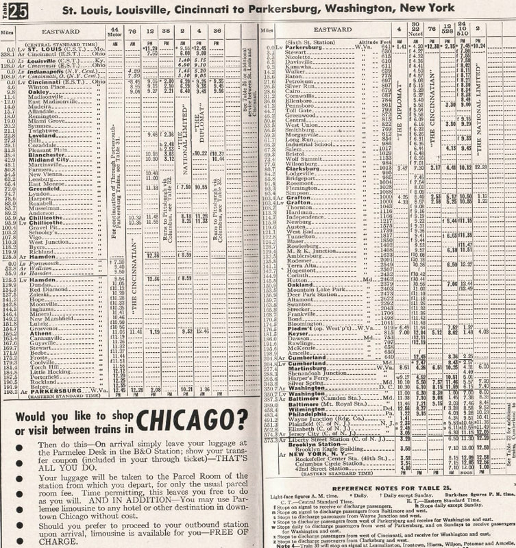
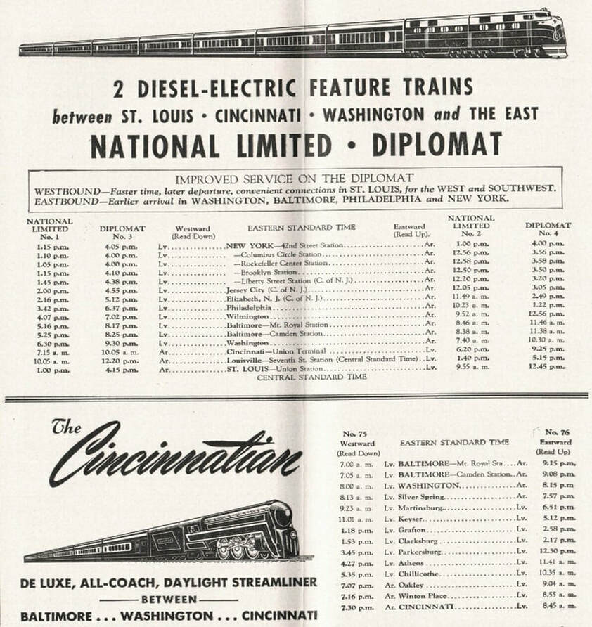
B&O published passenger timetable from 1948 listing the eastbound through trains that operated between New York and St. Louis
|
|
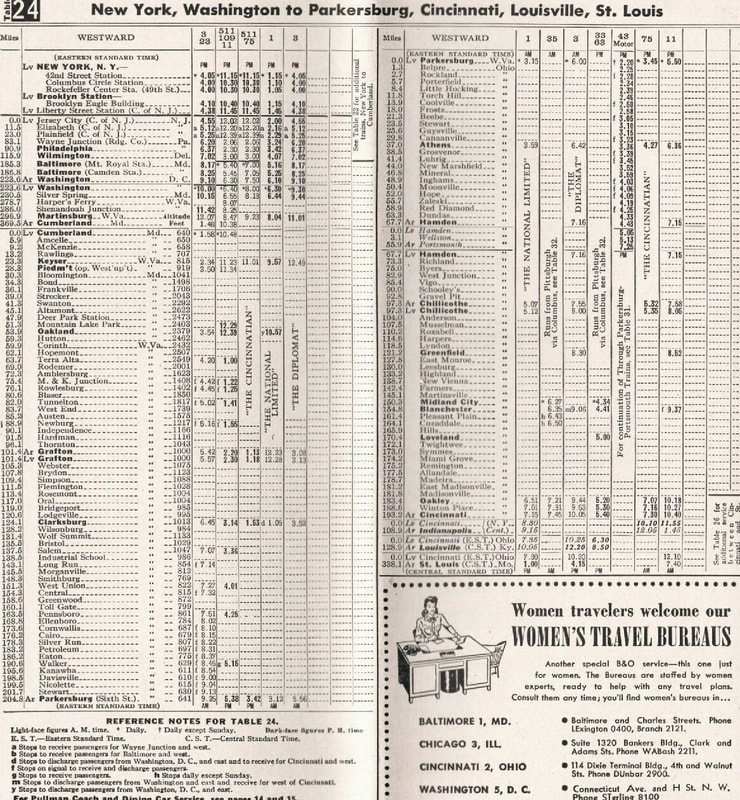
B&O published passenger timetable from 1948 listing the westbound through trains that operated between New York and St. Louis
|
Perhaps the first harbinger of the future was reflected in the decline of branch line passenger traffic that in turn, decreased numbers on mainline trains. The automobile was making inroads that affected short haul commuting and trucking did likewise to localized freight. Long distance freight and passenger trains were not directly affected as of yet due to a highway system that had not reached fruition. The major impact of the time though was reduced industrial output as a result of the Depression that did affect quantity. Industry took a hard hit in northern West Virginia during the 1930s as the demand for goods and raw material decreased. Firmly entrenched with manufacturing was the mining industry where lower demands and work strife were mitigating factors. Yet, in spite of the despair, this era is fondly recalled in rail history even if exaggeration rules the day. Better times lay ahead the B&O thought and along with other roads, an optimistic future of technological advances and the return of prosperity. By any measure, they were right and wrong. On the horizon was the 1940s and with it a global war that would change the landscape forever.
|
After Japan attacked Pearl Harbor on December 7, 1941, Admiral Yamamoto said “I fear all we have done is to awaken a sleeping giant”. The giant was American industrial might and the lifeblood of that was the rail system. How quickly this country mobilized for war production is an incredible chapter in history and the railroad was integral in this conversion. At the outset of the war, eight scheduled QD freights traversed the Parkersburg Branch in addition to at least a dozen timetable passenger runs. This did not take into account the extra trains already running the line and the numbers swelled proportionately with troop movements, oil trains, and second sections of scheduled runs directly related to the war effort. The impact of the wartime traffic taxed the Parkersburg Branch to capacity on a single track mainline with passing sidings and block operators. Maintenance on the line was time sensitive due to traffic volume. Very little was done during the war years except what was vitally necessary which usually translated into the aftermath of a derailment. One project B&O was able to complete during this volatile time was to daylight the flood prone Tunnel 23 at Kanawha, the westernmost of the tunnels on the Branch, in 1943.
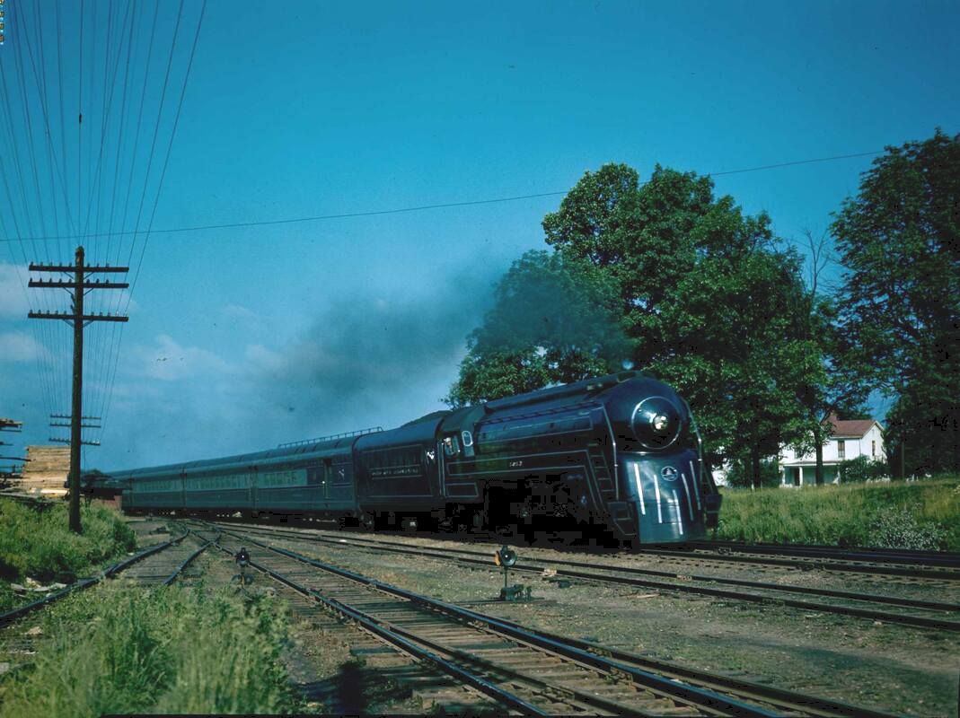
Once the war ended in 1945, traffic levels remained high as the country was beginning the process of demobilization. Passenger levels on the Branch ran high and trains such as the National Limited often ran in two sections to accommodate the volume. It was this immediate postwar traffic level that created a false optimism on the part of the B&O and other roads that this ridership would be sustained. Reflective of this spirit was the highly publicized launch of the Cincinnatian in 1947 in the hope that a daylight market Baltimore-Cincinnati train was viable. The trainset was a masterpiece in streamlined styling highlighted by four shrouded P7d class Pacifics as pooled power. At first excitement prevailed that the run would be a success---unfortunately, ridership peaked only at holiday periods. Ironically, due to the small capacity of the train, riders were turned away. The sad reality, however, that B&O soon realized it was a novelty and the swan song for the wartime levels. The public exodus from passenger rail had begun and the sparsely populated route of the Cincinnatian could not sustain a profitable operation. In 1950, the train was transferred to the Cincinnati-Detroit market where it fared much better. Symbolic of the changing times, decade of the 1950s would witness further contraction on a larger scale.
B&O, not unlike other major roads in the immediate postwar years, was optimistic about the future of passenger service. Ads such as these touting the National Limited, Diplomat, and the Cincinnatian reflected that hope. Sadly, it was short lived and by the 1950s, patronage had begun a rapid decline.
The 1950s signaled the true vanguard of change during the postwar era. B&O was transitioning from steam to diesel power and by 1958, this would be complete. Upgrades along the Parkersburg Branch had been forestalled during World War II and in 1951, Centralized Traffic Control (CTC) was finally implemented. Freight traffic remained steady on the line for most of the decade but rapid decline was occurring with passenger operations. Passenger trains on secondary and branch lines were systematically abolished due to loss of ridership to automobiles. Consequently, the transfer of patrons from these connecting lines to the Parkersburg Branch dwindled. The first long distance train casualty running the Branch was the Diplomat which ended service between Washington and Cincinnati in 1960. Over the road trucking in conjunction with highway development was making inroads and cutting into the freight business. By the end of the decade, B&O was suddenly in serious financial trouble and became the target of merger proposals by the 1960s.
As the New York Central Railroad and the C&O Railway became the primary roads interested in acquiring B&O, the road was in dire straits. B&O stock values plummeted, and it was in desperate need of equipment. The ICC approved the acquisition of the B&O by C&O in 1963 although both retained the individual corporate identities. The financially robust C&O quickly began resuscitating B&O with equipment and funding for critical system improvements. In early 1963, B&O embarked on a tunnel clearance project on the Parkersburg Branch enabling the movement of larger freight cars and trailer on flat car (TOFC) trains. This opened the market to Cincinnati and St. Louis that was previously restricted for these movements.1965 was the last year of the National Limited in its full glory but it continued on for a few years longer as a stripped shell of its former self before fading into oblivion. The passenger train had finally succumbed to automobiles and the airline industry.
The early 1970s were to prove an eventful period. Passenger rail was nearing its end as operated by the B&O and the majority other roads. The Metropolitan would be the last train to traverse the Branch under the B&O flag. On May 1, 1971, Amtrak took over the operation of the national network and for the first time since 1857, no passengers would ride the rails between Parkersburg and Clarksburg because the route was initially excluded. By late 1971 and through political pressure exerted by Representative Harley Staggers, a train returned to the route aptly named the West Virginian. By 1972, this train had morphed into the Potomac Turbo notable if but for its design by United Airlines. Distinctly different from standard passenger equipment, it proved a failure as it was ill equipped to operate over the mountain grades east of Grafton. Plagued with operational problems, standard road power often was used to assist it before finally assigned on a permanent basis. The train was a victim of low ridership west of Martinsburg, WV and was discontinued in 1973. Amtrak tested the waters again in 1976 with a Washington-Cincinnati train named the Shenandoah which would remain on the Branch into the early 1980s.
In 1971, there were still ten (10) scheduled through trains running the Parkersburg Branch. The total was evenly divided with five eastbound and five westbound entailing manifest and TOFC "jets". Ironically, this was the same number of scheduled timetable trains that existed at the outset of World War II. As was the pattern throughout its history, the total number of trains was higher with bulk (coal, grain, etc.) movements, second sections, and of course, local traffic. Unquestionably, the most significant development of the 1970s was the formation of the Chessie System in 1972 which combined the C&O, B&O, and Western Maryland into one operational entity. Each road retained its separate identity despite reorganizations and consolidations. Locomotives were painted in a colorful paint scheme sub lettered with the reporting mark of the owner. The Chessie System became the last face of the B&O not only on the Parkersburg Branch but elsewhere for the remainder of its operational existence.
Below is a list of daily scheduled manifest and TOFC trains that traversed the Parkersburg Branch on the B&O St. Louis main line as of September 1971:
Eastbound Westbound
Advance Manhattan (AMTN) Cincinnati Jet (CTNJ)
Manhattan (MHTN) St. Louisan (STLN)
Manhattan Trailer Jet (MHJT) Cincinnati 97 (CI97)
Cumberland 94 (CU94) Gateway 97 (GW97)
88 (St. Louis-Cumberland) St. Louis Trailer Jet (SLTJ)
Eastbound Westbound
Advance Manhattan (AMTN) Cincinnati Jet (CTNJ)
Manhattan (MHTN) St. Louisan (STLN)
Manhattan Trailer Jet (MHJT) Cincinnati 97 (CI97)
Cumberland 94 (CU94) Gateway 97 (GW97)
88 (St. Louis-Cumberland) St. Louis Trailer Jet (SLTJ)
The Parkersburg Branch began its final decade of existence with the formation of CSX Corporation in 1980. For the first half of the decade, CSX was a holding company for the Chessie System but the seed was planted for a mega merger with the Seaboard System. In 1986, the Chessie and Seaboard Systems were consolidated operationally into CSX Transportation. Meanwhile, during the early 1980s, six scheduled trains still ran the Branch in addition to extra movements. The Amtrak Shenandoah remained until 1981 when it was abolished because of low patronage. Thus ended passenger service forever on the Branch. Unforeseen was that freight traffic would soon follow suit.
The line received intensive maintenance work and operationally, perhaps in the best condition it had been for years. Then in 1985, an announcement was made that stunned many in railroad circles. A decision had made to downgrade the St. Louis mainline between Cumberland and Cincinnati with scheduled trains rerouted and extra movements simply annulled. The final scheduled train to traverse the Parkersburg Branch was on August 31 ---however, an excursion and extra movements continued thereafter for a brief period. Eventually, all traffic ceased and CSX filed a petition with the ICC to officially abandon the route between Parkersburg and Clarksburg. The State of West Virginia legally challenged the action to no avail and CSX removed the track between Walker and Wolf Summit in 1988.
Shortly after the track removal in 1989, a group stepped in to preserve the railroad right of way for use as a recreational trail. This was the seedling for what would become the North Bend Rail Trail. During the mid 1990s, the track east of Parkersburg to Walker was removed when the sole remaining shipper relocated elsewhere. The stub from Clarksburg west to Wilsonburg was removed in 1999 when a coal operator ceased operations. What remained of the former Parkersburg Branch between Grafton and Clarksburg was christened as the Bridgeport Subdivision in CSX operations.
The new millennium has witnessed the development of the North Bend Rail Trail as among the finest and it is a popular attraction. In addition to recreational opportunities it offers for hikers and bikers, it indirectly generates revenue for the small communities it traverses. Although it has been almost three decades since the last train passed, the North Bend Rails to Trails Foundation and the regional historical societies have to their credit kept the history of the Parkersburg Branch alive as well.
Operations
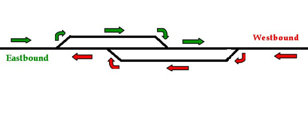
The Parkersburg Branch was predominately a single track main line populated with sidings at roughly 8-10 mile intervals during its peak. Except for a few standard passing sidings, the remaining were staggered or lapped sidings. These were constructed as two separate tracks on either side of the main with offsetting connecting points. In theory, these increased the operational length of the siding beyond the physical dimensions and were most effective with meets of opposing trains. Depending on the lengths of the meeting trains and if they could both utilize the sidings, a crafty dispatcher would route both trains through on a pass with neither requiring a stop.
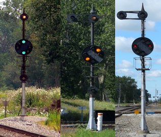
B&O operating practice was predominately eastbound trains governed as priority. There were deviations depending on whether trains were on schedule or if a high priority westbound train was involved such as Train #1, the National Limited. For many years lasting into the early 20th century, train orders controlled the movements of trains with specific instructions to the point which a stop or meet was required. Signals began to appear on the Parkersburg Branch during the 1920s in the form of color position lights and these were used in conjunction by the block operators positioned along the route at passing sidings. Depending on the signal indications, the operators would align the switches on the main or sidings according to instructions from a dispatcher.
B&O operating practice was predominately eastbound trains governed as priority. There were deviations depending on whether trains were on schedule or if a high priority westbound train was involved such as Train #1, the National Limited. For many years lasting into the early 20th century, train orders controlled the movements of trains with specific instructions to the point which a stop or meet was required. Signals began to appear on the Parkersburg Branch during the 1920s in the form of color position lights and these were used in conjunction by the block operators positioned along the route at passing sidings. Depending on the signal indications, the operators would align the switches on the main or sidings according to instructions from a dispatcher.
|
Distinctive B&O color position lights displaying proceed, approach, and stop indications. These signals populated the Parkersburg Branch as with other locations along B&O main lines.
These iconic signals have rapidly disappeared except for a few remaining locations as CSXT continues to standardize its system with a more modern---and generic--- type. Images Dan Robie 2009 and Matt Robie 2014 |
B&O had planned a conversion to CTC (Centralized Traffic Control) during the 1940s but World War II postponed its implementation for another decade. Although CTC would improve the efficiency of the railroad, it was a job killer. The block stations located between Parkersburg and Clarksburg were eliminated and replaced by a single dispatcher at Grafton by 1951. This dispatcher viewed a board with a track diagram for the Parkersburg Branch and from a desk controlled the passing siding switches and signals along the route remotely. CTC did not totally eliminate train orders---OB Tower at Parkersburg and MD Tower at Clarksburg remained as train order points into the Chessie System era.
The theory and practice of routing meeting trains through a lap siding. A coordinated move with train lengths, speed, and the proficiency of the block operator or dispatcher as factors.
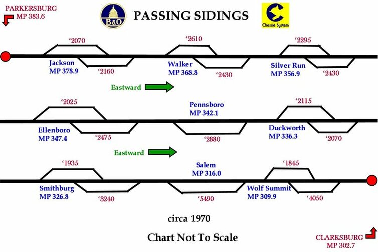
The chart below depicts the sidings as they are noted in the 1970 B&O timetable. During the intervening years between World War II and 1970, other sidings existed and were either eliminated or modified. A lapped siding at Cornwallis was taken out of service as were conventional sidings at Long Run and Petroleum. The lap siding at Salem was converted to a longer conventional single siding. Wilsonburg was also a lap siding but was converted to a storage siding in later years.
A block chart depicting the passing sidings located between Parkersburg and Clarksburg as they existed in 1970. Elimination and modification at a few locations since the 1940s had occurred. Sidings on the chart are exaggerated for clarity and the lengths are calculated capacity.
For a railroad spanning the breadth of northern West Virginia, the Parkersburg Branch is not generally associated with the movement of coal trains although this type of traffic did traverse the route. Instead, it was the road of priority manifest trains moving east and west and of course, passenger trains great and small. This remained as the traffic pattern until the 1950s when the passenger trains began disappearing from the timetables. From the mid 1960s to the closing of the line in 1985, manifest prevailed but the association changed to that of the route of the trailer (TOFC) trains.
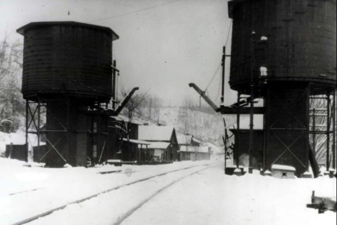
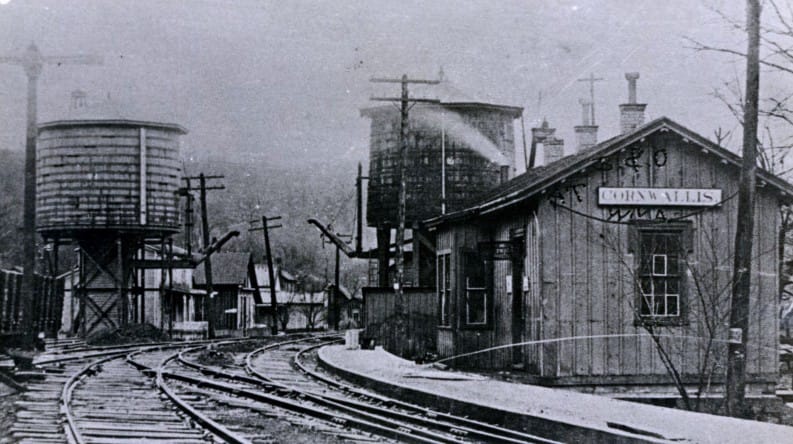
Throughout the history of the Parkersburg Branch, the motive power ran the gamut as the steam locomotive progressed in development. Of note was that the largest and most powerful of steam locomotives were not necessarily assigned to the line. Power such as 4-8-2 Mountains and articulated models such as EM1 2-8-8-4s were not regular Branch visitors. The mainstays on the line were the 2-8-0 Consolidations and 2-8-2 Mikados (MacArthurs during World War II) in freight service with various classes of 4-6-2 Pacifics pulling the passenger varnish. Complete steam servicing facilities were located at Parkersburg and Clarksburg with water stops at Petroleum, Cornwallis, Central Station, and Rock Run near Smithburg in between. The stop at Central Station was gone by the World War II era.
Throughout the history of the Parkersburg Branch, the motive power ran the gamut as the steam locomotive progressed in development. Of note was that the largest and most powerful of steam locomotives were not necessarily assigned to the line. Power such as 4-8-2 Mountains and articulated models such as EM1 2-8-8-4s were not regular Branch visitors. The mainstays on the line were the 2-8-0 Consolidations and 2-8-2 Mikados (MacArthurs during World War II) in freight service with various classes of 4-6-2 Pacifics pulling the passenger varnish. Complete steam servicing facilities were located at Parkersburg and Clarksburg with water stops at Petroleum, Cornwallis, Central Station, and Rock Run near Smithburg in between. The stop at Central Station was gone by the World War II era.
Train #76, The Cincinnatian, moves east through Belpre, OH in June 1947 soon to cross the Ohio River and enter Parkersburg. This train was introduced in January 1947 with great fanfare but within three years, it was discontinued between Baltimore and Cincinnati due to low ridership. Although short lived, a beloved train if for no other reason than appearance sake. A beautiful trainset powered by four magnificently streamlined P7d Pacifics in gleaming Royal blue. Image Richard J. Cook/Allen County Museum
The early diesel era was exemplified by EMD E units in passenger service and F units for freight during the transition from steam. By the early 1950s, EMD four axle (GP series) hood units entered the scene and became the backbone of the B&O fleet lasting through the Chessie System era into the formation of CSX. Six-axle EMD power such as the SD35, SD40, and SD50 traversed the Branch but these units were typically used as helpers on the West End grades east of Grafton. The Branch also hosted models by Alco and Baldwin although in most instances, these were smaller locomotives used in yard and local branch line service. Grades along the Parkersburg Branch were a lesser issue in the diesel era since multiple units could be lashed together to match the tonnage.
The Parkersburg Branch was the artery for the B&O Monongah Division. Connecting with the mainline were numerous secondary and branch lines that funneled coal from mines scattered across northern and central West Virginia. Though the vast volume of this tonnage moved east via Grafton and the West End, a considerable amount also moved westward over the Branch. This was also an area deeply associated with the oil and gas industry in addition to glass manufacturing. Manifest traffic of various sorts was prevalent as well especially in the era predating the Interstate Highway system. As one would expect, Parkersburg and Clarksburg were the hubs for this concentration of industry with sporadic shippers scattered along the Branch. Longer distance trains contained blocks of cars for Parkersburg and Clarksburg with locals distributing cars to and from these points.
The Parkersburg Branch was the artery for the B&O Monongah Division. Connecting with the mainline were numerous secondary and branch lines that funneled coal from mines scattered across northern and central West Virginia. Though the vast volume of this tonnage moved east via Grafton and the West End, a considerable amount also moved westward over the Branch. This was also an area deeply associated with the oil and gas industry in addition to glass manufacturing. Manifest traffic of various sorts was prevalent as well especially in the era predating the Interstate Highway system. As one would expect, Parkersburg and Clarksburg were the hubs for this concentration of industry with sporadic shippers scattered along the Branch. Longer distance trains contained blocks of cars for Parkersburg and Clarksburg with locals distributing cars to and from these points.
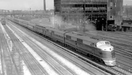
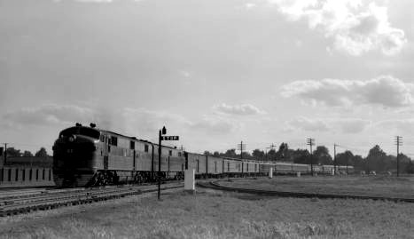
The two premier passenger trains to traverse the Parkersburg Branch were the National Limited and the Diplomat. Throughout most of their careers, these trains--both eastbound and westbound--passed between Parkersburg and Clarksburg during the night which explains the dearth of photos on the Monongah Division. Pictured here in different locales are, left, the eastbound National Limited Train #2 departing St. Louis in 1940. At right is Train #4, the Diplomat, passing through Vincennes, IN in 1950. Both images Otto Perry-Denver Western Library.
Grades
The Branch grades do not compare with ones east
of Grafton but it was hardly a flat piece of railroad between Parkersburg and
Clarksburg. Grades at a few locations
did exceed 1% which is not stiff but certainly a respectable climb and explains
the practice of doubleheading power during the steam era to maintain trains at
speed. The grades still faced diesels but additional units could easily be
added to accommodate the tonnage. Eastbound trains overwhelmingly faced more of
the ascending grades and conversely, westbounds drifted down more descending
ones.
The toughest stretch of railroad traversed by both was the region between Cairo and Walker. It was a climb to Silver Run from either direction just as it was a climb from Petroleum in either direction. The longest continuous climb was for eastbounds from West Union to Wolf Summit with the ascent between Long Run and Industrial the steepest section. Eastbounds also faced noteworthy ascents from Walker to Eaton and Cornwallis to Ellenboro. The toughest span for westbounds was Cairo to Tunnel #21 at Eaton and Wilsonburg to Wolf Summit. Extremes in elevation above sea level ranged from Parkersburg at 614 feet to Wolf Summit at 1119 feet----505 feet of difference.
The toughest stretch of railroad traversed by both was the region between Cairo and Walker. It was a climb to Silver Run from either direction just as it was a climb from Petroleum in either direction. The longest continuous climb was for eastbounds from West Union to Wolf Summit with the ascent between Long Run and Industrial the steepest section. Eastbounds also faced noteworthy ascents from Walker to Eaton and Cornwallis to Ellenboro. The toughest span for westbounds was Cairo to Tunnel #21 at Eaton and Wilsonburg to Wolf Summit. Extremes in elevation above sea level ranged from Parkersburg at 614 feet to Wolf Summit at 1119 feet----505 feet of difference.
Connecting Lines
As the B&O corridor through the Monongah Division, the Parkersburg Branch was the funnel connecting points east and west as a sector of the St. Louis main line. During the peak years of operation, a spider web of secondary and branch lines radiated from the mainline at various points along the 80 mile stretch between Parkersburg and Clarksburg. Beginning at Parkersburg, a connection to the Ohio River Line which spanned the valley between Kenova and Wheeling. Also, a B&O branch--originally the Little Kanawha Railroad-- extended to Elizabeth paralleling the Little Kanawha River into Wirt County. This line was eventually abandoned excepting for a small remnant at Parkersburg that became the short line Little Kanawha River Railroad. Although across the river in Ohio, Belpre was the western boundary of the Monongah Division and a connection to the former Marietta and Cincinnati Railroad.
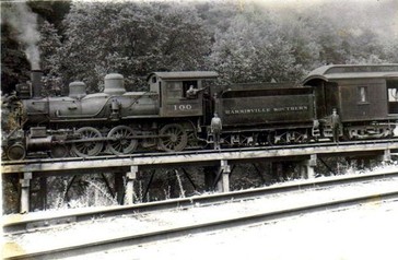
Small short lines that connected with the Parkersburg Branch include the Laurel Fork & Sand Hill, a small railroad constructed from the B&O at Petroleum to the town of Volcano during the great oil boom. Continuing east, the Cairo and Kanawha Railroad extended from its connection with the B&O at Cairo to McFarlen situated along the South Fork Hughes River. The Harrisville Southern interchanged with the B&O at Cornwallis and terminated at the Ritchie County seat of Harrisville. A narrow gauge line (P&H) once traversed the countryside from Pennsboro to Harrisville and later extended beyond. These small lines faced extinction by the early 20th century and were relegated to memory.
Clarksburg was a quintessential B&O town with secondary lines intersecting with the Parkersburg Branch. The Short Line connected with the main at the west side of town and extended to New Martinsville where it connected to the Ohio River Line. Another B&O line---the MR -- ran from Clarksburg through Haywood and continuing to Fairmont. Extending south from town was a former West Virginia & Pittsburgh route to Weston that was ultimately acquired by the B&O.
Parkersburg
This 1904 topo map provides a look at the railroad layout in the Parkersburg vicinity at its peak. The Parkersburg Branch (green) enters town from the east along the Little Kanawha River and crosses the Ohio as a continuation of the mainline to Cincinnati. The Ohio River Railroad (B&O-red) parallels its namesake as a route between Wheeling and Kenova. Both the High and Low Yards are active and the Little Kanawha Railroad (B&O-purple) occupies the south bank of the stream for which it is named as a route to Elizabeth. Also across the river in Ohio, the B&O line to Marietta (yellow) diverges from the main at Belpre.
Even as B&O was constructing its route from Grafton to Wheeling, the company had its eyes on Parkersburg as an eventual launching point for westward expansion. In fact, as early as 1842, a rail line to Parkersburg was considered the long term primary objective instead of Wheeling. The reasons for this were twofold; first, a railroad to Parkersburg offered a more direct route across Ohio to Cincinnati and eventually, St. Louis. Second, in an era before locks and dams were built on the Ohio River, Parkersburg offered better stability in water levels because it was farther downstream. This was a critical factor in the years before a bridge was built as freight and passengers were transferred by water from the West Virginia side to the Marietta and Cincinnati Railroad connection at Marietta, OH. Once a bridge across the river from Parkersburg to Belpre was completed in 1871, the river became a moot factor. An engineering masterpiece upon its completion, it was the longest bridge of its type in the world for several years. The stone used for its piers was quarried in the West Union area.
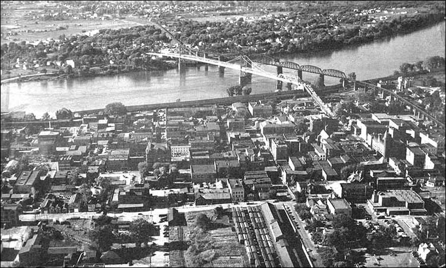
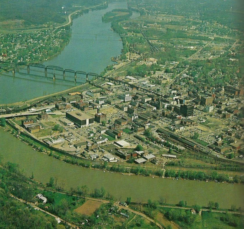
A look at the Parkersburg riverfront frozen in time as it was 1952. The aerial image places into context the expanse of the B&O Ohio River bridge. Adjacent to it is the 5th Street suspension bridge and the flood wall can be seen below both. Note the boxcars at the terminal in the foreground. Readers familiar with Parkersburg can spot what still exists in this image as well as what vanished from the wrecking ball. Image courtesy Parkersburg WV-A Vintage portrait.
The Staunton-Parkersburg Turnpike had been completed a short two decades once the rails of the Northwestern Virginia Railroad reached Parkersburg in 1857. As a superior means of travel, the railroad was the choice for commercial movements of freight and passengers west of Grafton. During the Civil War years and through Reconstruction, the Parkersburg Branch and connection continuing into Ohio was a rail monopoly within the area until the construction of the Ohio River Railroad in the 1880s. This line paralleled the Ohio River between Wheeling and Kenova providing north and south rail service as it intersected the east west route at Parkersburg. Commerce flourished along the ORR in the river valley and this line was ultimately absorbed into the B&O in 1912 creating a prosperous rail region exclusive to the road. The 1890s witnessed the construction of the Little Kanawha Railroad which paralleled the namesake stream along its south bank to Elizabeth in Wirt County. This line, too, fell under full B&O ownership during the 1930s.
Set the dial on a time machine for Parkersburg circa 1974 and this is the result. In addition to the Ohio River bridge, the downtown freight terminal and the Low Yard along the river leave an impression time stamped in this image. Parkersburg was still a B&O crossroads for not only East-Midwest traffic but also Wheeling and Pittsburgh freight on the Ohio River line. Photo by Arnout Hyde, Jr. /courtesy Teresa Hyde
Parkersburg became the epicenter of a region that experienced a great oil and gas boom from the late 19th century into the early 1900s. To the north along the Ohio River was the Sistersville region and extending east an area bordering the Little Kanawha River at Elizabeth. Another sector east of Parkersburg lay directly on the route of the railroad at Petroleum and Cairo. Earlier oil and gas booms located at Burning Springs prior to the Civil War and at Volcano immediately afterward contributed substantially to the growth of the area.
Ohio River Bridge
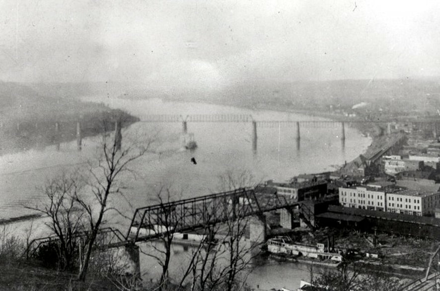
A late 1800s view taken from what is present day looking upstream along the Ohio. The 1871 bridge presents a solitary appearance as the only span crossing the Ohio River at this date. In the foreground is the original Ohio River Railroad bridge spanning the Little Kanawha River at its mouth. Both bridges look fragile and would ultimately be replaced as steam locomotives became larger and heavier. Dan Robie/John G. King collection
|
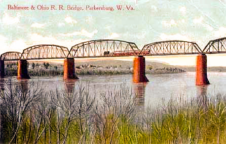
Early 20th century postcard with a train crossing the bridge. The new truss spans are in evidence dating this rendition to no earlier than 1905. Image courtesy Parkersburg WV-A Vintage Portrait
|
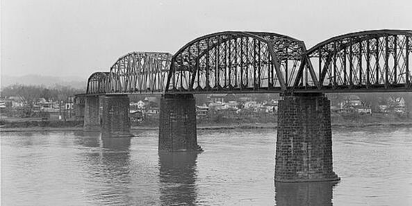
This 1973 photo clearly shows the silver truss span that was replaced after a barge struck a pier and exploded. The accident occurred in January 1972 and not only damaged the river bridges but buildings in Parkersburg and Belpre. Tragically, eleven persons were injured and two were killed. Photo William E. Barrett/Library of Congress
|
The Ohio River Bridge was replaced in two phases. First were the approaches built upon the original piers on both the Parkersburg and Belpre sides completed by 1900. This was followed by heavier truss spans over the river completed by 1905. Upgrading the bridge was a necessity due to steam locomotive development resulting in larger and heavier models. No significant modifications were done until 1972 when a barge struck a pier and exploded. As a result, an entire truss span was replaced with the bridge closed to traffic until repairs were completed.
|
Early B&O passenger train crosses the bridge in a photo that is perhaps circa 1875. The completion of the Ohio River bridge accelerated the westward expansion of the road. Image courtesy of Parkersburg WV-A Vintage Portrait
|
A 1967 view looking east into town from the Parkersburg bridge approach. An impressive bridge by any measure and the deep blue luster on the rail heads indicative of heavy train traffic. Image courtesy Parkersburg WV-A Vintage Portrait
|
The primary B&O Parkersburg passenger station was located just east of the Ohio River bridge on the block bounded by Green and Avery Streets. Constructed in 1883 of Victorian design, this brick structure hosted thousands of passengers traveling east and west for nearly ninety years. As with many stations across the country, once passenger rail declined these structures were neglected often falling into disrepair before facing demolition. The B&O station was razed in 1973 in an era before preservation efforts gained favor. When Amtrak service returned to the city from 1976-1981, a small “Amshack” trailer was used for passengers. Parkersburg was a major stop for the B&O on the St. Louis mainline despite its mid-sized city status in regards to population. All of the long distance trains called as well as the secondary ones. On a route that was sparsely populated, B&O needed passenger base wherever it could be found. The other station in Parkersburg at Ann Street served the Ohio River line and this structure will be included in a future piece about the Ohio River line.
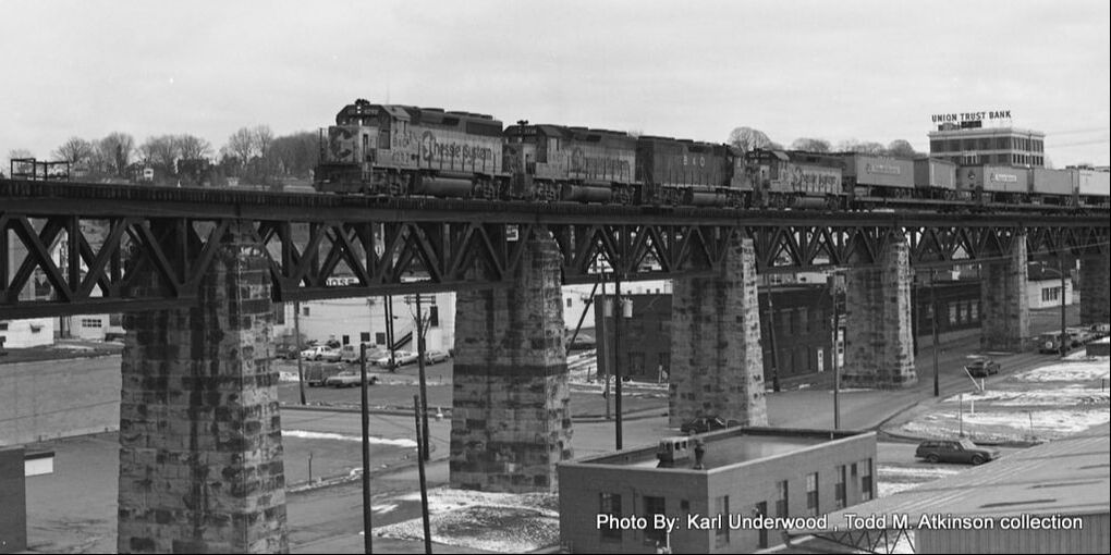
Crew change completed, the St. Louis Trailer Train heads across the Ohio River bridge in this circa 1980 photo. This TOFC (trailer on flatcar) hotshot will continue its trip across Ohio, Indiana, and Illinois until terminating at Cone Yard in East St. Louis. Image Karl Underwood/Todd M. Atkinson collection
|
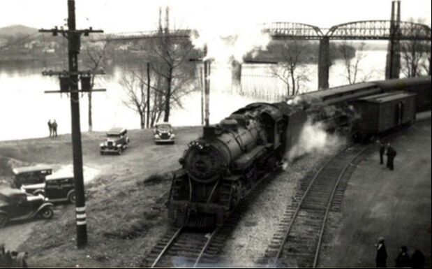
P3 Pacific #5100 runs the transfer track along the Ohio River near the mouth of the Little Kanawha. This is the connection between the B&O mainline and the Ohio River Line. The automobiles date this image circa 1930s. Dan Robie/John G. King collection
|
A westbound view of the B&O station circa 1930s. The photographer obviously stood on the mainline track and framed this scene rather nicely. This curve at the station was among the sharpest on the route. Image courtesy Parkersburg WV-A Vintage Portrait
|
|
Activity abounds with Train #76, the Cincinnatian, stopped at Parkersburg for both passengers and a crew change. The engineer is climbing aboard the streamlined P7d Pacific #5304 for the trip east over the Parkersburg Branch to Grafton. This classic scene, circa 1948, captures an era that would end all too soon. Image courtesy Adam Burns collection
|
A 1950s view looking eastward at the B&O station. The photographer gets bonus points for including the train of coal empties probably moving eastbound to a mine somewhere on the Monongah Division. Image courtesy Parkersburg WV-A Vintage Portrait
|
Steam was in its twilight when this June 1956 photo of Train #23, the West Virginian, captured its arrival at Parkersburg. Although lacking the stature of the National Limited and Diplomat, this train filled the niche of serving all the whistle stop communities along its route. Photo Richard J. Cook/courtesy Allen County Museum All rights reserved.
|
The B&O station in its twilight circa late 1960s. Few passengers (or trains) remained by this date as the glory years had long since passed. Not preserved as a landmark, the structure vanished beneath the bulldozer tread in 1973. Image courtesy Parkersburg WV-A Vintage Portrait.
|
Train time during the late 1970s at Parkersburg. The eastbound Shenandoah is stopped and it looks like a handful passengers await. Note the "Amshack" trailer used in lieu of the now gone B&O station. Dan Robie/John King collection
|
|
The date is May 5, 1973 and although the E8 is painted for the B&O, it is now the era of Amtrak. A rather leisurely scene at the station platform as the Potomac Special awaits its eastbound departure. Image courtesy Parkersburg WV-A Vintage Portrait.
|
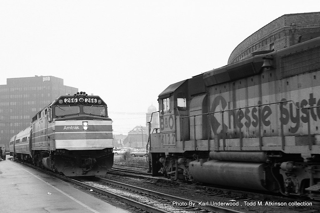
Amtrak FP40HR #266 has stopped at Parkersburg with Train #32, the Shenandoah, in this 1980 scene. At right a westbound train led by B&O GP40-2 #4127 waits to depart. Image Karl Underwood/ Todd M. Atkinson collection
|
The center of Parkersburg operations along the mainline was the “High Yard". Consisting of more than 36,000 feet of storage capacity, this was the primary classification point for inbound and outbound freight cars both to points east and west and for the industrial base in the Parkersburg area. In its prime, the yard was complete with a roundhouse and turntable during steam era operations but still remained in use with the onset of diesels. A transfer track diverged from the high yard for trains to connect with the Ohio River line and "Low Yard". Always an integral connection between the two B&O lines, the transfer track took on extra significance during the 1963 tunnel project between Parkersburg and Clarksburg. Rerouted trains over the Short Line and Ohio River line used this track to reenter the mainline to proceed westward through Ohio. Eastbound trains did likewise except in reverse order.
|
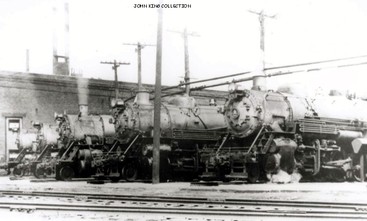
This was the treasured scene that awaited a visitor at the Parkersburg radial in 1950. Q Class Mikados ready for duty on The Branch and elsewhere on the Monongah, Wheeling, and Ohio Divisions. Dan Robie/ John G. King collection
|
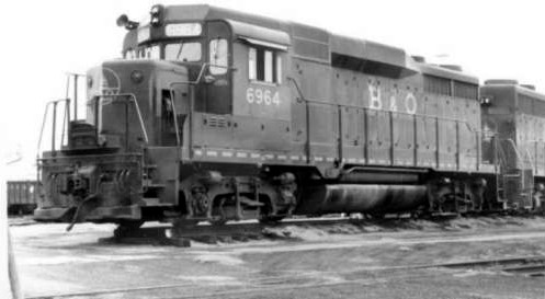
GP30 #6964 and a mate at Parkersburg in 1970. This is a "hybrid" locomotive in that it shares a mid 1960s Gothic lettering scheme with the "Sunburst" conspicuity lines on the side. Not uncommon during this era. Dan Robie/ John G. King collection
|
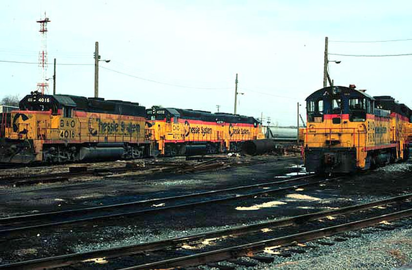
Chessie cats at the roundhouse service area in 1983. The Parkersburg terminal provided supplemental power for mainline trains in addition to local and yard jobs. Image courtesy Dave Dupler.
When the St. Louis mainline was downgraded and the Parkersburg Branch severed, the High Yard in effect became the secondary yard. Since through trains were no longer passing, the operation shifted to car storage and a staging point for the coal trains crossing the river to the power plant at Relief, OH. Local traffic destined for industries in Belpre also originated here. Initially, the former mainline remained intact east to Walker to service Westvaco Lumber. Once operations ceased there, the former mainline track was subsequently removed from Walker to just east of the Parkersburg city limit at Stewart. In reality, the sever point is now located at the east end of the High Yard.
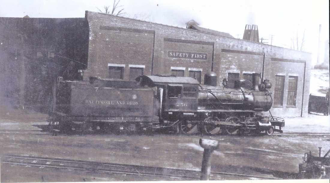
B&O Class B-54 4-6-0 #256 at the Parkersburg roundhouse circa 1920. The Ten-Wheelers were the passenger power early in the century until displaced by the 4-6-2 Pacific. The 4-6-0s did survive in secondary service into the twilight years of steam. Image courtesy Ken Adams/North Bend Rail Trail Foundation.
|
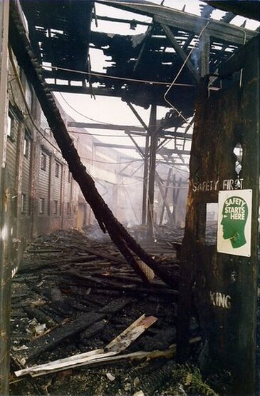
Left: On August 20, 1989 the Parkersburg roundhouse was destroyed by fire--a most ignominious end to a historic structure---determined as an act of arson. As this and the image below attest, the damage was devastating. The "safety first" slogan and sign stand out in stark irony. Image courtesy of Todd M. Atkinson.
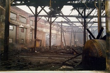
Another view of the destruction. Not much remained except for the steel structural skeleton and the brick walls. Image courtesy of Todd M. Atkinson
|
In 1989, the Parkersburg roundhouse burned to the ground, a target of arson. In addition, the turntable was removed preventing the turning of locomotives to lead in which direction was necessary. The loss of the roundhouse and turntable was a symbolic ending of the B&O/Chessie transition to CSXT coinciding with the loss of the mainline. Locomotive turning has since been done on the wye across the river in Belpre as needed.
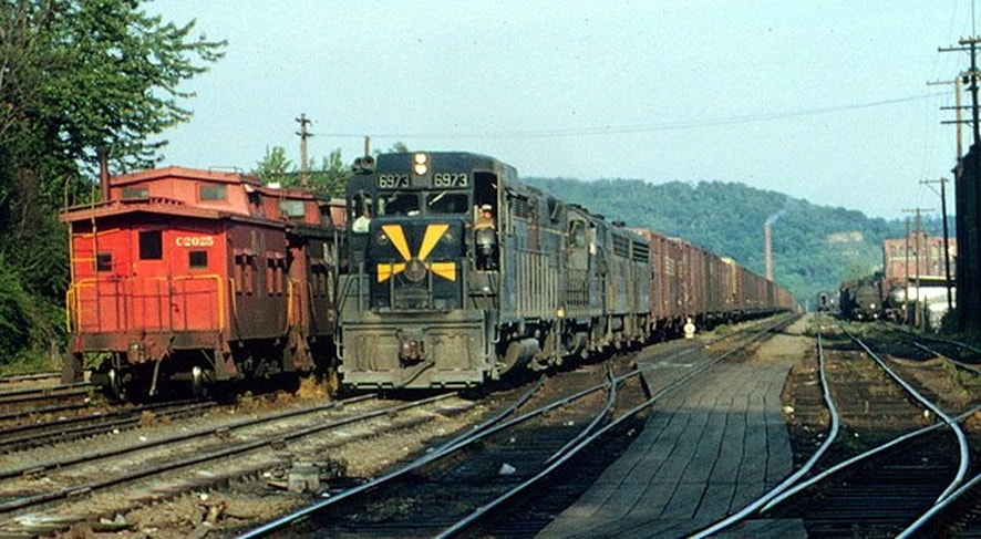
Parkersburg as it was a half century ago. GP30 #6973 leads a paused Cincinnati 97 at OB Tower in the High Yard on a glorious summer day in 1964. The wood C6 class cabooses further sweeten this image. Both B&O and its mainline have long since perished but scenes such as this preserve the memories for posterity. Image courtesy Dave Dupler/Art Markley collection.
|
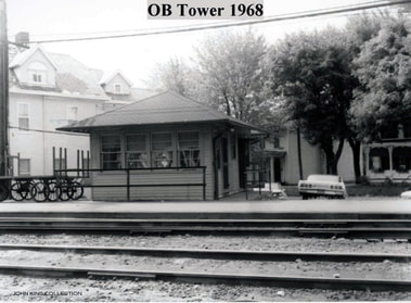
OB Tower at the High Yard in 1968. This was the central control point of operations in the yard. It was also the crew change point for Monongah and Ohio Division crews. At one time this structure had a second story. Dan Robie/ John G. King collection
A scene planted firmly in the Chessie System era. A yard job goes about switching as a westbound manifest (Cincinnati 97 or Gateway 97) is prepared for the resumed trip west. Image courtesy Dave Dupler
|
A dreary 1982 winter view looking east through a bare High Yard and at OB Tower. Note the track reduction in this scene as compared to the 1964 image above. Image courtesy Dave Dupler/Art Markley collection
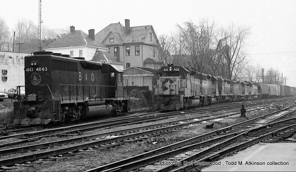
View looking through the mist of the day---and time---at a westbound manifest picking up or setting off a block of cars. This is probably Cincinnati 97 as GP40 #4063 idles on an adjacent track. Image Karl Underwood/Todd M. Atkinson collection
|
Parkersburg once flourished with heavy industry which generated carloads of traffic for B&O. Although most industry was related to oil and gas, a substantial amount of various manufacturing existed in the region as well. Chemicals at DuPont plant in Washington and the Shell refinery in Belpre, OH increased rail traffic proportionately as did the American Viscose Corporation. A listing of the shippers served by the B&O from the main line and High Yard during the 1940s is extensive: US Quarry Tile Company, Corning Glass Company, Vitro Agate Company, Standard Oil Company, Pure Oil Company, Cut Rate Lumber Company, Union Live Sales Stock Company, Kieckhafer Container Corporation, WV State Road Commission, Parkersburg Rig and Reel Company Plants #3, #4, and #6, Acme Fishing Tool Company, Parkersburg Grocery Company, Northrup Equipment Company, Monongahela Power Company, Parkersburg Mill Company, Citizens Coal Company, Citizens Lumber Company, Ohio River Sand and Gravel Company, Southern States Corporation, Peerless Milling Company, Parkersburg Distributing Company, Parkersburg Storage and Transfer Company, Ideal Corrugated Box Plants #1 and #2, Plate Construction Company, Parkersburg Tri-Pure Water Company, Central Distributing Company, Graham Packing Company, Berdine Brothers, Spur Distributing Company, Parkersburg Rig and Reel Company #2, Grossman Shoe Company, Citizens Transfer and Storage, Universal Supply Company, and the Berry Hatchery.
|
SY Tower, the guardian of the east end of the Parkersburg High Yard at an unknown date. When this tower was closed, all yard control was shifted to OB Tower at the west end of the yard. Dan Robie/John G. King collection
A forlorn 2002 view of what remains of the Parkersburg Branch east of the High Yard. The former mainline is but a stub for car storage extending past the location of where SY Tower once stood. Image courtesy of Adam Burns
|
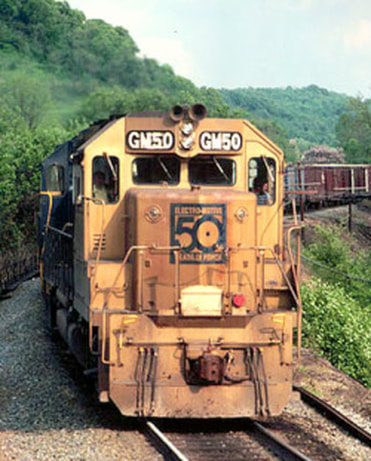
Perhaps the most noted of the Chessie System locomotives, the gold GP40-2 GM50. Here it leads Gateway 97 west near the former location of SY Tower in 1979. Image courtesy Dave Dupler/Art Markley collection
B&O fans and historians of the Parkersburg Branch/St.Louis mainline owe a debt of gratitude to the memory of the late Art Markley. Images of this line are scarce compared to other B&O regions and we are grateful Mr. Markley spent time trackside here. Special acknowledgement is also due Dave Dupler for making Art's work visible for all to see. |
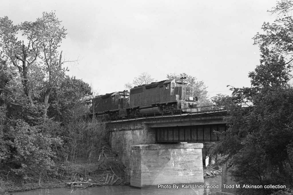
B&O GP40-2 GM50 again passes through Parkersburg on a run over the St. Louis main this time on the point of a St .Louis Trailer Train. It is crossing over Worthington Creek preparing to enter the High Yard. Image Karl Underwood/Todd M. Atkinson collection
Not unlike other industrial centers, the Parkersburg region declined in the latter 1900s as heavy manufacturing closed, downsized, or was lost to imports. The area today is still busy but certainly not with the number shippers as in past years.
Along the Little Kanawha
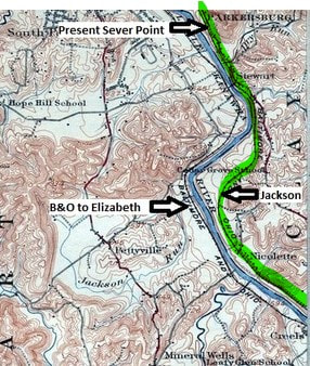
Moving east from the limits of Parkersburg, the B&O main line (green) paralleled the Little Kanawha River and State Route 47 for roughly eight miles. Along the way, it passed through small communities such as Stewart, Jackson, and Nicolette. Of note is Jackson where the first passing siding east of Parkersburg was located.
B&O also occupied the opposite bank of the Little Kanawha as well until the route was abandoned in 1937. This is the branch line that followed the river to Elizabeth as seen on this sector of a 1904 topo map.
B&O also occupied the opposite bank of the Little Kanawha as well until the route was abandoned in 1937. This is the branch line that followed the river to Elizabeth as seen on this sector of a 1904 topo map.
East of Parkersburg, the B&O mainline followed the comparatively level terrain of the Little Kanawha River in contrast to the small gradients it would encounter to the east. Once clear of the of the east end of the Parkersburg High Yard and SY Tower, single track main crossed Worthington Creek and remained so until reaching the first passing siding at Jackson (JA Tower). In the pre CTC days, an operator was stationed there.
|
The Philadelphia Trailer Train races eastbound near Stewart circa 1983. B&O GP40-2 #4427 is on the lead as this class of locomotive was common on this and most Chessie System trains. The Parkersburg Branch as a through route had only a couple of years left by this date. Jerry Doyle photo
|
Cumberland 94 runs east near Nicolette with a combination of F7A and B units on the lead. The year is 1974 and these noble but tired locomotives are on their last revenue run before being traded in to EMD for new power. Dan Robie/John G.King collection
|
|
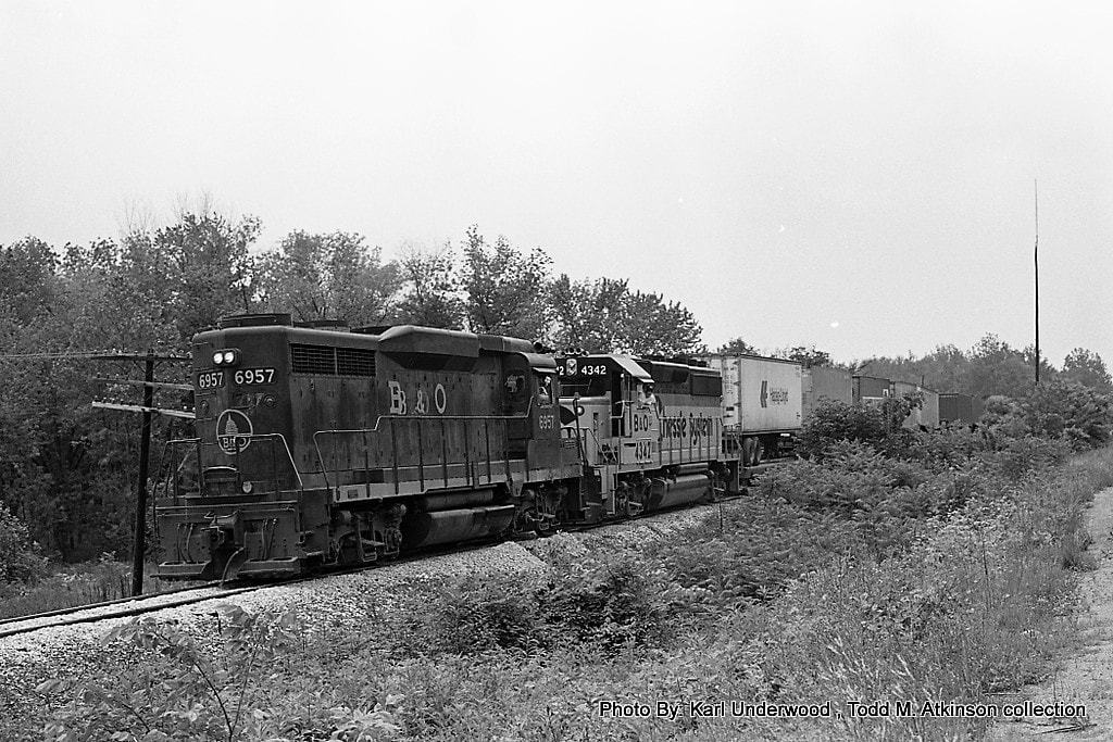
A story here with the eastbound Wilmington Trailer Train lost to time. The lead locomotive on this train must have failed leaving GP30 #6957 in the lead long hood forward. Perhaps no unit was available at Parkersburg to add on so this train ran at least to Grafton like this. Image Karl Underwood/Todd M. Atkinson collection
|
This 1992 image looks westbound at the abandoned mainline between Stewart and Nicolette. It was not long after this photo was taken that CSX removed the remaining segment between Parkersburg and Walker. Requiem for the route of the National Limited. Dan Robie 1992
|
There was very little in the way of industry along this stretch of track. Once east of Parkersburg, the Branch became essentially single track mainline with on line shippers sporadically spaced. One exception was at Stewart with the US Quarry Tile Company located beyond the east Parkersburg yard lead at SY Tower.
The railroad in this region east of Parkersburg was readily accessible and a number of photos have appeared from this area. If the line were still active today, it would no doubt be popular with untold numbers of digital images taken. Today, however, only roadbed remains and the western terminus of the North Bend Rail Trail is located in the vicinity of Happy Valley.
The railroad in this region east of Parkersburg was readily accessible and a number of photos have appeared from this area. If the line were still active today, it would no doubt be popular with untold numbers of digital images taken. Today, however, only roadbed remains and the western terminus of the North Bend Rail Trail is located in the vicinity of Happy Valley.
An eastbound Philadelphia Trailer Train holds the siding at Jackson in this circa 1980 photo. It must have been another priority train en route such as Gateway 97 or the St. Louis Trailer Train for this train to take the siding. Image Karl Underwood/ Todd M. Atkinson collection
|
Eastbound view of the former mainline and the recent removal of the north passing track siding at Jackson. This area lies between Stewart and Nicolette. Dan Robie 1990
|
West view from the west end of the former siding at Jackson. The CPL has been turned away from the track since mainline has been severed, A little shine on the rails from trains still running to Westvaco at Walker. Dan Robie 1990
|
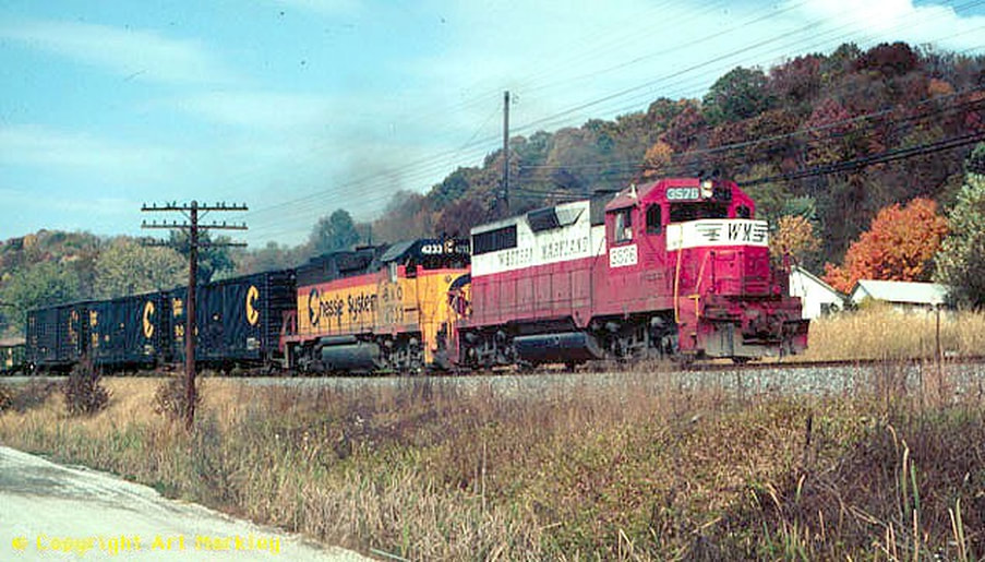
Western Maryland power added its own touch of class and color during the Chessie System era with GP35 #3576 leading B&O GP40-2 #4333 near Nicolette. The year is circa 1979 and the train is Cumberland 94 running east on the Parkersburg Branch towards Grafton. Image courtesy Dave Dupler/Art Markley collection
Davisville Towards Walker
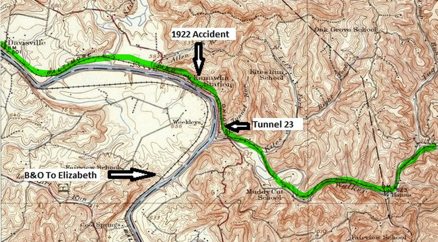
The Parkersburg Branch (green) continues to follow the cozy confines of the Little Kanawha River from Davisville to just past Kanawha (Station). At the mouth of Walker Creek, the railroad turns east and follows the stream to the town bearing the same name. With the flat river valley now behind, the line begins the trek through its toughest stretch between Parkersburg and Clarksburg.
|
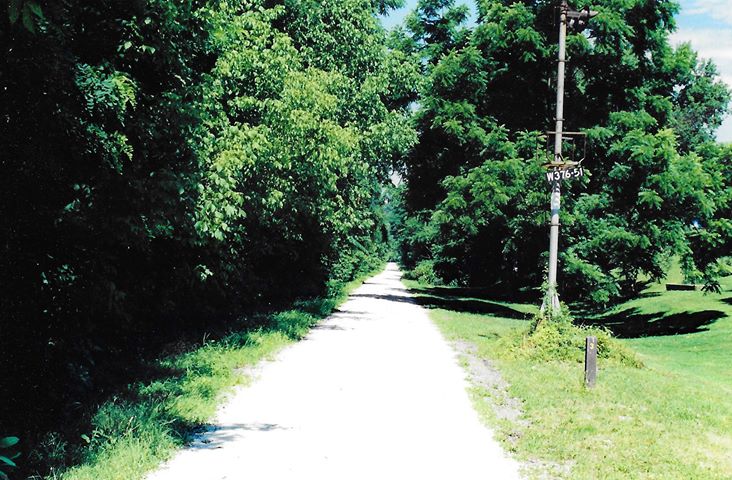
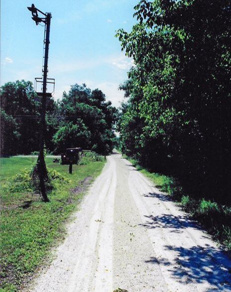
Two views taken of the abandoned right of way at Davisville looking west and east, respectively. When these 2002 photos were taken, the track here had only been removed within the decade. The gutted CPL which once governed movements for uncounted trains stands as a solemn relic but still identifying the location as Milepost 376.5. Both photos courtesy of Adam Burns
|
Although the railroad paralleled the Little Kanawha River east of Parkersburg, it meandered away from it directly to avoid the sharp bends. At Davisville, it returned to the waters edge and remained so before leaving the valley east of Kanawha at Walker Creek. The only recorded shippers of consequence located in this area were the Ames True Temper distribution facility at Davisville and Stillwell Tie Hoist Siding at Kanawha; if there were others, they disappeared early in the 20th century.
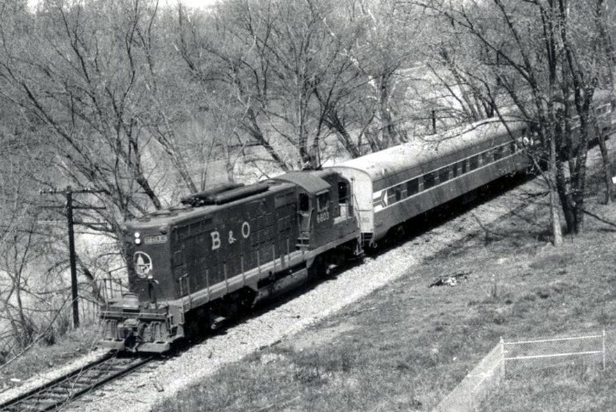
The Potomac Special runs eastbound along the Little Kanawha River near Davisville in 1972. B&O GP9 #6603 is equipped for passenger service with heat generators. The air reservoir tanks are relocated on the roof which resulted in the moniker of "torpedo tube" for this variant of a GP9. Image Dan Robie/ John G. King collection
All of the passenger trains that traversed the Parkersburg Branch obviously passed through these communities but Davisville and Kanawha were flag stops only. The last timetable train that listed these locations as such was the original West Virginian that ran the route until 1958.
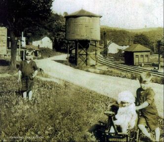
A remarkable image taken at Kanawha Station circa 1920. The three adorable children were the subject of this century old photo but the photographer was also kind to the rail historian. Frozen in time with the children is the railroad layout as it was in this small community complete with depot, water tank, and auxiliary siding. Image Dan Robie/ John G. King collection
|
Kanawha Station was located along the river as opposed to the community (Kanawha) which is centered alongside WV Route 47--roadway of the original Staunton-Parkersburg Turnpike. At one time, this was the location of a passing siding and block station but its importance apparently had dwindled by the mid 1900s. B&O lists the block station (call letters KA) still active as of 1928 but gone by the beginning of World War II.
Interstate Commerce Commission (ICC) archives record an accident at Kanawha on August 13, 1922 that resulted in the death of the engineer. A westbound extra with E27 Consolidation (2-8-0) #2543 and twenty four cars plus caboose was running at 25 MPH one mile west of town facing directly into the sun. Due to sun glare, the engineer and fireman could not see a switch was aligned against the mainline and the train diverged into the siding. The engineer applied the emergency brake before jumping from the locomotive---he died as a result of the injuries. A single car in the siding was destroyed by the #2543 and several cars further west on the track were damaged. The locomotive was not damaged but several cars in the consist behind it derailed. Follow up investigation determined that the switch lock had been broken off with a rock and the switch points lined for the siding. Two young boys, ages 7 and 11, were at the location prior to the train arriving and authorities questioned them until they admitted tampering with the switch. One can only wonder how this act of mischief and the resulting loss of life affected the remainder of their lives. |
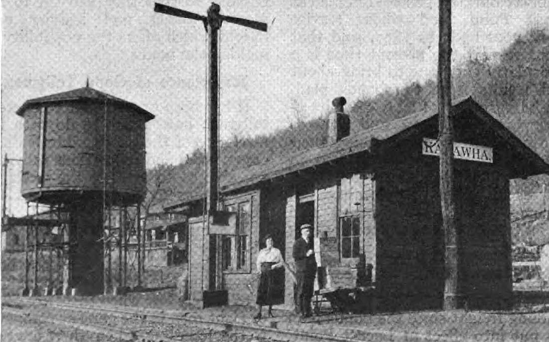
Kanawha Station depot as it appeared in 1921. Symbolic of all the place name locations of the golden era equipped with a station agent and other facilities as needed such as the water tower. B&O Magazine Archives
Extremely rare photo of a look at the long lost Tunnel #23 at Kanawha in 1922. This view looks eastbound at the west portal of a tunnel that was daylighted in 1943. The Little Kanawha River is at right. Photo B&O Magazine Archives
|
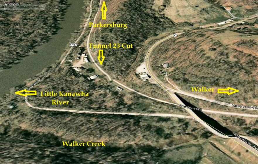
A 2003 Google Earth capsule outlining the location of the long lost Tunnel 23. The cut is no longer sharply defined as additional excavating of the area has taken place throughout the years since 1943. As B&O was daylighting the tunnel, it built a shoo-fly track around it to keep trains moving along its mainline corridor in World War II America. Tunnel 23, also known as Farrell's Tunnel, was relatively short in length at 287 feet.
|
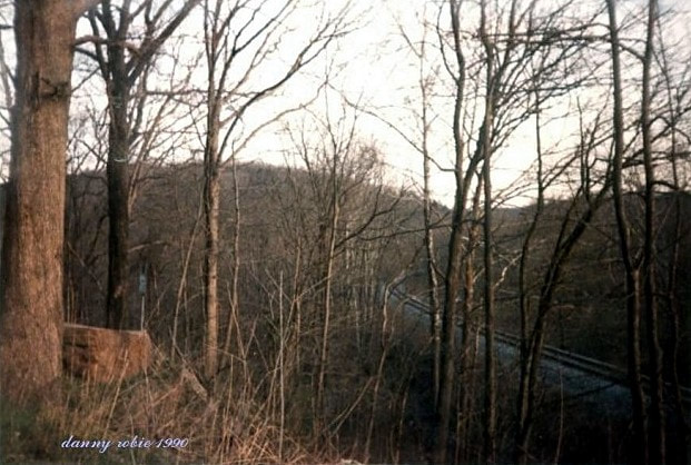
Eastbound view from above of the former B&O mainline east of Kanawha. This location is where WV Route 47 and the railroad parted company in the Little Kanawha River valley. The headlight of a westbound train piercing through the trees would have made for a fine addition here. Dan Robie 1990
|
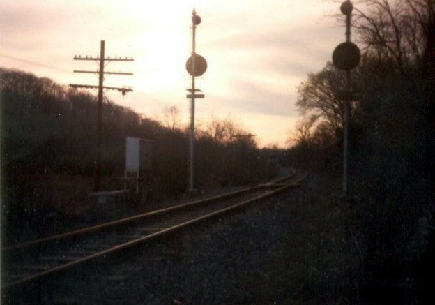
B&O color position lights (CPLs) stand dark vigil over the former mainline between Kanawha Station and Walker. Curiously, this pair had not been turned to face away from the track since they were unnecessary. This 1990 image captures the railroad at sunset literally and figuratively in the twilight of its existence. Dan Robie 1990
|
|
The former main line looking east towards Walker. Looks are deceiving with the well manicured ballast but in reality, simply a spur from Parkersburg to Walker. Within a few years, this too would be gone. Dan Robie 1990
|
The girder plate bridge across Walker Creek at Hannah. A view looking eastbound shortly after the track was removed from Parkersburg to Walker. Dan Robie 1994
|
In 1943, B&O undertook its first tunnel clearance project, a precursor to the one that would occur two decades later on a grander scale. Tunnel #23, the westernmost of the group on the Parkersburg Branch, was among the shortest at 287 feet. The problem it presented to the B&O was not a clearance issue but a maintenance nightmare. Located on the curve at the mouth of Walker Creek, it was susceptible to high water from the Little Kanawha River. The solution was to daylight the tunnel and improve the right of way to better protect it from flooding. So serious had been the issue that B&O completed this project during mid World War II when traffic volume was chaotic and other line of road improvements postponed.
Walker to Petroleum
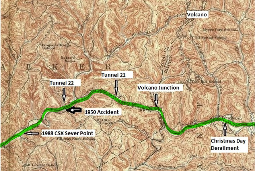
A 1926 topo map of the B&O main line from Walker to Petroleum. The railroad followed Walker Creek then passed through Tunnel 22. At Eaton, the line bored through Tunnel 21, the divide between the Walker and Goose Creek drainages whence the railroad paralleled the latter to Petroleum. In the late 19th century, Petroleum was near a junction for the Laurel Fork and Sand Hill Railroad which straddled the Wood-Ritchie County line to the boom town of Volcano. The map area is expanded here as to include it.
Walker
Once outside the railroad sphere of Parkersburg, the town of Walker begins a stretch of small hamlets and communities that populate the Parkersburg Branch for the next seventy miles until reaching Clarksburg. Each had its own charms and characteristics with varying degrees of importance to the railroad that was an integral part of the landscape for one hundred thirty years.
|
This circa 1980 image of Westvaco is a double bonus. Not only are the pulpwood cars visible on the yard but a coal train waits in the siding at Walker for a meet. Image courtesy MeadWestvaco
|
A view inside the collection yard at Westvaco. This view faces eastbound along the B&O main line. Image courtesy MeadWestvaco.
|
Walker was the location of a block station (B&O call letters WA) and passing siding. The most notable on line shipper for the B&O was Westvaco which constructed a lumber collection yard there in 1960. After the B&O mainline was abandoned between Walker and Wolf Summit in 1985, Westvaco continued to operate for several more years at the site until shifting its operation to Millwood along the CSX Ohio River Sub.
|
The B&O layout at Walker during the early 1900s. This was a combination structure that served as a depot and office. Dan Robie/John G. King collection
|
A gutted CPL signal stands as a ghost from the past at the location of the former passing siding at Walker. All that remains of the signal face is the frame--the lenses and housing were removed or destroyed. Dan Robie 1994
|
|
A Depression era scene taken at Walker. The railroad depot is visible at top left center and a siding can be seen diverging from the mainline. View is somewhat to the east and the open area on the opposite side of the tracks is where Westvaco would locate its pulp yard in 1960. Image courtesy North Bend Rail Trail Foundation.
|
Another view by the same photographer south of the image at left. Bridge #47 crosses Walker Creek and through the leafless trees can be seen the mainline and switch for the passing siding. Image courtesy North Bend Rail Trail Foundation.
|
It was at Walker in March 1988 that track crews with torch in hand and wreck out train in support first cut the rails that forever severed the B&O St. Louis main line. Thus began the steady removal of track between Parkersburg and Clarksburg that would continue with sectionalized severing in Ohio between Belpre and Cincinnati over the course of the next couple of years. Once Westvaco ceased operations during early 1990s, CSX removed the remaining stub of track from Walker to the east end of Parkersburg.
Between Walker and Eaton was Tunnel 22 also known as Rodemer's Tunnel. At 338 feet and with no hindrances, B&O opted to bypass the 338 foot long bore with a cut rather than improve its clearance. It is one of three that was bypassed during the 1963 project. Tunnel 22 was the site of a recorded ICC accident that occurred on June 30, 1950. At 3:25 PM, Train #29, an unnamed westbound mail and express, passed a clear signal approximately 1300 feet from the east portal of Tunnel 22 and entered the bore at 48 MPH which exceeded the 45 MPH limit of this section of railroad. The train was double headed with two 4-6-2 class Pacific locomotives, numbers #5301 and #5048. The total consist for the train was sixteen cars of various types including coach, baggage, and refrigerated express cars.
Between Walker and Eaton was Tunnel 22 also known as Rodemer's Tunnel. At 338 feet and with no hindrances, B&O opted to bypass the 338 foot long bore with a cut rather than improve its clearance. It is one of three that was bypassed during the 1963 project. Tunnel 22 was the site of a recorded ICC accident that occurred on June 30, 1950. At 3:25 PM, Train #29, an unnamed westbound mail and express, passed a clear signal approximately 1300 feet from the east portal of Tunnel 22 and entered the bore at 48 MPH which exceeded the 45 MPH limit of this section of railroad. The train was double headed with two 4-6-2 class Pacific locomotives, numbers #5301 and #5048. The total consist for the train was sixteen cars of various types including coach, baggage, and refrigerated express cars.
|
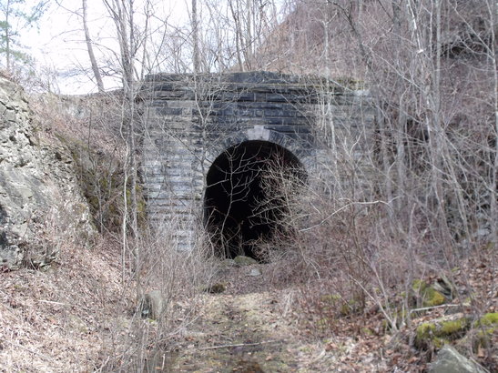
West portal of Tunnel 22. Image courtesy North Bend Rail Trail Foundation
|
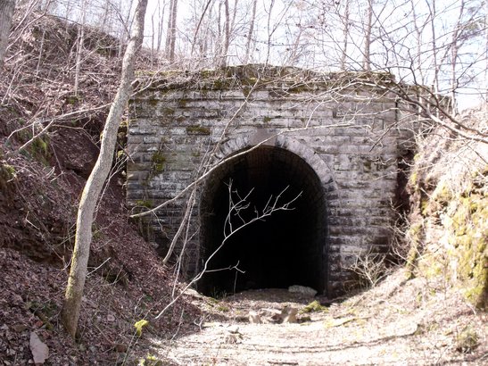
East portal of Tunnel 22. Image courtesy North Bend Rail Trail Foundation
|
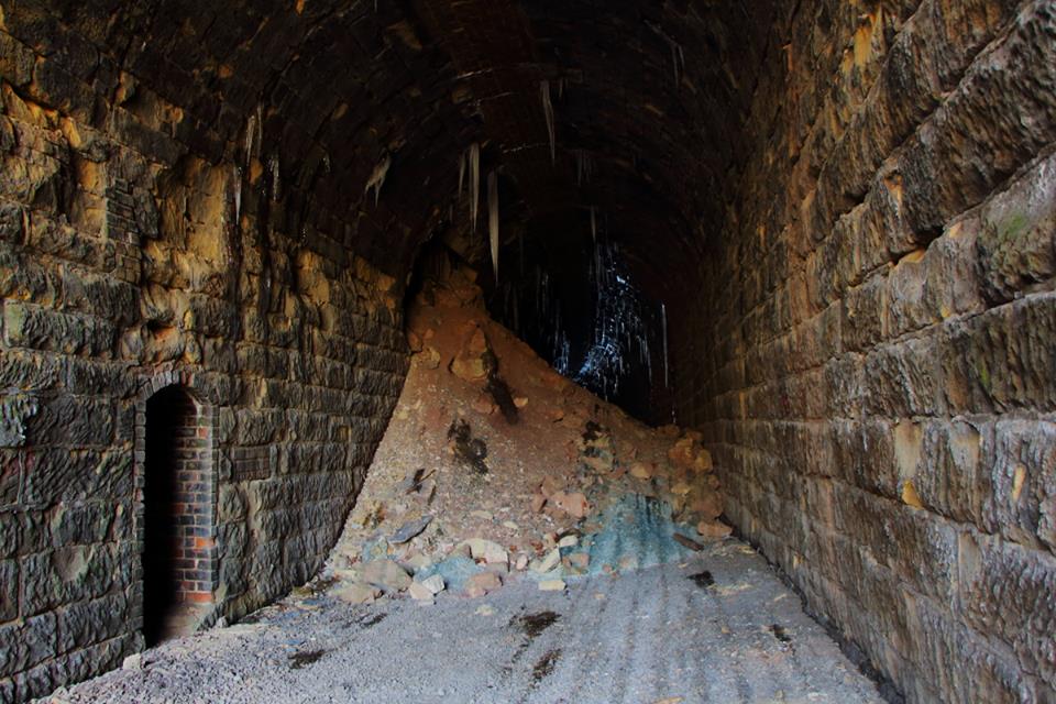
Upon entering the tunnel, the engineer of the lead locomotive heard a sound indicative of a broken rail and the train began to derail before the brakes could be applied. Both locomotives derailed to the right moving along the north wall of the tunnel and derailed to the right after exiting the west portal. Both locomotives sustained considerable damage as did the first three cars. The north wall of the tunnel was heavily damaged and the track inside destroyed. The engineer in the second locomotive was killed and the engineer and fireman in the lead locomotive sustained injuries. A railway express employee also sustained injury. Train #12, the eastbound Metropolitan Special, had passed through Tunnel 22 forty-five minutes earlier and reported no unusual conditions. All equipment was determined to be in good order at the time of the accident. The ICC conclusion was the derailment was attributable solely to a broken rail.
Icicles formed by water seepage through the tunnel line the ceiling in Rodemer's Tunnel in the frigid cold of winter. Its solitude is broken only by the whistling wind that carries the whispers of ghosts and echoes of trains long since passed. Image courtesy Alan Nichols
Eaton
|
A 2003 Google Earth view of the location of Tunnel 21 at Eaton. This is the 1963 replacement for the old tunnel that tragically collapsed during the clearance project. The private property and road on the hill above the bore explain why B&O simply could not daylight all of the tunnels during the 1963 project. Hilltops on other tunnels presented the railroad with a similar situation.
|
Left: Rare image at Tunnel #21--then Bee Tree--taken in 1916. This scene is of the ventilator shaft installation in progress for the clearing of smoke and heat from the bore. It remained in service until being discontinued in the early 1930s. B&O Magazine Archives
|
Eaton was a flag whistle stop for secondary passenger trains for many years and a small dep was once located here. No online shippers were in existence---certainly not since the 19th century at the latest. The location was best known for Tunnel 21, one of the longest---and tragic---bores on the B&O system.
The concrete portal of brand new Tunnel #21 glistens as a Trailer Jet (perhaps the first one) passes through on October 29, 1963 in this B&O publicity photo. Eaton Tunnel was one of a series of clearance improvements made on the Parkersburg Branch in 1963 that opened TOFC (piggyback) service between New York and St. Louis. Photo Baltimore and Ohio Railroad
The original Eaton Tunnel (also known as Bee Tree) was brick lined at a length of 2020 feet and a nightmare for train crews during the steam era. Long and tight, the bore became an inferno filled with heat, smoke, and cinders as trains passed through it. It was one of three tunnels on the Parkersburg Branch that ventilation plants were installed circa 1916 with huge fans to alleviate the tortuous trip through the bore. The plant was installed at the west portal and manned by an operator who would light the boiler to provide the power for the fans. Block operators at Walker or Petroleum notified the ventilator operator as to the approach of a train depending on direction.
March 1988: Death of a railroad. The Parkersburg Branch begins its transition from railroad to dotted line on a map. Rail removal train moves through the east portal of Eaton Tunnel as the track removal is underway. The new Eaton Tunnel, constructed 1963, saw a mere 22 years of operational existence. Image courtesy of Alan Nichols
At this time, I wish to acknowledge Alan Nichols for the images above and the ones to follow moving east along the route. He had the foresight to document the removal of the Parkersburg Branch during 1988 realizing the historical significance. Needless to say, his input enhances this piece immensely from what it otherwise would be.
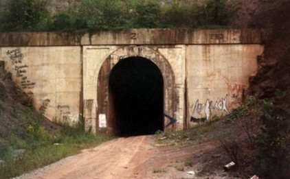
The east portal of Eaton Tunnel with "21" and "1963" stamped in its façade. Dan Robie 1991
During the 1963 tunnel project, the work commenced on Tunnel 21 to increase its clearance for TOFC (piggyback) trains and larger freight cars when disaster struck. The roof of the tunnel collapsed and trapped three workers inside in a mass of rubble. Because of the scope of the collapse, B&O deemed the repair effort futile and the decision was made to drill a new bore. It is appropriate here to mention the three workers because there seems to be conflicting information about these brave men. I have found sources that cite three men are entombed inside the old tunnel and others that list one with two having been removed with one surviving and the other succumbing to injuries. Since I am not positive as to which one is correct, both accounts are presented. In either scenario, it was a tragedy and the old tunnel is now a sealed tomb. The new Tunnel #21 completed in 1963 was still lengthy at 1840 feet but slightly shorter than the original. Being of more modern construction, the portals and lining are smooth concrete and contrast sharply with the other Parkersburg Branch tunnels in design and appearance.
During the 1963 tunnel project, the work commenced on Tunnel 21 to increase its clearance for TOFC (piggyback) trains and larger freight cars when disaster struck. The roof of the tunnel collapsed and trapped three workers inside in a mass of rubble. Because of the scope of the collapse, B&O deemed the repair effort futile and the decision was made to drill a new bore. It is appropriate here to mention the three workers because there seems to be conflicting information about these brave men. I have found sources that cite three men are entombed inside the old tunnel and others that list one with two having been removed with one surviving and the other succumbing to injuries. Since I am not positive as to which one is correct, both accounts are presented. In either scenario, it was a tragedy and the old tunnel is now a sealed tomb. The new Tunnel #21 completed in 1963 was still lengthy at 1840 feet but slightly shorter than the original. Being of more modern construction, the portals and lining are smooth concrete and contrast sharply with the other Parkersburg Branch tunnels in design and appearance.
A trio of Geeps in the early CSX "blue belly" rendition lead a rail train east of Eaton Tunnel as track removal continues. One wonders how the crews of these trains felt as this storied piece of railroad steadily disappeared behind them. Image courtesy of Alan Nichols 1988
Petroleum
In a state where the hills and valleys are graced with colorful town names, the rails of the B&O mainline were not exempt from such passage and touched upon a few of them. Moving eastward, we now come to one and another closely aligned with it during the late 1800s----Petroleum and Volcano.
The depot at Petroleum circa 1915. Typical of standard B&O architecture, this structure and others like it fulfilled multiple roles in small towns serving as a passenger and freight stations in addition to mail and telegraph. Truly the centers of the community. We can only guess as to why the man is leaning in the window but by looking at the casks and flour sacks on the platform, his work is not yet done. A rather stately house on the hill above. Image Dan Robie/John G. King collection
Shortly after the Northwestern Virginia Railroad was constructed through the area, the first oil fields were drilled in 1859. In fact, there is contention that this may have been the first well drilled in the United States predating the Drake well in Titusville, PA. Whether Petroleum can make the claim as the first one drilled may be debatable but what is not was the size of the field on which it sat. The region would soon thrive as the oil industry boomed attracting speculators from the Northeast seeking the riches it would create. By this name or any other, Petroleum earned the title.
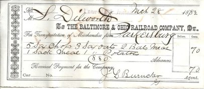
Payment from the Laurel Hill and Sand Hill Railroad to the B&O in the amount of 70 cents dated March 28, 1882. Produce shipped from Parkersburg to Volcano Junction for less than a buck. Image courtesy North Bend Rail Trail Foundation
In the immediate years following the Civil War, another huge oil field was discovered a few miles north of Petroleum at the town of Volcano. This strike created intense excitement as speculators moved and a town was seemingly built overnight. Wells sprang up everywhere at varying depths as the oil continued to flow. A great problem was realized that there was no efficient means to transport the black gold. There was no water transportation and the only answer was the construction of a railroad. A line was built and incorporated as the Laurel Fork and Sand Hill Railroad which connected to the B&O west of Petroleum at a point dubbed as Laurel or Volcano Junction. The builders of the railroad had grandiose plans of extending this line from Volcano to Marietta on the Ohio River but these dreams were never realized. Volcano was a boom town with nary any room for more extension and a pipeline from Parkersburg was constructed to transport the oil directly. Unfortunately, the prosperity of Volcano was short lived as the dreams literally went up in smoke. A catastrophic fire destroyed the town in 1879 and although some oil would continue to flow afterward, the glory was gone. The community was not rebuilt as the people and prosperity moved elsewhere and today it is a ghost town.
This circa 1910 postcard is the opposite view of the image above. Visible in this scene at Petroleum is the rear of the depot and the three story hotel that survived into the new millennium until consumed by fire. In the background two homes and the center of spirituality and small town charm---the community church. We thank Elizabeth for sending this card to a thoughtful recipient who in turn made available for future generations to admire. Image courtesy North Bend Rail Trail Foundation
B&O built a depot at Petroleum and as the railroad grew, it became the location of a block station manned by operators. The B&O call letters for this location were (UM) and a passing siding was located here for many years but its importance diminished over time. After World War II, it was no longer a block location as B&O had eliminated most with the implementation of Centralized Traffic Control (CTC) in 1951. The Petroleum passing siding disappeared from the employee timetable thereafter as a location for meets but remained listed as an agent siding in the early 1960s.
An eastbound view of the B&O mainline at Petroleum. This image is undated, perhaps circa 1940, but preserves a look of the layout with the depot and the westbound color position light (CPL) The days of the great oil boom were gone by this date but Petroleum still remained as a flag passenger stop for the B&O. Image courtesy Ritchie County Historical Society.
The incomparable Brooks Pepper, fifty year employee of the B&O and later contributor for "The West Virginia Hillbilly" magazine, recounted a story of a Christmas Day derailment that occurred near his home at Petroleum after he retired in 1968. I could find no official report on this derailment but the date is late 1960s-early 1970s. He had awakened that day only to see a train stopped on the mainline which his home faced. Mr. Pepper described it as having trailers and he ventured out on a bitter cold day to investigate. He told of finding the train sprawled across two bridge crossings of Goose Creek (Bridges 43 and 44) with cars scattered and derailed in the creek bank. The direction of the train was westbound --probably the St. Louis Trailer Jet-- and he found the crew unharmed but cold from the frigid weather. Soon, relief help was on its way to clear the mess that was determined to have been caused by a broken rail on Bridge 44.
If Brooks Pepper were still living in 1988, he would have been saddened by the sight of this rail train moving through Petroleum removing his beloved B&O in its wake. CSXT GP40 #6218 still adorned with the Chessie cat leads across Bridge 43 over Goose Creek east of town as the Parkersburg Branch steadily disappears behind it. Image courtesy Alan Nichols
Today, Petroleum harbors a field of memories from the past. The great oil fields are pages in history now just as is the Laurel Fork and Sand Hill Railroad that once connected it with the boom town of Volcano well over a century ago. And so, too, is the Baltimore and Ohio Railroad. But the North Bend Rail Trail continues to outline its existence as hikers and bikers traverse an area rich in lore.
Silver Run to Cornwallis
B&O followed the Goose Creek drainage to Tunnel 20 and continued to the crest at Tunnel 19 at Silver Run. From there, it dropped downgrade and paralleled Silver Run Creek to Cairo and the North Fork of Hughes River. A cluster of four more tunnels lay ahead before reaching Cornwallis. The town of Cairo and present day North Bend State Park are the familiar landmarks of this sector.
East of Petroleum, the railroad penetrated the first of six tunnels that lined the route to Cornwallis. Tunnel 20 was a short 254 feet in length and instead of working on this bore during the clearance project, B&O permanently solved the obstacle by daylighting it. A short cut exists where once Tunnel 20 stood.
Silver Run
Today there are a few homes scattered about in the vicinity of Silver Run but little remains to remind one of a tiny but busy hamlet that existed here a century ago. Situated at the crest of grades from either direction, it was a battlefield for trains fighting gravity for 130 years. In spite of the remote setting, Silver Run was enticing to photographers and a comparatively surprising number of images exist of the location spanning different eras.
|
Very rare old image circa 1900 of the small depot that was located at Silver Run. There was once a considerable amount activity in this small hamlet during the great oil boom era. Image courtesy of North Bend Rail Trail Foundation.
|
Foundation remains of SR Tower, block station once located at Silver Run. This image was taken from above the railroad roadbed. Image courtesy North Bend Rail Trail Foundation
|
The east portal of Silver Run Tunnel minus its bricked façade. Taken during the time of clearance project although from look of the track, line had not yet been closed. The "lady ghost" was surely curious about this work taking place. Image courtesy North Bend Rail Trail Foundation
Between Parkersburg and Clarksburg, the railroad passed through many a rural region but perhaps there was no location as remote as the outpost of Silver Run. In the era when a block station was located here, operators had to walk from the vicinity of Cairo to reach their place of work. At least at other locations, the sites were within townships providing easier access. Not so at Silver Run. For the third trick operator who manned the station during the dead of night, he surely felt that he was the last person on earth.
The Philadelphia Trailer Train exits the east portal of Silver Run Tunnel circa 1980. From the photographer vantage point, an image that testifies to the ruggedness of the area. More photos were taken at the east end of Tunnel 19 because it was easier to access than the west portal. Image Dan Robie/John G. King collection
Silver Run was among the more arduous locations operationally on the Parkersburg Branch and more so during the steam era. East of the tunnel was located the block station (B&O call letters SR) and passing siding that was situated on a grade. If a westbound train was held at the siding waiting for an eastbound to clear, it had to start from a dead stop on the grade and there upon enter Tunnel 19. Silver Run Tunnel was among the longest at 1376 feet and was not equipped with a ventilator fan such as Tunnel 21 at Eaton. Steam locomotives would enter the bore filling it with smoke, cinders, and intolerable heat as they pulled the train on the grade slowly gaining speed. These instances may have presented train crews the toughest operational situation on the Parkersburg Branch.
C&O SD40 #7516 exits Tunnel 19 with a coal train bound for the Haywood Power Plant north of Clarksburg in September 1976. The Parkersburg Branch is, oddly enough, not generally associated with coal traffic and an eastbound loaded train is even more of an anomaly. This exceptional image by the late Art Markley captures not only the contour of the grade but a line that has been refurbished with welded rail. Image courtesy Dave Dupler/Art Markley collection
|
Amtrak train #32, the eastbound Shenandoah, exits Silver Run Tunnel in this image circa 1978. The GE P30CH locomotives, nicknamed "Pooches" in rail circles, were standard power on these trains. Image courtesy Todd Atkinson collection.
|
Cumberland 96 exiting Tunnel 19 with B&O GP40 #3716 leading two other EMD sisters. This and other images from the same period reveal ties along the right of way pending replacement. Image courtesy Dave Dupler/Art Markley collection.
|
The paint is Chessie System but the locomotive number tells us that is now the CSX era. GP40 #6569 backs into Silver Run Tunnel shoving a wreck out train westbound through the bore. At this particular time, the track removal is taking place near Petroleum. One of the last images ever taken of a train at Silver Run. Image courtesy Alan Nichols 1988
|
Standing as a relic of a bygone era, this rusted CPL was once the westbound passing siding signal at Silver Run. The lapped sidings were to the east of Tunnel #19. Inexplicably, this signal mast was left in place. Image courtesy Adam Burns 2002
|
The same train exiting the seldom photographed west portal of Tunnel 19. A fascinating image taken from inside the bore that places into context the tightness of the confines if one was caught inside at the approach of a train. Note the retainer fence that blocks rock slips from landing on the track. Image courtesy of Alan Nichols 1988
|
Here is the #6569 preparing to run around the rail train at the Silver Run siding. All of the passing sidings on the Parkersburg Branch were utilized during the track removal. Once the trains moved west from Clarksburg, the power would lead the train to the last passing siding still in existence. The power would then uncouple and move to the rear of the train and shove it to the current working removal point. Since the power was already turned, the loaded train was ready for the return trip east. Note the excellent condition of this track soon to vanish. Image courtesy of Alan Nichols.
Silver Run......1963
|
Silver Run..... 2002
|
|
In a scene that dates from the era of the Tunnel Project, an eastbound Timesaver freight drifts downgrade past the siding at Silver Run. A work train also eastward facing holds in the siding until the hotshot train clears. Image courtesy North Bend Rail Trail Foundation
|
The hands of time can be both sad and startling. This 2002 image is close to the same vantage point as the photo above---this was taken from the grade crossing and CPL location midway in the circa 1963 image. An incredible contrast separated by 40 years. Image courtesy of Adam Burns
|
the Lady Ghost
It is only natural that the Parkersburg Branch with the time span of its existence and the mere nature of its topography would play hosts to apparitions and legends. The remote settings and the numerous tunnels provided fodder for such accounts and no location has more so than Silver Run and its lady ghost. For many years, railroad crews and operators alike reported seeing the specter of a woman with dark hair in a white dress along the railroad at Silver Run. Legend has it that she roams the right of way on the blackest of nights searching for her lost lover from long ago.
A major attraction of the North Bend Rail Trail is the exploration of the tunnels whether it be the physical structure or possibly the search for the unexplained--whether it be real or imagined. Tunnel 19 beckons the curious on both counts as a highlight of the Rail Trail and Parkersburg Branch lore.
A major attraction of the North Bend Rail Trail is the exploration of the tunnels whether it be the physical structure or possibly the search for the unexplained--whether it be real or imagined. Tunnel 19 beckons the curious on both counts as a highlight of the Rail Trail and Parkersburg Branch lore.
Cairo
Yet another town along the Parkersburg Branch with a unique name---shared with a city in Egypt and one in Illinois where the Ohio meets the Mississippi----is the community east of Silver Run. Cairo (in this instance pronounced Ker-ro), former oil boom town along the banks of the North Fork of Hughes River, is rich in early industrial and railroad history. B&O was the major player but the short line railroads of the town and region served were colorful enterprises.
|
An 1890s view of Cairo during its oil boom heyday. At the top can be seen the town center and the B&O truss bridge across the North Fork Hughes River. To the right is the Cairo and Kanawha Valley Railroad with cars for and from the B&O. The oil derricks are scattered about town affirming that a substantial amount of oil lay beneath Cairo. Dan Robie/John G. King collection
|
A "shoo-fly" trestle has been temporarily constructed to replace the North Fork of Hughes River bridge that collapsed. This 1890s oil boom image of Cairo looks eastbound and is filled with detail. Note the Bank of Cairo has not yet been built. Image courtesy Ritchie County Historical Society.
|
The 1850s were a period of fossil fuel discovery in this region of West Virginia. Coinciding with the oil boom along the Little Kanawha River at Burning Springs, a lesser known find took place along the North Fork of the Hughes River near Cairo. Veins of a substance similar to coal was were found here which also had qualities of oil because it burned for a longer period of time. This compound, later determined to be a natural form of asphalt, drew speculators from the East in search of riches. Unfortunately, the onset of the Civil War postponed these ambitions for a decade.
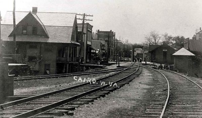
A westbound view along the B&O at Cairo during the early 1900s. The depot is visible in the distance at right as is the new truss bridge across the river. In the left distance is the new Bank of Cairo and in the foreground diverging left are the tracks of the C&KV. A thriving community in this era. Dan Robie/John G. King collection
|
The Town of Cairo did not go unscathed in regards to derailments. In 1915, a manifest train derailed causing substantial damage in the town center. The Cairo and Kanawha Valley Railway freight house seriously damaged. One railroad employee was killed in the accident. Image courtesy North Bend Rail Trail Foundation.
|
Once the hostilities ceased, the speculators returned to Cairo in quest of mining the asphalt not only as a fuel source but for use in paving roads. The major obstacle, as it was during the early industrial period was transport. Of course, the practical solution was by constructing a railroad. Enter the first short line to connect with B&O at Cairo, the narrow gauge Calico Railroad. From the junction with B&O at Cairo, the Calico followed the North Fork of the Hughes approximately twenty miles to the Ritchie Mines, source of the asphalt veins. Passenger cars were eventually placed into service and throughout its short existence the Calico provided vitally needed transportation for both workers and residents of southern Ritchie County. In turn, the short line funneled both people and commerce to the B&O most of which moved eastward. The beginning of the end for the Calico Railroad came in 1876 when tragic explosions at the Ritchie Mines effectively ended its reason for existence. Attempts were made to renew the mining but decline and exhaustion prevailed. Shortly thereafter, the railroad was abandoned and the rails removed. But this right of way would carry trains once again before the turn of the century.
An eastbound B&O manifest, possibly Cumberland 96, crosses the girder plate bridge at it passes the Bank of Cairo in this circa 1980 image. B&O GP40-2 #4339 leads several other EMD units on this vintage Chessie era consist. This scene also presents the trackside layout at Cairo with the grade crossing flashers, the westbound CPL, signal box, and excellent track condition. In addition to the photographer, the train has another interested onlooker at the bank. Scanned image courtesy Railroad Model Craftsman magazine/James Ankrom.
Oil was discovered in the Mcfarlon area along the old Calico Railroad right of way during the 1890s and a Parkersburg lumber operator who had purchased the roadbed rebuilt the line. In addition to hauling timber for his interests, this new railroad was to tap the Mcfarlon oil field for transport to the B&O at Cairo. This new line, christened the Cairo and Kanawha Valley, served the area along the North Fork of the Hughes River for thirty years hauling, timber, oil, mail and passengers. The year 1929 was the end of the C&KV as both passengers and bulk freight were moving to the developing road systems in the region.
Thousands of trains had passed by this spot in Cairo since the Northwestern Virginia Railroad was completed in 1857. Trains carrying troops through several wars, high priority freights, regal passenger trains, trailer jets, work trains and more---all that were the face of the Baltimore and Ohio Railroad for 130 years. The train in this photo, CSXT Work 6080, is the final chapter in the glorious history of the Parkersburg Branch through here. As the rails are pulled behind it, this is indeed the last train to ever pass through Cairo. Image courtesy of Alan Nichols 1988.
Cairo was a moderately busy location for the B&O until the late 1920s. Several shippers, associated with both it and the two short lines, were located along the line. Traffic associated with the oil boom and supplies that supported the industry were hauled to Cairo in addition to general manifest. By the World War II era, the only remaining on line shipper that remained for B&O was Heaton Agate Company located on the east end of town.
During the height of the oil boom, Cairo was a commercial center for the local region. The town prospered and this resulted in the construction of the landmark Bank of Cairo in 1897. During this peak period, the passenger station was a busy stop for businessmen, workers, and local residents. Connecting traffic from the Calico Railroad and later Cairo and Kanawha Valley kept the ticket agents at Cairo busy. When the boom faded and Cairo transformed to a sleepy village along the B&O, it remained a flag whistle stop for secondary passenger trains. Many years later the oil boom era is a distant memory as was its prominence along the railroad. Long associated with the neighboring North Bend State Park, it is now a popular access point to the North Bend Rail Trail as well.
During the height of the oil boom, Cairo was a commercial center for the local region. The town prospered and this resulted in the construction of the landmark Bank of Cairo in 1897. During this peak period, the passenger station was a busy stop for businessmen, workers, and local residents. Connecting traffic from the Calico Railroad and later Cairo and Kanawha Valley kept the ticket agents at Cairo busy. When the boom faded and Cairo transformed to a sleepy village along the B&O, it remained a flag whistle stop for secondary passenger trains. Many years later the oil boom era is a distant memory as was its prominence along the railroad. Long associated with the neighboring North Bend State Park, it is now a popular access point to the North Bend Rail Trail as well.
|
An often seen postcard of Tunnel 18 east of Cairo. During the Civil War, this bore was among the targets of Confederate raiders to disrupt the railroad use by the Federal army. One hundred years later, this tunnel was again a target during the clearance project of 1963. It is no surprise that B&O daylighted Tunnel 18--the rock strata above it looks unstable and may have been a detriment to enlarging the bore. This view is of the west portal. Dan Robie/John G. King collection
|
The Chessie Steam Special led by Reading 4-8-4 #2101 passes through Tunnel 18 cut in 1978. This train traversed the Chessie System network during 1977-1978. Image Karl Underwood/Todd M. Atkinson collection
|
|
A trailer train, quite possibly the Manhattan Trailer Jet, passes through the cut that was once Tunnel 18. This 1963 photo was taken shortly after the clearance project was completed. Four GP30s with B&O #6901 on the lead are the power for this hot train. Image Baltimore and Ohio RR/ courtesy TRAINS Magazine
|
A going away view of the same train pictured at left. This image reveals the amount of excavation necessary to daylight the tunnel into a cut. Of the group of daylighted tunnels, Number 18 was the longest at 963 feet. Image Baltimore and Ohio RR/courtesy TRAINS Magazine
|
In terms of sheer ruggedness, the region traversed by the B&O east of Cairo extending through Cornwallis to almost Ellenboro was the topographic extreme along the Parkersburg Branch. The railroad passed through five tunnels between Cairo and Cornwallis as it crossed from the North Fork Hughes River drainage to that of the tributary Bonds Creek. Population bordered on the uninhabited but scenically, a picturesque setting of hills and streams. Railroads dare to go where few others do and the builders of this line during the 1850s were put to the task.
|
The east portal of Tunnel 17 which was bypassed with a cut during the 1963 project. Image courtesy North Bend Rail Trail Foundation
|
No trains through Tunnel 17 since 1963. These claustrophobic confines convey why the tunnel project was necessary. Image courtesy North Bend Rail Trail Foundation.
|
A 1996 Google Earth image of the area that lies between Cairo and Cornwallis. The Northwestern Virginia Railroad avoided the snaking bends of the North Fork Hughes River when the railroad was constructed--as a consequence, five tunnels and three river crossings were necessary to bypass the bends. The tunnel locations are easily identified here from the 1963 clearance project by B&O that bypassed or daylighted them resulting in the cuts.
Cornwallis
A 1926 topo map of the Cornwallis area as it was during the early 1900s heyday. The Parkersburg Branch paralleled the North Fork Hughes River passing through Tunnel 14 into town. At Cornwallis, B&O leaves the river then enters Tunnel 13 as it continues eastward. Picking up where B&O left the North Fork of Hughes River was the short line Harrisville Southern Railroad that ran between Cornwallis and Harrisville. East of Cornwallis B&O enters the Bonds Creek and Hushers Run valleys as it passed through two more tunnels.
Silver Run might have been the most isolated block station for B&O but the township that bore that distinction was Cornwallis. Off the beaten path from major roads---and still true today--- it was a sleepy community named for Lord Cornwallis of Revolutionary War acclaim that not unlike its neighboring towns, shared in the great oil boom of the 1890s. Surrounded by hilly terrain and nestled in the valley of the North Fork Hughes River, to B&O it was a block station location for many years. It was also flanked east and west with the greatest concentration of tunnels on the Parkersburg Branch.
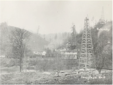
A circa 1900 image at Cornwallis during the height of the oil boom. Wells were drilled at any location that oil could be extracted which accounts for the derricks on the hillsides as well. The railcars are near the B&O and Harrisville Southern junction. Image John G. King collection/also listed West Virginia Regional History Archives
The quiet village that is now Cornwallis still reveals telltale hints of a booming past if one looks close for the clues. Random oil wells operate in dispersion as a subtle reminder of a booming industry a century ago. Near the mouth of Bonds Creek can be seen traces of a long ago abandoned railroad that ran from this location to the seat of Ritchie County, the Harrisville Southern. And of course bisecting the town is the roadbed of another abandoned railroad, the B&O Parkersburg Branch, former component of a mainline from Cumberland to St. Louis.
If the sightseers that trek the North Bend Rail Trail today could enter a time machine and adjust the setting for one hundred years ago, the viewfinder would fill with a booming oil industry. They would also step away from the trail since it has morphed into an active B&O Railroad busy with mainline trains and connecting movements with the Harrisville Southern. People would be more prevalent as the population was substantially greater due to more residents and workers.
A wide angle view of Cornwallis during its oil boom glory of the early 1900s. This photo was evidently used to identify oil wells as they are designated with letters of the alphabet. A good look at the layout of the town with the railroad and the North Fork Hughes River. The letter "U" at far left is also the hill pierced by Tunnel #14. Image West Virginia and Regional History
Cornwallis was an active B&O block station (call letters CO) until it was displaced by CTC in 1951. The passing siding remained in use after the World War II years but was gone by 1970. During the steam era, the location was equipped with two water tanks as it was at an interval along the route that refills were necessary. B&O listed one active on line shipper as of 1948---the Henaghan & Hanlon Oil Company. There was apparently enough oil related activity for this company to remain in business at this comparatively late date.
|
This circa 1920 winter image of Cornwallis gives testament to its importance during the B&O steam era. The two water towers dominate the scene as other lineside structures loom in the background. An interesting scene that begs to be replicated on a model railroad. Image Dan Robie/John G.King collection
|
This image is from the same era as the one at left but includes the Cornwallis depot. Taken during the heyday of the oil boom during which Cornwallis was a thriving community. Note the crossover track connecting the mainline and the passing siding. Image West Virginia and Regional History
|
Incorporated in 1907, the Harrisville Southern was another short line railroad within the confines of Ritchie County that connected with the B&O. From its junction with the big road at Cornwallis, the H&S followed the course of the North Fork Hughes River nine miles to the town of its namesake, Harrisville. Of the short line roads that served the region, the Harrisville Southern functioned much like a larger road. It operated two daily runs timed to connect with B&O passenger trains at Cornwallis and during its prime, funneled passengers to and from the station at Cornwallis. The line prospered hauling freight in accordance with the oil boom years and to a thriving business at Harrisville.
Unfortunately, progress in road development ultimately doomed this small railroad. Just as with the other small lines that connected with B&O serving rural regions, trucks and automobiles sapped the lifeblood of its existence until none remained. By the mid 1920s, the fate of the Harrisville Southern was sealed and the line abandoned. Shortly thereafter, the rails were pulled and the remaining equipment sold.
|
A view of the horrific May 31, 1956 derailment at the Bonds Creek bridge. Trailing locomotive E6B 61X is toppled on its back straddling the creek bank. The headend car of the National Limited is directly behind it on its side. Image courtesy Ritchie County Historical Society
|
This distant view shows the workers and investigators on site. The locomotives pictured are power for the relief train dispatched to the scene for the cleanup. Image courtesy Ritchie County Historical Society.
|
The stillness of the Cornwallis night was shattered at 2:22 AM on May 31, 1956 with a catastrophic accident involving Train #1, the westbound National Limited. Unbeknownst to the locomotive crew as the train was passing through Tunnel 13, a massive slide from above the west portal of the tunnel had inundated the track at the approach to the Bonds Creek bridge with rock and fill. As the train emerged from the tunnel, the engineer had no chance to brake the train as it struck the slide at 45 MPH. The lead unit, E6A #52, broke in half with the cab section landing in Bonds Creek and the rear half coming to rest on the creek bank. Trailing unit #61X, an E6B, was severely damaged as it came to rest on the east bank of the creek. The first three cars in the trainset were heavily damaged with the remaining derailed cars suffering moderate damage. Exceeding the train damage is the tragic toll this accident took on crew and passengers. Sadly, the engineer and fireman were killed and forty-five injuries of varying degree were sustained by passengers and railroad personnel.
ICC determined that the 615 ton rock slide had occurred shortly before the National Limited arrived at Cornwallis. An eastbound manifest had traversed the location an hour and a half earlier and passed without incident. B&O maintenance of way employees also cited no previous slippages at this location and in conclusion, the ICC attributed the tragic accident solely to the rock slide. The North Bend Rail Trail Foundation erected a plaque---purchased by the family of the engineer--- in remembrance of this accident. It is located on the west bank of Bonds Creek at the scene of the tragedy.
ICC determined that the 615 ton rock slide had occurred shortly before the National Limited arrived at Cornwallis. An eastbound manifest had traversed the location an hour and a half earlier and passed without incident. B&O maintenance of way employees also cited no previous slippages at this location and in conclusion, the ICC attributed the tragic accident solely to the rock slide. The North Bend Rail Trail Foundation erected a plaque---purchased by the family of the engineer--- in remembrance of this accident. It is located on the west bank of Bonds Creek at the scene of the tragedy.
|
The remains of a water pump house used by the railroad in the distant past. Image courtesy North Bend Rail Trail Foundation
The ghosts of Cornwallis. A gutted home sits adjacent to the right of way and a whistle post that no longer serves a purpose. Image courtesy North Bend Rail Trail Foundation
|
This unique perspective from the trailing locomotive captures the engineer in the lead unit and the track ahead. As the railroad is ripped up behind him, one can only wonder what his thoughts were. Image courtesy Alan Nichols 1988
|
Between Cornwallis and Ellenboro
Another excellent image of Parkersburg Branch removal from the collection of Alan Nichols. Moving eastbound by the deactivated color position light at Milepost 352.2 with the track ahead. To the right is what appears to be a remnant of the Cornwallis block station taken out service almost forty years earlier and at left the roadbed from the former passing siding. Soon there will be only roadbed where the mainline is. Image courtesy Alan Nichols 1988
The region east of Cornwallis was a remote stretch of railroad on the Parkersburg Branch. Just as to the west, the line bypassed sharp creek bends and followed the valleys as possible. This facilitated the construction of four more tunnels east of Cornwallis none of which were exceptionally long with Tunnel 12 the longest at 577 feet. Tunnel 13 will forever be associated with the 1956 National Limited derailment but in terms of construction, Tunnel 10 is the most unique not only in this sector but on the entirety of the Parkersburg Branch. This bore is cut through solid rock and was never timber lined or later brick arched as were the other tunnels. Originally named as Patterson's Tunnel, it received the second name of Dick Bias Tunnel in honor of the founder of the North Bend Rail Trail Foundation. The remaining bore in this region was Tunnel 11 which was daylighted in 1963.
This 1996 Google Earth view offers a glimpse of the remote territory between Cornwallis and Ellenboro. Three of the four tunnels are extant with only Tunnel 11 having been daylighted during the 1963 clearance project. East of Tunnel 12, the railroad left Bonds Creek and continued east along Hushers Run.
|
Train #32, the eastbound National, enters the west portal of Tunnel #13 in this circa mid 1960s scene. The GP9 paired with the E unit was common with this train. Image courtesy Bill Gordon
The project underway at Tunnel 12 west portal. Outcropping above has been opened but ceiling not raised to increase clearance yet. The original portal is still in place at this time. Image courtesy North Bend Rail Trail Foundation
|
The west portal of Tunnel 13 at the east end of Cornwallis. This tranquil scene of the North Bend Rail Trail is a marked contrast to the tragic National Limited accident that occurred at this exact location over half a century ago. Image courtesy North Bend Rail Trail Foundation
Only two remaining tunnels on the Parkersburg Branch are not arched through their entirety---the natural Number 10 and pictured here, the now squared Tunnel 12. Project work in progress and the new façade is under construction. Image courtesy North Bend Rail Trail Foundation
|
Not surprisingly, B&O listed no active online shippers in this region as of 1948. If any did ever exist, they probably disappeared very early in the history of the Parkersburg Branch. The sheer isolation of this stretch of railroad in addition to few roads was prohibitive to any business of consequence locating here. A most lonely stretch of railroad indeed.
|
Frigid image of the east portal of Tunnel 12. Note the lining added to the portal roof during the 1963 project work. Image courtesy North Bend Rail Trail Foundation
|
Unless one is keen spotting clues, it would be easy to pass this spot without realizing a tunnel was once located here. Tunnel #11, also named Teneriffe, bored through a ridge seam that spanned the right of way. Daylighted in 1963, it held the distinction as the shortest of the original twenty-three Parkersburg Branch tunnels. Image courtesy North Bend Rail Trail Foundation
A very rare image of a B&O steam era train on the Parkersburg Branch circa 1920s. This eastbound train is led by what appears to be an E-27 2-8-0 Consolidation although I am not certain of the sub class. This is an exceptional photo on several counts. An action scene at a remote location with the photographer framing the train on the Hushers Creek bridge about to enter the west portal of Tunnel 10. The essence of the Parkersburg Branch with its tunnels and bridges captured in a single scene. Image courtesy of Ritchie County Historical Society.
|
East of Tunnel 10, the railroad continued along the Hushers Creek drainage for the next few miles where upon it entered the town of Ellenboro. B&O listed no online shippers between these points at least from the mid- 20th century until the line abandonment.
|
A 1988 view looking eastbound from inside Tunnel 10. Railroad track passed through this tunnel for 131 years but its days were numbered when this image was made. Alan Nichols knew that track removal was in progress west of here so he moved east of the work to capture images such as this before it was taken up. Image courtesy Alan Nichols 1988.
|
The Philadelphia Trailer Train exits the east portal of Tunnel 10 in this 1977 image. A ubiquitous GP40-2, the #4129, leads this high priority train east between Cornwallis and Ellenboro. Image courtesy Dave Dupler/Art Markley collection
|
Ellenboro is a transition on the eastward trek to Clarksburg. From this point onward, the railroad faithfully followed creek drainages as it passed from one community to the next. The remaining tunnels along the route were further spaced in contrast to the high concentration that existed between Cairo and Ellenboro. US Route 50 becomes a familiar parallel following the path of the railroad as it touched the towns along the route. The original Route 50 was a virtual reflection of the railroad matching its course continuously but for few exceptions. When the highway was upgraded to four lanes in the early 1970s as West Virginia Corridor D, it bypassed the town centers thereby not adhering to the railroad as before.
Ellenboro
This topo map focuses on the region to the east and west of the Ellenboro/Lamberton area. Tunnels serve as bookends with Number 10 at the west extremity and Tunnel 9 to the east. The railroad continued to parallel Hushers Run through this sector.
Ellenboro, incorporated in 1903, indirectly owes the origin of its name to the building of the railroad during the 1850s. The name was chosen in honor of Ellen Mariah Williamson, eldest daughter of the family that granted the railroad a right of way through the area.
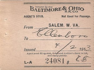
An agent ticket stub dated 1913 for a trip from Salem to Ellenboro. Looks like the agent decided upon a fare of .65 instead of .63. A good deal either way. Image courtesy North Bend Rail Trail Foundation
All of the passing sidings on the Parkersburg Branch were utilized for the facilitation of meets. During the steam era, the sidings at Cornwallis and Rock Run were certainly prominent as water stations. But in terms of a sheer strategic location, the siding at Ellenboro may have proved the most viable. During the World War II years when extra movements competed with scheduled freights and passenger trains, the railroad was especially busy at night. This is also when the premier passenger trains, the National Limited and Diplomat, also traversed the Branch and without delay. A dispatcher or block operator that held these trains better had good reason to do so.
Eastbound freight trains were typically heavy since higher proportion of loads moved this direction. Trains running east from Parkersburg ran slower than their westbound counterparts due to grades and curvature. The gradients on the Branch were short but steep enough to affect the speeds of the trains and dispatchers in the pre CTC era maintained vigil with block operators as to their progress. Enter the Ellenboro siding. As scheduling and traffic patterns often dictated, it was this geographical location along the Branch that dispatchers often arranged the meet of an eastbound freight to clear in order that the National Limited and Diplomat could pass unimpeded on the nocturnal railroad.
Eastbound freight trains were typically heavy since higher proportion of loads moved this direction. Trains running east from Parkersburg ran slower than their westbound counterparts due to grades and curvature. The gradients on the Branch were short but steep enough to affect the speeds of the trains and dispatchers in the pre CTC era maintained vigil with block operators as to their progress. Enter the Ellenboro siding. As scheduling and traffic patterns often dictated, it was this geographical location along the Branch that dispatchers often arranged the meet of an eastbound freight to clear in order that the National Limited and Diplomat could pass unimpeded on the nocturnal railroad.
An eastbound view circa 1900 of the Ellenboro depots---the freight house on the left and the passenger station at right. Not sure what the primary subject was in this image---the structures or the men. Either way, history is grateful for the photograph. Image courtesy of Ritchie County Historical Society
The B&O depot at Ellenboro remained an active location until after the World War II years. As passenger trains declined and their numbers abolished, it eventually lost its status as a scheduled stop. It did, however, remain a flag stop for the West Virginian through the late 1950s. B&O maintained a block station here (call letters BU) until it was eliminated by the onset of CTC operation in 1951. I could find no actual listing for Lamberton on a timetable as a scheduled or listed flag stop. If it ever was, it was eliminated at least by the early 1900s. Since it was adjacent to the town of Ellenboro, the facilities there likely sufficed for both.
As of 1948, B&O listed three active on line shippers in the Ellenboro and Lamberton region--McDougall & Cunningham and the West Virginia Farm Bureau Service. The Hope Construction and Oil Company was located just to the east between Lamberton and Tunnel #9.
|
This 1988 scene at Ellenboro is a harbinger of the end. An empty rail rack train will soon be used to haul the rail pulled up from the track removal. At this time, track had already been removed from Walker through the area between Cornwallis and Ellenboro. The mainline and passing track in this scene will soon be history. Dan Robie/John G. King collection
|
The same location approximately a month later. All of the removed rail, ties, and ballast will be salvaged for use elsewhere. In recent years, the Parkersburg Branch had undergone extensive maintenance and was in excellent condition. Ironically, CSX was removing one of its better sections of railroad during this era. Dan Robie/ John G. King collection
|
Moving east from Lamberton, the railroad continued to parallel Hushers Run until reaching the headwater at Tunnel 9. During the 1963 clearance project, B&O opted to daylight this 855 foot bore, Butchers Tunnel, the second longest tunnel on the Parkersburg Branch to meet this fate. Prior to the tunnel removal, US Route 50 circumvented the hill that contained Tunnel 9 by running a semi-circle to the north. After the hill and tunnel were removed, a new US Route 50 bridge was built directly across the cut which eliminated the circuitous bypass.
Although not directly railroad related, this image is also reflective of a bygone era. The Washington Inn at Lamberton was representative of many such businesses that once populated the US Route highway system. The Interstate highway system and other four lane bypasses doomed these businesses that were mainstays in local economies and often charming. Many that do remain in existence have seriously declined or are in disrepair. Image courtesy North Bend Rail Trail Foundation.
|
A 1921 photo taken at Lamberton looking east that captures the railroad and highway construction. Early paving of US Route 50 with concrete when road improvement was in its infancy. The road at this location was ultimately eliminated by future realignment. Image West Virginia and Regional History
|
An opposite view of image at left looking west. The girder plate bridge on the railroad crosses Hushers Run and the siding may be the Hope Construction and Oil Company. Butchers Tunnel--Tunnel #9---is about a mile east of this location. Image West Virginia and Regional History
|
|
This 1996 Google image reveals work done 33 years earlier. A minor highway improvement was a direct result of the 1963 tunnel clearance work. Once Tunnel 9 was daylighted, a curve on US Route 50 that circumvented the former hill and tunnel was bypassed. The road was straightened and a bridge was constructed over the cut.
|
Present day right of way view of where Tunnel 9 once stood east of Ellenboro. Daylighted as a cut during the 1963 clearance project. Image courtesy North Bend Rail Trail Foundation.
|
End of Part I-Parkersburg to Clarksburg-Waist of the B&O Main
All credits will be listed at conclusion of Part II
Part II-Parkersburg to Clarksburg-Waist of the B&O Main will resume with a section devoted to the Parkersburg Branch tunnels and then continue eastward from Pennsboro. Click HERE to continue.
All credits will be listed at conclusion of Part II
Part II-Parkersburg to Clarksburg-Waist of the B&O Main will resume with a section devoted to the Parkersburg Branch tunnels and then continue eastward from Pennsboro. Click HERE to continue.
