Ohio River Railroad part ii-Parkersburg to Kenova
Preface
It was on a fishing trip with my father some forty plus years ago that we parked near the railroad at Millwood, WV. A glorious summer morning enhanced more so by the passage of time and the memory of a man who was so very dear in my young life. As we loaded up our tackle and supplies for the walk over the bank where Little Mill Creek meets the Ohio River, the horn of a northbound (railroad east) train blew signaling its approach at a crossing about a quarter of a mile away. Knowing that his son would want to see this train, my dad, a virtue of patience, stood with me to watch it pass. The years have dimmed the memory of the locomotives except that they were in Chessie System colors and behind them was a maintenance of way train probably headed for Parkersburg. What followed has remained with me since and influenced my interest as it is today. This passing work train evoked memories in my dad from his earlier years. He said to me, “Dan, you know that your Grandad would talk to me about when this railroad was built. He recalled the workers constructing the right of way and laying the rail and what a difficult job it was”.
Later that afternoon after it became too hot to fish, we moved down the river to Letart and pulled off the road there. Back in that era, there was a road side dairy shop located along then US Route 33 that served those summertime treats, ice cream cones and milk shakes. Again, the railroad was nearby and we walked over to it as my dad wished to share another memory. “It was here that I stepped off the train in December 1945 on the return from the war in the Pacific. Your Grandma and Grandad Robie had moved from Evans to Letart while I was overseas and remember them standing here to welcome me home”. Visits to Letart were always poignant for Dad. This small community---a mere dot on a map----was endearing to him. It was the first place he could call home after fulfilling duty to his country in a global war and to renew life.

That day long ago along the Ohio River has remained etched in my mind. Prior to it, my interest in trains was only to watch and model them. From that time forward, I yearned to learn about the history. The Ohio River Railroad, the B&O----how it related to family--- and more. Memories my parents could share ranging from my grandparents lives through their own. Someday, I thought, it would be great to share their experiences along with my own as time marched forward. And although I never wrote that book of which I so once emphatically dreamed, the internet has become the canvas to paint a portrait to share for all who embody a similar spirit. Two other such accounts were published previously---“B&O Ripley Branch---Millwood to Ripley” and “RS&G—B&O Ravenswood to Spencer Branch”. This addition of the Ohio River Railroad as to include B&O to present day CSX completes the “family” trilogy.
Parkersburg
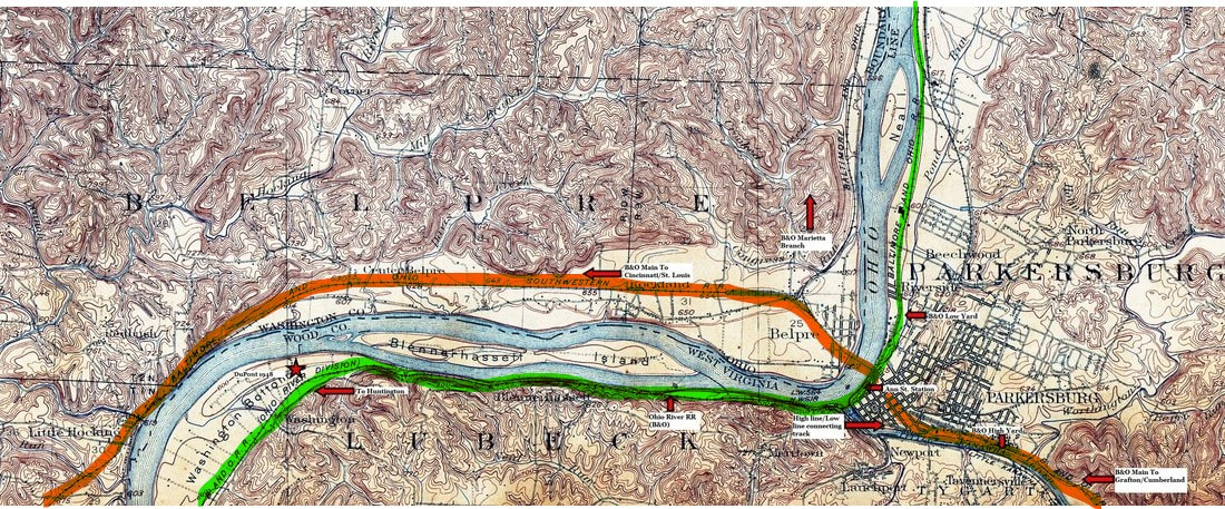
The major B&O Railroad hub of Parkersburg as it was in 1902. This crossroads location is where the Ohio River Railroad (green) maintained its major servicing facilities as well as sharing a connection with the B&O Cumberland to St. Louis main line (orange). The region of the map extends to Washington Bottom to the west.
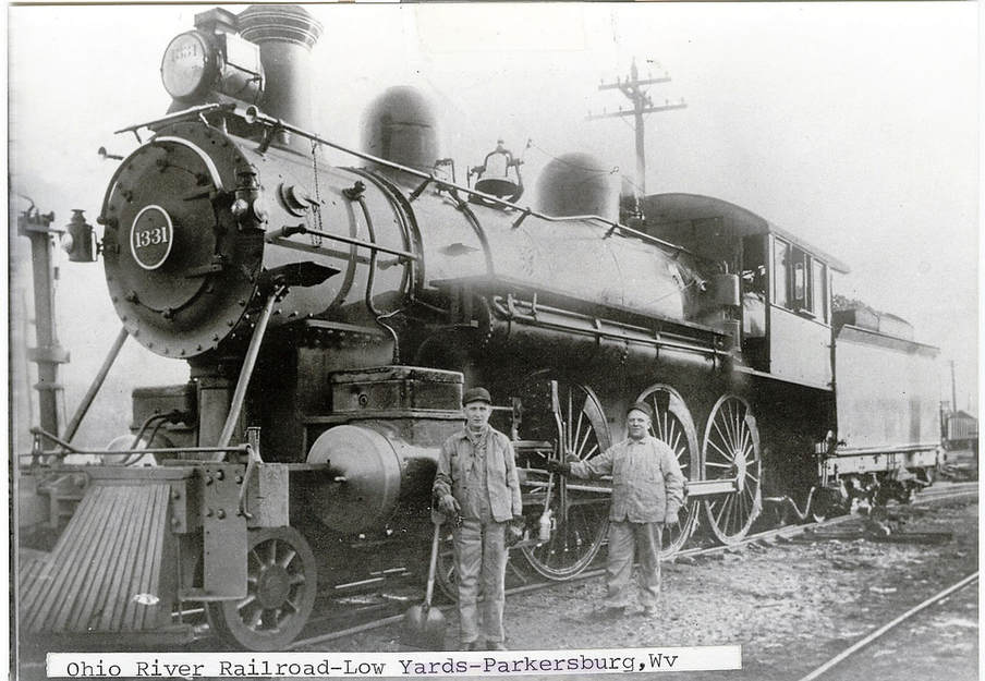
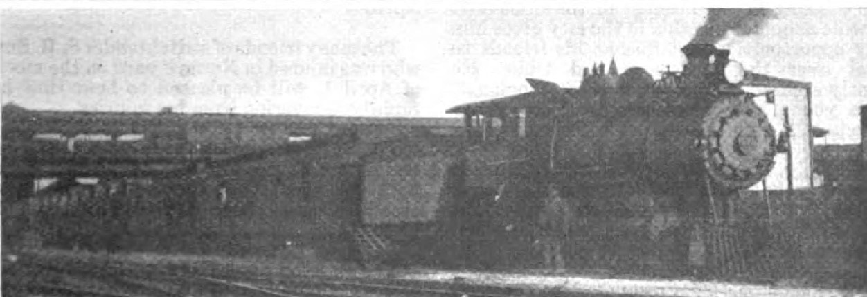
The engineer and fireman pose with this high driver beauty at Parkersburg circa 1915. A Class B-17 4-6-0 built by Baldwin in 1901, it was later reclassified B17a and remained in service until the 1930s. Image John G. King/Dan Robie collection
When the proprietors of the Ohio River Railroad embarked on the vision of completing a line connecting Parkersburg and Wheeling, they faced a similar situation at Parkersburg to what was encountered at Benwood and Wheeling—an already established railroad in place. Of course, the builders were cognizant of this fact and that was a critical motive in constructing the route. The Ohio River Railroad would serve as a connecting line between the two points while providing passenger and freight service at the towns between Parkersburg and Wheeling. Just as at Wheeling, the B&O Railroad preceded the Ohio River Railroad at Parkersburg (1857) and had already expanded westward towards Cincinnati and St. Louis when track was first laid along the Ohio River there in 1884. Ironically, the B&O continued looking westward and hence, did not build along the banks of the Ohio either upstream or downstream. Into this void stepped the Ohio River Railroad. After achieving its foremost objective of connecting Parkersburg and Wheeling, it turned it focus south (rail west) from the Little Kanawha River at Parkersburg with the intention of reaching another Ohio River port, the city of Huntington.
|
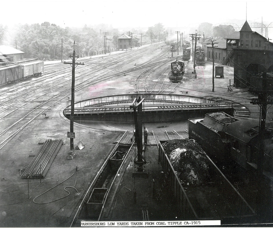
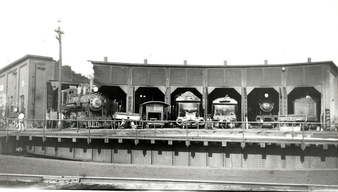
A westbound view through the Low Yard circa 1915. Taken from the engine house, an excellent view of the turntable, shop facilities, and track layout. MS Tower is in the distance at left. Image John G. King/Dan Robie collection
|
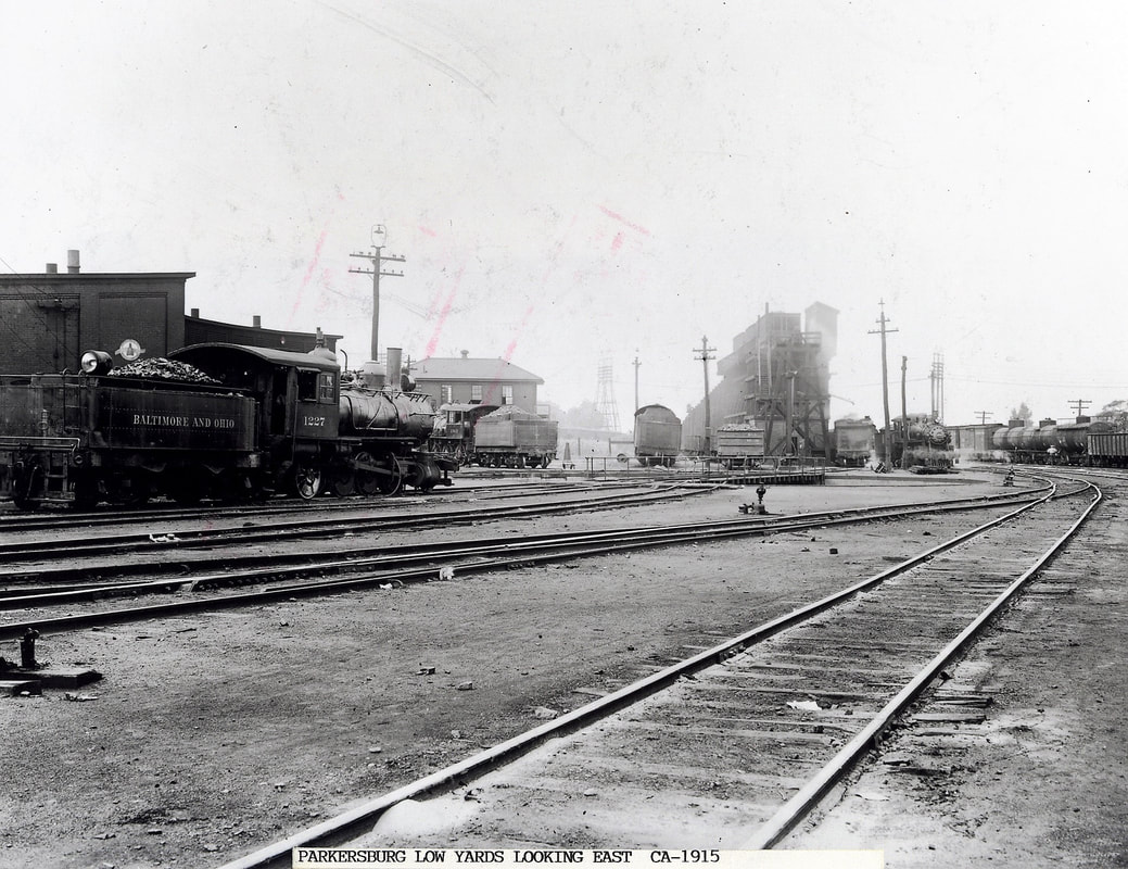
An opposite view looking east through the Low Yard circa 1915. Smaller steam power was the norm for this line during the early years of the 20th century due primarily to weight restrictions. Image John G. King/Dan Robie collection
|
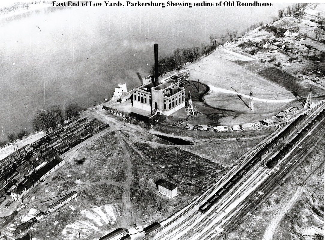
A 1960s aerial view of the east end of the Parkersburg Low Yard. By this date, the engine house had been demolished and the imprint of the radial tracks remains visible. The building at center is the Monongahela Power Company power house. Image John G. King/Dan Robie collection.
Parkersburg became the primary facility for the Ohio River Railroad with regards to locomotive servicing and assignments. A yard turntable, engine house, and shops were constructed at a location called Riverside along the Ohio River at the east end of town. Once the railroad expanded west to Huntington and Kenova by the end of the 1880s, Parkersburg was soon the geographical center of the railroad ideally placing the servicing facilities at the midway point. In 1948, B&O listed the yard as still a site for a track scale, water, and the turntable. Two towers were situated in the yard east to west, MS and SX, respectively. A connection also existed for the 5th Street coach yard near the Ann Street station.
By the turn of the century, industry began location in this bottom land region alongside the river. As with virtually every town located on the railroad, Parkersburg was not exempt from the fury of the Ohio River. The Riverside shops and the Low Yard, as it would eventually be known, were plagued by high water. Major flooding, as which occurred in years 1913 and 1937, was paralyzing and shut operations down.
By the turn of the century, industry began location in this bottom land region alongside the river. As with virtually every town located on the railroad, Parkersburg was not exempt from the fury of the Ohio River. The Riverside shops and the Low Yard, as it would eventually be known, were plagued by high water. Major flooding, as which occurred in years 1913 and 1937, was paralyzing and shut operations down.
|
A look at the engine house from across the turntable in another circa 1915 view. The camera is truly a marvelous invention as it is the closest entity to a time machine we have. Image John G. King/Dan Robie collection
|
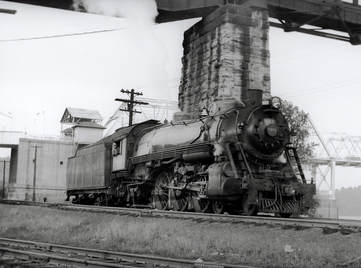
P-1 Pacific # 5057 waits in the Low Yard beneath the B&O main line Ohio River bridge in 1951. At this date, heavier power could traverse the entire length of the Ohio River line. Image John G. King/Dan Robie collection
|
In 1901, Parkersburg emerged as a complete B&O city when the road took control of the Ohio River Railroad and operated it until acquiring ownership of the line in 1912. Yet for decades, operation of it and of the east/west main line through town remained under separate jurisdictions. After the 1901 take over, the Ohio River Railroad was christened the Ohio River Division until 1921 when it was absorbed into the Wheeling Division. This remained in effect for forty years until 1961, the Wheeling Division was incorporated into the Monongah Division. During the era as separate entities, there was active transfer of freight between the two lines and certainly connections for passenger trains on the two routes.
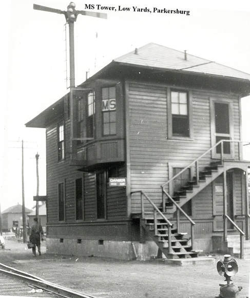
A guardian of the Parkersburg Low Yard, MS Tower as it appeared circa 1920. Another tower, SX, was located about a half mile west. John G. King/Dan Robie collection
A guardian of the Parkersburg Low Yard, MS Tower as it appeared circa 1920. Another tower, SX, was located about a half mile west. John G. King/Dan Robie collection
With a geographical east/west main line and another secondary north /south route, Parkersburg was a tremendous source of rail traffic and revenue for B&O at its industrial zenith. The storage capacity of the Low Yard during the late 1940s was approximately 23700 feet and it needed every foot of it. A 1948 list of shippers served from the Ohio River line in Parkersburg is an impressive one : Texas Oil Company, Burner Lumber Company, Knickerbocker Stamping Company, Hope Natural Gas Company, Universal Glass Products Company Number #1 and #2 plants, L.G Matheny Company, Texas Company, Beechwood Chemical Company, Union Corrugated Company, Parkersburg Steel Company, Fallansher Steel Company, City of Parkersburg, Monongahela Power Company, Criss Concrete Company, Citizen Concrete Company, Kanawha Sand Company, Parkersburg Ice and Fuel Company, Imperial Ice Cream Company, International Harvester Company of America, Ross Cox Junk Company, and the Pennzoil Company. In addition, the Ohio River line served the following list of shippers in conjunction with the Parkersburg Branch (main line) at the Second Street spur: C. A Robrecht Company, Altman Feed Company, Dana Grocery Company, W. H. Smith Hardware, Crotty and Company, Gunther-Morris-Campbell Company, Parkersburg Junk Company, Mountain Iron& Supply Company, Citizens Coal and Concrete Company, Parkersburg Metal Company, and the Superior Coal Company.
|
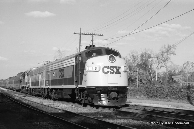
CSX F7A #118 in the Low Yard with an excursion train in October 1990. This was a Huntington to Parkersburg and return trip that my family and I had the privilege to ride. Photo Karl Underwood/Todd M. Atkinson collection
|
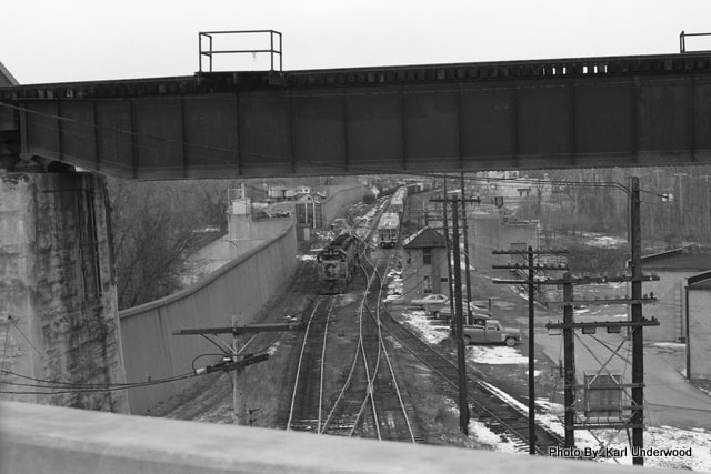
A view from the 5th Street Bridge looking into the Low Yard circa 1980. A westbound train is on the main at SX Tower. The B&O main line Ohio River bridge is in the foreground. Photo Karl Underwood/Todd M. Atkinson collection
|
|
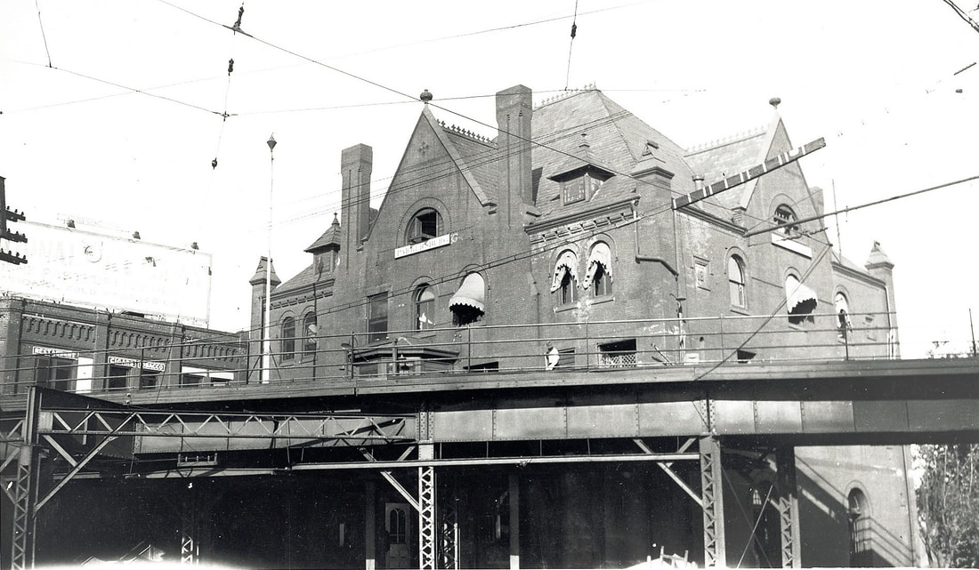
The Victorian Ann Street station from the west side (track side) during the 1920s. One of three regal stations to serve the Ohio River line during the passenger era, this structure survived until its date with the wrecking ball in 1959. Image John G. King/Dan Robie collection
|
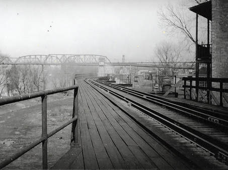
A view my mother saw many times during her trips to Parkersburg and Wheeling during the World War II years. Looking eastbound from the Ann Street elevated platform. Image John G.King/Dan Robie collection
|
The center of passenger train life on the Ohio River Railroad lasting until the demise of service was the Ann Street station. One of the elite passenger stations on the route, this multi-story Victorian brick building was a Parkersburg landmark for years. Its trackside access was on an elevated platform as a result of the east approach to the Little Kanawha River bridge. Passing below was the transfer track connecting the Ohio River line to the Parkersburg High Yard on the main line.
Ann Street officially ceased as a location to purchase tickets in 1954 but cash purchase for ridership continued a couple of more years. Space inside the building was also used for other railroad related purposes. In 1959, the noble old structure had outlived its useful service as passenger service had ceased but for one notable exception. B&O, in the midst of a financial crisis at this time, was eager to clear this structure from its tax ledger and the building was demolished. The financial situation of B&O at this time no doubt accounted for the quick demolition of other depots and stations on its system.
Ann Street officially ceased as a location to purchase tickets in 1954 but cash purchase for ridership continued a couple of more years. Space inside the building was also used for other railroad related purposes. In 1959, the noble old structure had outlived its useful service as passenger service had ceased but for one notable exception. B&O, in the midst of a financial crisis at this time, was eager to clear this structure from its tax ledger and the building was demolished. The financial situation of B&O at this time no doubt accounted for the quick demolition of other depots and stations on its system.
|
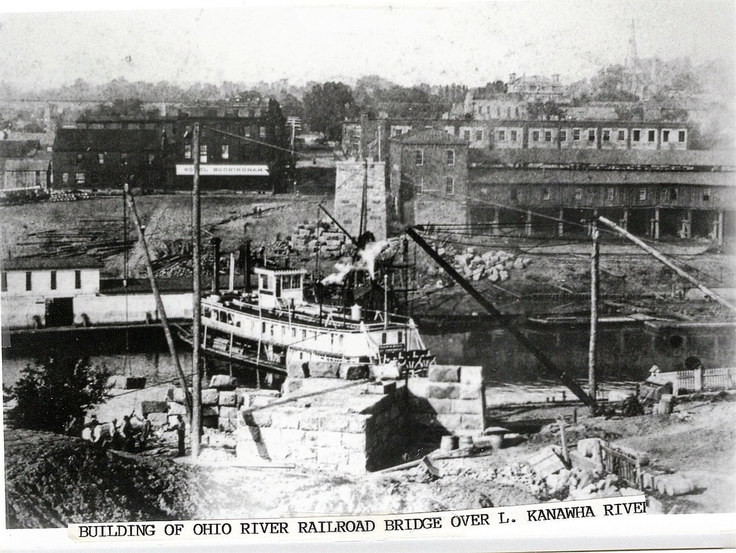
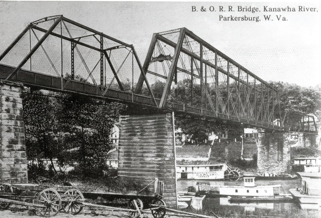
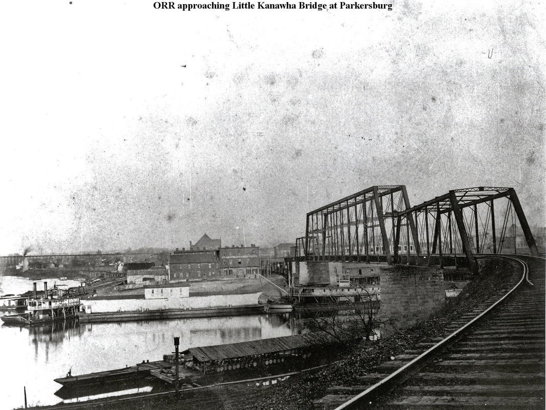
In its westward expansion to Huntington, the first obstacle facing the Ohio River Railroad was crossing the Little Kanawha River. This rare photo freezes in time the construction of piers for the bridge. Image John G. King/Dan Robie collection
|
Postcard image of the first truss bridge to span the Little Kanawha River. This view is probably circa 1905 after B&O had taken control of the line. Image John G. King/Dan Robie collection
|
Prior to 1947, Parkersburg was a switching point for power on westbound through traffic running the length of the Ohio River line. This was because of a weight restriction to the west at Point Pleasant due to the cantilever Kanawha River bridge. Heavier or double headed steam---such as 2-8-2 Mikados and 4-6-2 Pacifics--- often had to be swapped at Parkersburg for power such as 4-6-0 Ten-Wheelers. Accordingly, this also limited the amount of freight tonnage that could traverse the route between Parkersburg and Huntington.
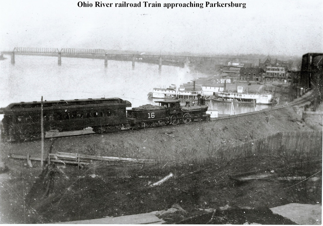
Two photos of the Ohio River Railroad from the Marrtown side of the Little Kanawha River bridge during the 1890s. At left, the Whipple truss bridge only a few years after its completion and at right, an eastbound ORR train approaches the bridge for a stop in Parkersburg. The river wharf and Ann Street station are visible in both views. Images John G. King/ Dan Robie collection
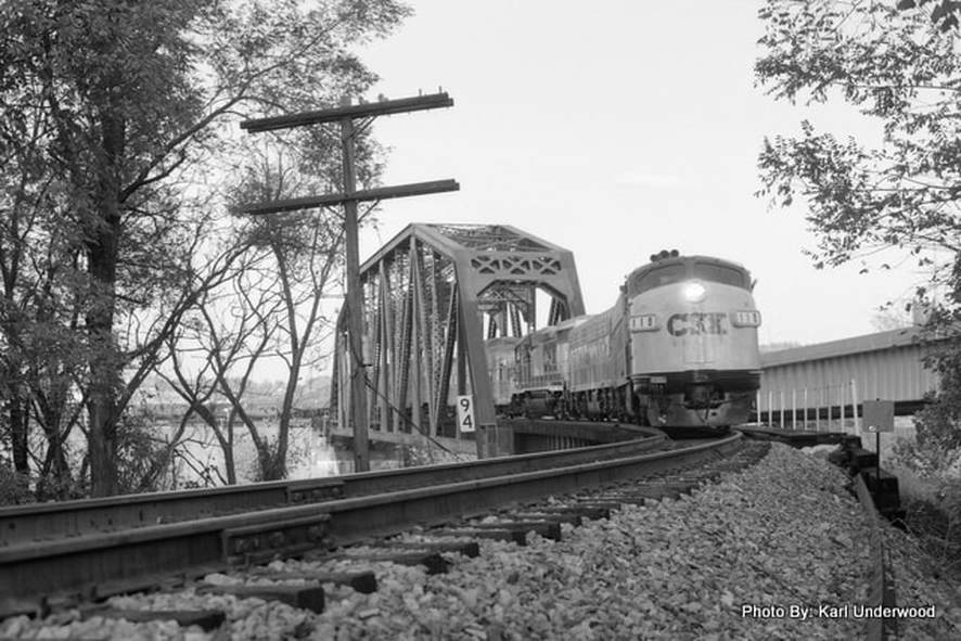
CSX F7A #118 leads the 1990 excursion train across the Little Kanawha River bridge. It is beginning the return trip to Huntington and would not arrive until late that evening. Photo Karl Underwood/Todd M. Atkinson collection
For almost exactly a century, the Ohio River line was the secondary line in Parkersburg. Though it did serve the Ohio valley with through trains between Huntington and Wheeling (and beyond), its primary purpose was to provide regional and connecting passenger service and to serve industries scattered along its course. In 1985, a reversal of roles occurred when the east/ west main line was downgraded between Cumberland and Cincinnati. By 1988, the Parkersburg Branch was severed between Parkersburg and Clarksburg and shortly thereafter, a segment of the Ohio Division between Belpre and Chillicothe followed suit. Once the dust settled, all that remained in the Parkersburg area of the former main was the High Yard and bridge access across the Ohio River to Belpre to serve industry there and the Marietta area. The Ohio River line now—by default—became the primary line through Parkersburg connecting the region to the remainder of the CSX network. (More can be read about the B&O main line on this site with "Parkersburg to Clarksburg--Waist of the B&O Main".
|
The Little Kanawha River bridge is the backdrop in this winter shot of Q316 arriving in Parkersburg. At right is the connecting transfer track between the High and Low Yards. Image Todd M. Atkinson 2014
|
Panorama of the rail axis of Parkersburg with two trains. A Relief, OH T824 coal train is crossing the former main line bridge while Q317 heads westbound on the Ohio River line. Image Todd M. Atkinson 2013
|
The Parkersburg of today is far removed from its glorious railroad past but remains a busy location for CSX. The Ohio River line is a crew change point on the route for scheduled trains Q316/Q317 and other extra movements. Local switching turns are based here to serve the industry along the river and the remaining piece of the truncated east/west main line in the High Yard and across the Ohio River in Belpre. The Low Yard continues to serve in its capacity as a staging and distribution point for area industry as well.
A wider view of the rail center of Parkersburg with both rivers high and muddy. Todd M. Atkinson again has captured two trains crossing both rivers simultaneously---another Relief coal train crossing the Ohio and a westbound empty ballast train spanning the Little Kanawha in this photo from 2007.
On the west bank at the mouth of the Little Kanawha River is the location of a small community known as Marrtown. In 1896, and independent railroad named the Little Kanawha Railroad constructed a line along the south bank of the river extending into Wirt County to the towns of Elizabeth and Palestine. A connection was established with the Ohio River Railroad at Marrtown and the road operated independently until it was taken over by B&O in 1920. Sections of the railroad were abandoned in 1933 and 1937, respectively and by the 1980s, only a few miles remained with active shippers. For year, a short runaround siding was located at this connection known as Ohio River Junction. By the end of the decade, CSX was ready to abandon the remaining segment but the line was saved operating again under independent ownership. This remaining section of railroad was reincarnated as the Little Kanawha Railroad. By means of its connection at Marrtown, the small railroad continues to generate traffic for the Ohio River Subdivision of CSX.
The "beautiful blue Ohio' my mother used to say. If she were living today, she would thoroughly enjoy this shot of empty gravel train T811 moving east at OR Junction in 2002 beside the beloved river of her youth. Image Todd M. Atkinson
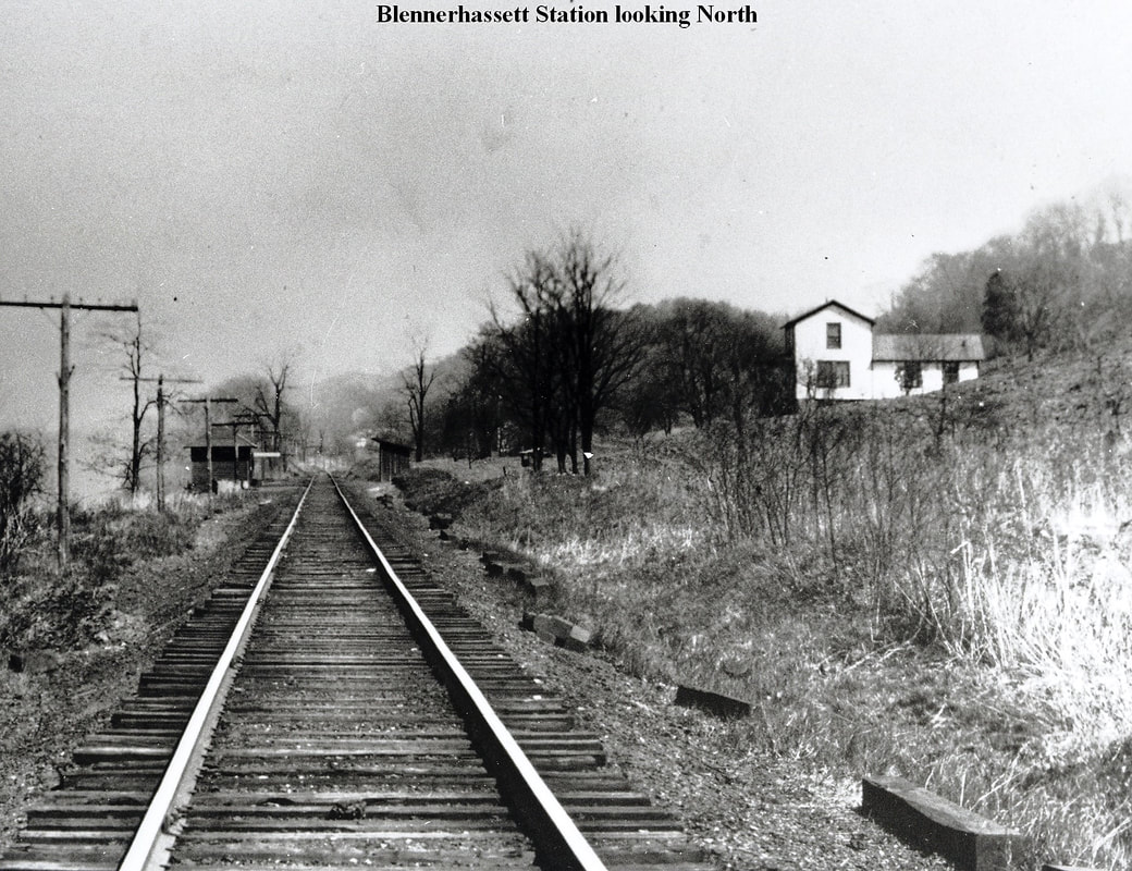
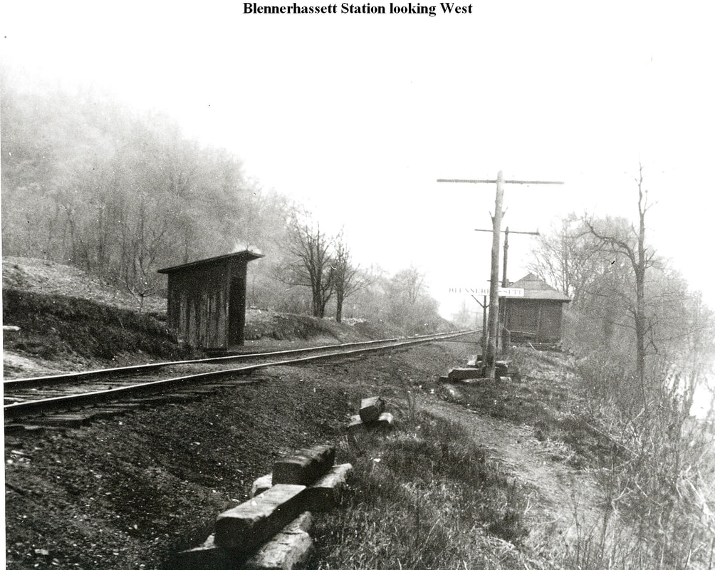
West of Parkersburg and nestled in the narrows between Parkersburg and Washington Bottom was the whistle stop of Blennerhassett. This location served the homes scattered about in the region during the Ohio River Railroad era extending into the B&O years. Named for the large and famous island in the Ohio River, the area overlooked the island that was the site of an infamous footnote in early American history. It was here that Harmon Blennerhassett, who purchased the east end of the island in 1798, allegedly conspired with Aaron Burr to commit treason against the United States.
Eastbound and westbound views of the tiny hamlet of Blennerhassett located in the narrows between Parkersburg and Washington. Named for the famous Ohio River island, these scenes capture the whistle stop as it appeared during the 1920s. Images John G. King/Dan Robie collection
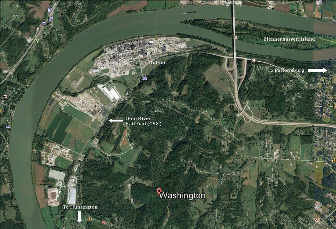
The Ohio River valley abounds with Colonial American history. Perhaps the most prominent figure during the time was none other than George Washington who surveyed much of the territory of western Virginia in the Ohio River region and obtained ownership of some of these lands. One such location was to the west of Parkersburg in a large river bottom that would bear his name. Years later, this fertile farmland would be subdivided into farms and became the domain of generations of families. In 1884, the iron horse first appeared as the Ohio River Railroad laid track through this bucolic area in its expansion westward. For more than fifty years, the setting remained the same until the end of World War II. George Washington today would recognize certain aspects of the bottomland he once owned but not the industrial development that transpired.
Google Earth view of Washington Bottom and the post war DuPont industrial development. In spite of 20th century development, the original agricultural and riverfront appeal of the area is easily discernible.
Representative of the industrial development along the B&O that occurred after World War II was the construction of the DuPont chemical plant at Washington Bottom in 1948. As one of the largest railroad shippers along the route---remaining so today with CSX---it was symbolic of the transition from an agricultural to industrial based economy and source of revenue for the railroad. This was particularly true of the region of the railroad west of Parkersburg. Also in 1948, B&O listed a 2000 foot passing siding at Washington that was primarily used for switching at the DuPont plant. Later industrial expansion at Washington Bottom would include industries such as Borg-Warner, DC Distribution, Nico, and L. B Foster.
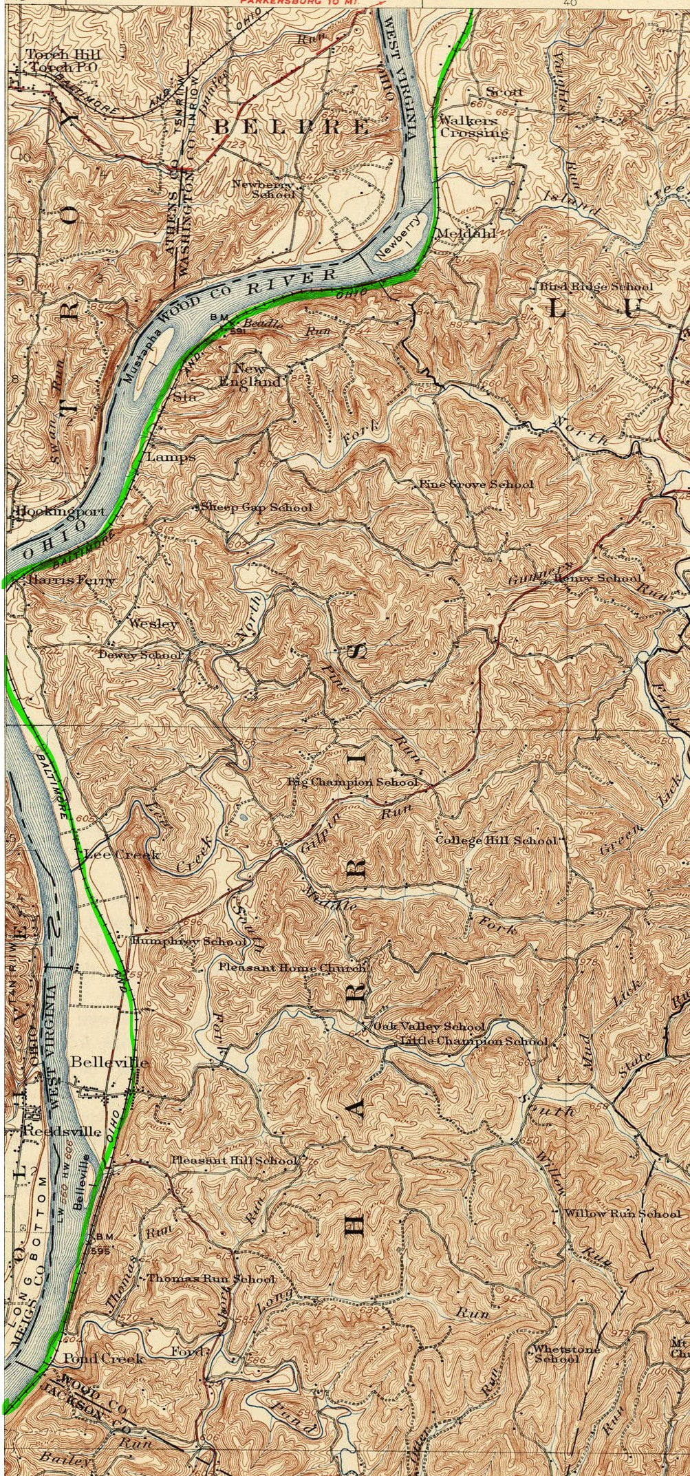
1924 topo map of the region extending from Washington Bottom through southern Wood County to the Jackson County line. This region is predominately farm land punctuated by small villages with Belleville the largest of note.
If one wished to see an example of how the railroad appeared during the Ohio River Railroad and B&O eras, the area between Washington and Ravenswood is one of two distinct regions where relatively little change has occurred. Defined by farm land and residential areas, the region remains untouched by modern development and thereby retains the original beauty of the Ohio River valley from years gone by. In fact, the only major development to occur here in the postwar years was the construction of the Belleville Locks and Dam that lasted from 1962 to 1968. Small villages dot the railroad right of way through here listed on railroad timetables as whistle stops from years gone by--names such as Meldahl, New England, Lamps, Harris Ferry, Lee Creek, Humphrey, and Belleville--the largest---and Pond Creek. During the early years of the railroad, agricultural products were shipped by rail but no commercial business of consequence existed. No railroad facilities existed in the region either excepting for a 2000 foot passing siding at Harris Ferry. That siding location remains today for CSX although its length has been increased.
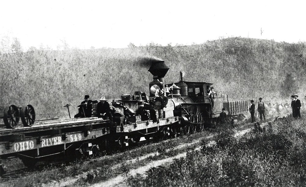
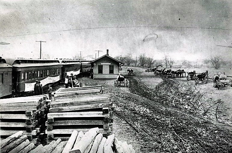
Westward construction of the Ohio River Railroad in 1884 possibly in the area of Harris Ferry. The ORRR Ten-Wheeler runs in reverse with its train as laborers lay the track ahead. Image John G. King/Dan Robie collection
|
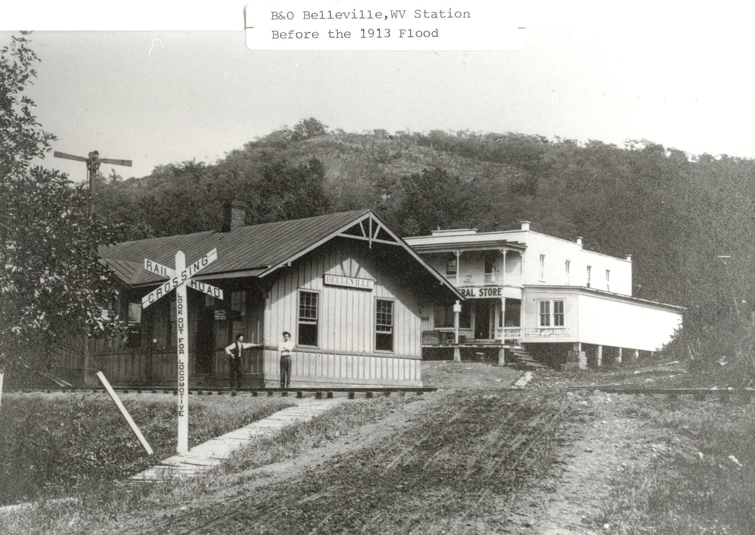
The first Belleville station as it appeared during the early 1900s. This structure was destroyed by the 1913 Ohio River flood. Image John G. King/Dan Robie collection
|
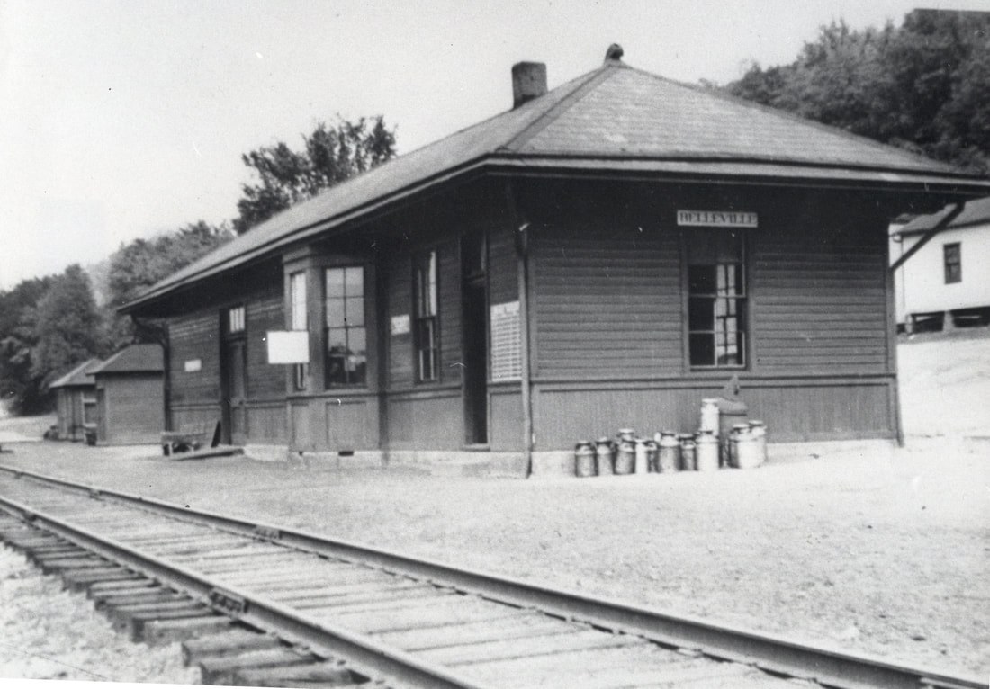
Replacement depot at Belleville in the 1930s. The architecture of this building is similar to numerous smaller B&O stations. Image John G. King/Dan Robie collection
|
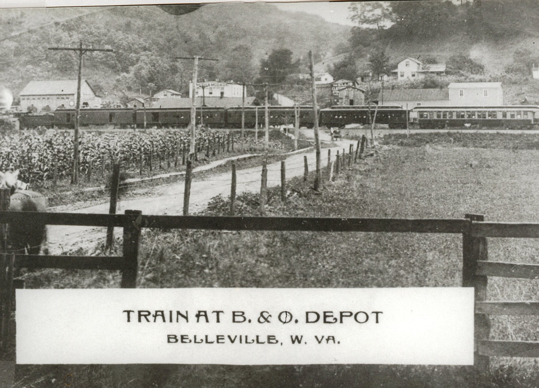
An eastbound train is paused at the Belleville depot circa early 1900s. This photo predates the 1913 flood as the original depot is visible behind the train. Image John G. King/Dan Robie collection
Jackson county
|
The region between Belleview and Ravenswood in northern Jackson County has remained relatively untouched by commercial developments throughout the years. Populated by tiny hamlets with an agricultural heritage, it retains the rural charm of bygone years in a beautiful river valley.
|
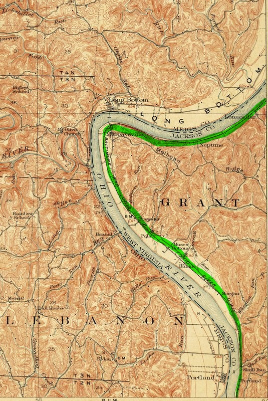
Moving west from Belleville, the railroad continues its trek through a long expanse of narrows until it is briefly interrupted by the small bottom area of Pond Creek. A small hamlet is located here that shares the same name and it is the last traversed in Wood County. From there, the railroad then enters Jackson County where it is also intertwined with family history. Small hamlets dot the railroad through here with names such as Lone Cedar, Neptune, Murraysville, Polk, and Portland among them. B&O trains would transport school children by rail in this region as late as the 1940s. Polk was also the location of an 1125 foot passing siding.
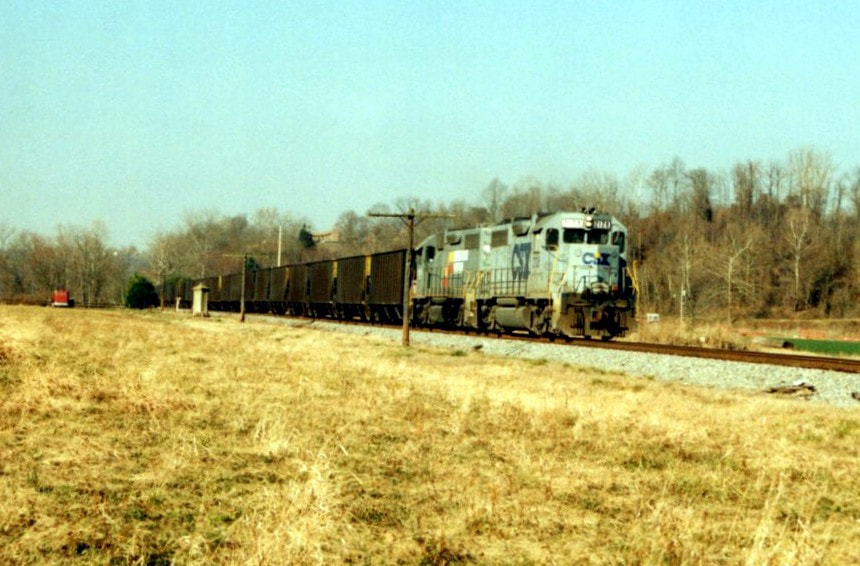
A train of coal empties moves westbound through Polk in December 1994 with CSX GP38 #2128 and a trailing former Seaboard EMD. Note the concrete telephone shack still in place. Image Todd M. Atkinson
|
Directly across the river on the Ohio side is where my maternal grandfather was born in 1871. As a teenager he could literally walk across the Ohio River in certain locations at low water levels as this time predated the lock and dam systems that would be constructed on the river. When water levels were normal, he would cross by boat. It was directly across from Long Bottom that he first witnessed the construction of the Ohio River Railroad near Ravenswood. From there, he traveled west along the river to the town of Millwood where he first met the lady that would become my maternal grandmother.
Ravenswood to Hartford
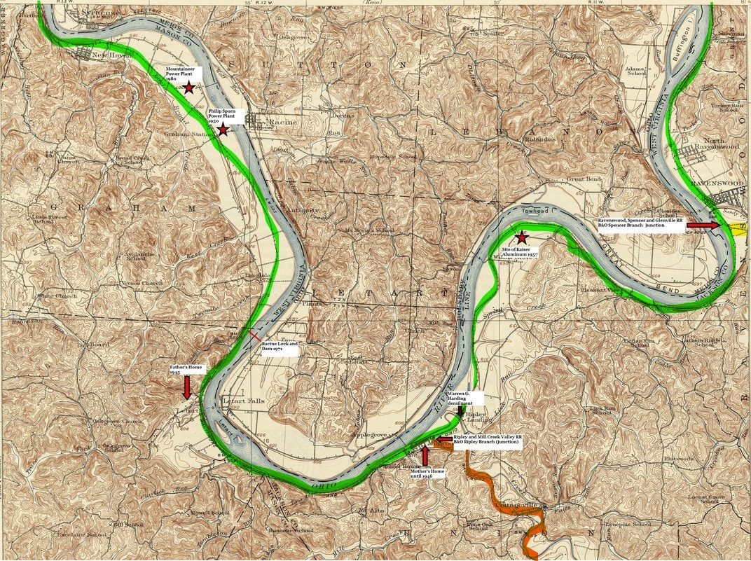
The most profound series of bends (Great Bend) of the Ohio River throughout its length is located in the territory bordered by Jackson and Mason Counties on the West Virginia side. Its snaking course increased the rail mileage between towns as it obviously is not direct. This region displayed on the map and west to Point Pleasant, on a personal front, is the crux of both family heritage and familiarity with both the river and railroad. The junctions of the branches to Spencer (yellow) and Ripley (orange) are noted.
In terms of land area, Jackson and Mason Counties are the two largest that border the Ohio River. With its series of bends bordering both, river shore line mileage is lengthy. As the railroad parallels the river accordingly, its mileage follows suit. Of the original 200 plus mile length of the Ohio River Railroad, more than 80 of those miles are in Jackson and Mason Counties.
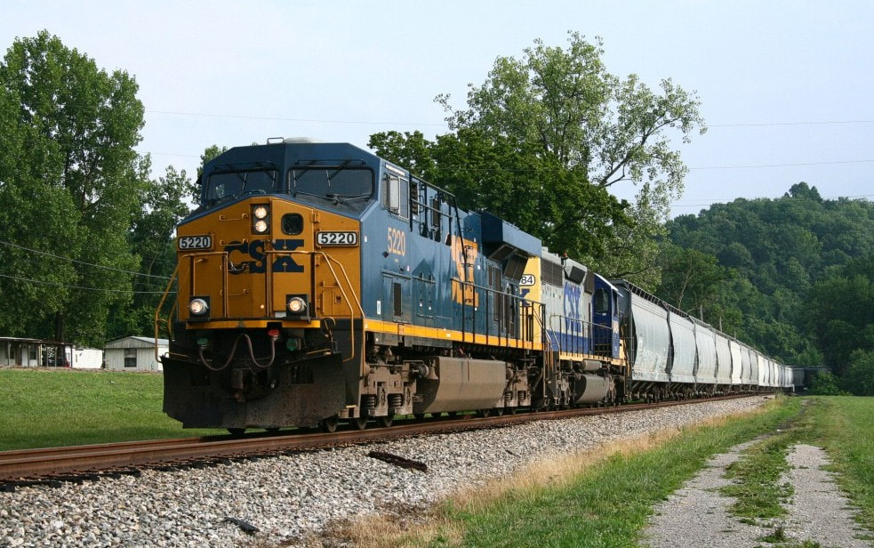
CSX Q316 moves through the community of Sherman en route to its next stop at Parkersburg. A then relatively new ES44DC #5220 and trailing SD40-2 lead the eastbound manifest. Image Matt Robie 2007
Ravenswood
George Washington left a large footprint---literally—in the upper Ohio River Valley. Another region he acquired land along the river is at present day Ravenswood and obtained another parcel of land to the west at Millwood. The town located at the confluence of Big Sandy Creek and the Ohio River would ultimately be planned with streets and lots laid out by the descendants of the "Father of Our Country" in 1835. Ravenswood was incorporated in 1852 in what was then the state of Virginia. As a river town, its commerce was significantly tied to that of river transportation and remained so for the next three decades. In 1886, the Ohio River Railroad continued to extend downstream (rail west) and laid track through Ravenswood transforming both commerce and travel.
|
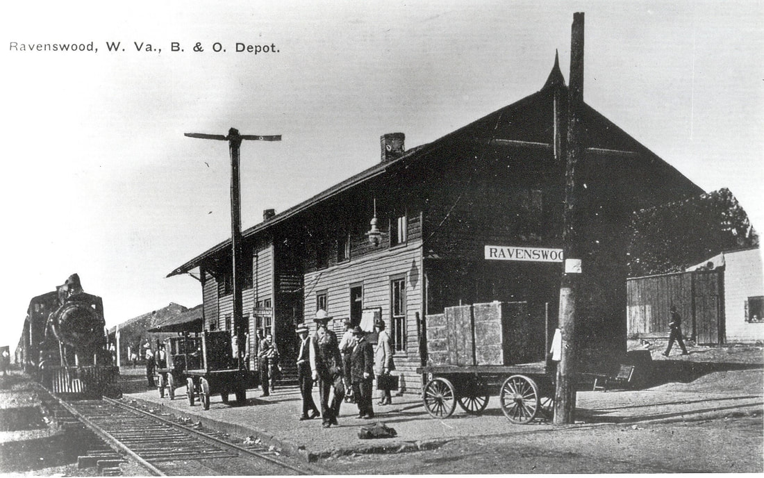
The Ravenswood passenger depot as it was circa 1915. A distinctly different type of architecture as compared to other wooden stations on the route. Image John G. King/Dan Robie collection
|
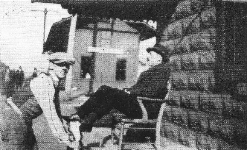
A day in the life 1922: Likely a rail passenger, this gentleman receives a shoe shine. Frozen in time for nearly a century, the young man forever smiles about this bit of business. Image courtesy Stephen Cooper
|
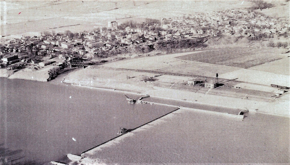
A remarkable aerial photograph of the Ravenswood riverfront as it appeared during the late 1920s. At this date, the town was compressed north of Big Sandy Creek. The B&O Railroad is clearly visible as is the truss bridge spanning Big Sandy Creek. RS&G Junction is just out of view to the right in this image. Before improved navigation on the Ohio River occurred during the 1930s, Ravenswood was the site of Lock and Dam 22. Image courtesy Jackson County Historical Society
Ravenswood increased in significance during 1892 with the completion of the Ravenswood, Spencer, and Glenville Railroad becoming the junction for it and the Ohio River Railroad. As a result, the town became a center of commerce in agriculture and livestock spurred by the RS&G reaching the city of Spencer in Roane County. A large stock yard was constructed at Spencer and Ravenswood was the connection for transport of cattle and other agricultural products from that railroad. In addition, agrarian commerce in the Ohio valley region of Ravenswood used the town as a local hub. The Ravenswood passenger station served patrons both on the Ohio River line and the RS&G. During the 1940s, B&O listed Ravenswood as the location for water, livestock servicing, and a wye (RS&G connection) Shippers included the Trenle Blake China Company, St. Dennis Milling Company, and the Ravenswood Grocery Company. A station agent was on duty here and the telegraph call letters for Ravenswood were RD.
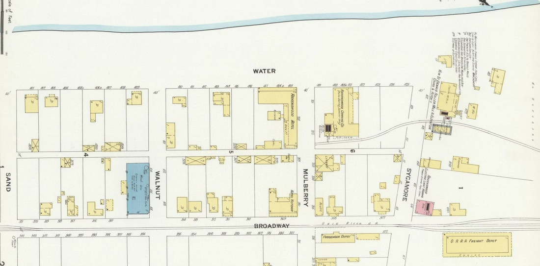
A 1909 depiction of the railroad district in the heart of Ravenswood. Two shippers were located here--St. Dennis Roller Mill and Elevator Company and the seasonal Ravenswood Canning Company. The freight and passenger depots are separated by Sycamore Street and note that the line is still the Ohio River Railroad at this date.
|
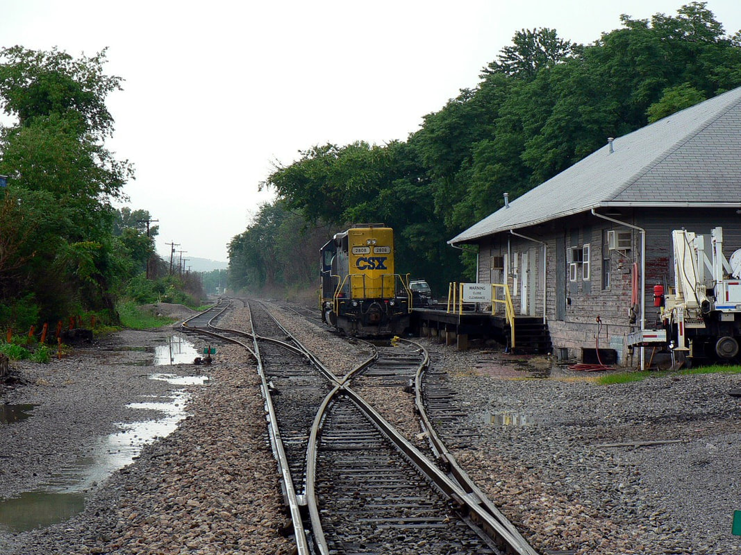
CSX GP38-2 #2808, the Ravenswood switcher, is tied down by the old freight station. A passing summer thunderstorm has created a late afternoon mist. Dan Robie 2007
|
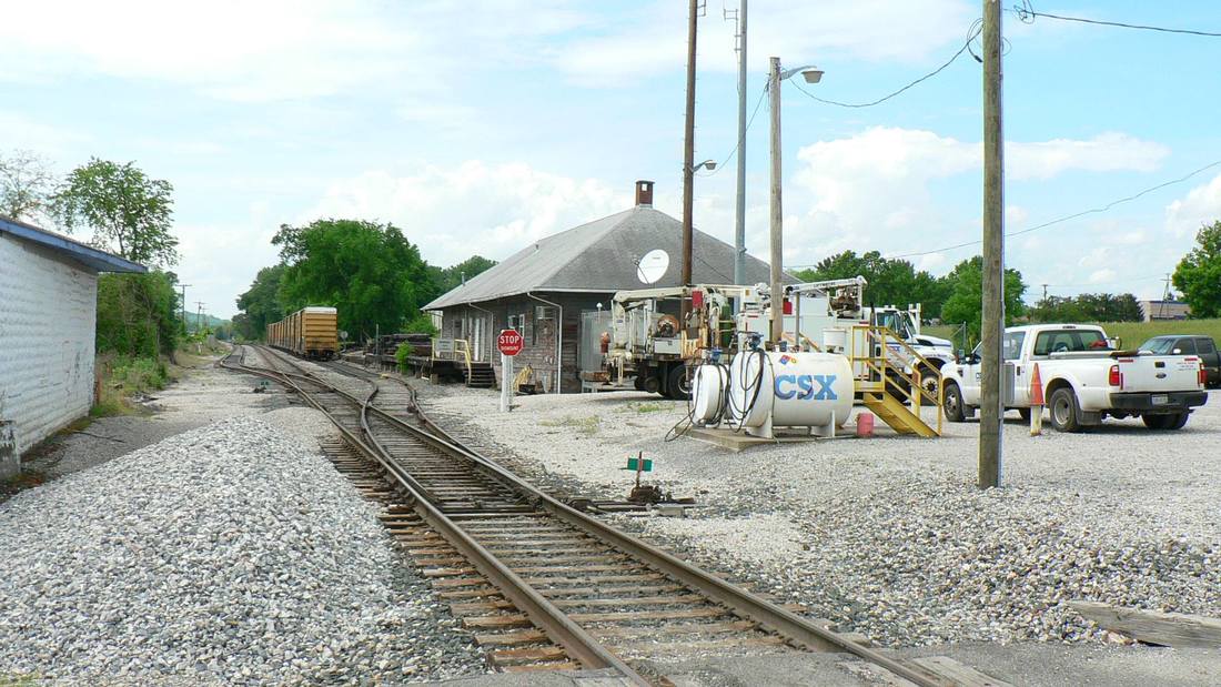
CSX uses the freight station for maintenance of way storage. A small terminal for local operations as well as a storage track. Dan Robie 2015
|
The greatest metamorphosis occurred at Ravenswood in 1958 with the opening of the Kaiser Aluminum plant west of town. Virtually overnight, the community transformed from an agricultural to an industrial based economy. The population increased and residential development expanded to the outlying areas as a result of this influx. B&O experienced a surge in carloads that was timely as agricultural based traffic was in decline. During the 1960s, B&O assigned a dedicated train to serve the plant known as the “Kaiser Jet” that would make connection with priority trains at Parkersburg. A local switcher was later assigned at Ravenswood to handle the traffic that continued into the CSX era. Unfortunately, the boom times were fading by the late 1980s due to a global glut of aluminum and widespread industrial decline. Kaiser Aluminum sold the plant in 1988 and though it now operates through multi ownerships, it is at a reduced capacity with the work force drastically reduced. CSX still serves the plant but a far cry from past levels.
The ever nomadic Richard J. Cook paused at Ravenswood to catch this Train #73 approaching RS&G Junction in 1951. This scene is dramatically different today as the highway and other structures have since been constructed here.
As Ravenswood was the closest town with a commercial district to Millwood, my mother’s family generally conducted business there. This usually meant a short train trip to Ravenswood and then return on the next westbound during the pre-World War II years. Family members—an uncle and cousins—worked at the Kaiser Aluminum plant during its lifetime.
|
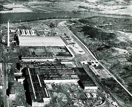
Massive Kaiser Aluminum plant west of Ravenswood shortly after its completion in 1958. This plant single handedly transformed the economy of Ravenswood from agrarian to industrial based. Image West Virginia and Regional History
|
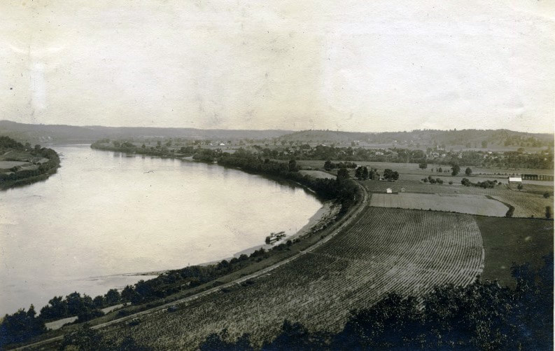
1930s view looking eastbound (north) along the Ohio River with the railroad visible along its bank. Location of this scene is between Ravenswood and Millwood. Image West Virginia and Regional History
|
Moving west from Ravenswood, the railroad continued through bottomland before entering narrows at Pleasant View until reaching the mouth of Mill Creek at a location known as Ripley Landing. This location derived its name as the river port for the county seat of Ripley inland from the river along the Mill Creek basin. Seldom ever referred by that name, it was generally considered a section of Millwood on the opposite bank of Mill Creek.
|
Westbound view of the deck bridge spanning Mill Creek at Millwood. This span was the site of at least two recorded derailments during the early 1900s. Dan Robie 2016
|
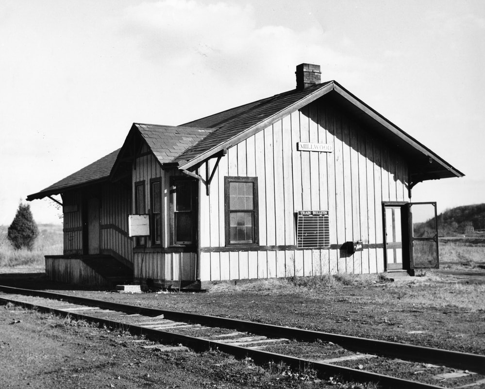
A forlorn looking Millwood depot in the late 1950s after passenger service ceased. My mother boarded and disembarked from numerous trains here during the World War II years. Image John P. Killoran/Bob Withers collection
|
The railroad bridge spanning Mill Creek has an infamous early history as there are at least two recorded derailments that occurred here. In 1912, a train of dignitaries was traveling eastbound to Parkersburg when the last car left the rails on the bridge but remained upright. The train continued onward with the car somehow tracking inside the rails and attached to the train. Once it arrived at Ravenswood, it was cutoff and eventually rerailed. One of the passengers in that car became the 29th President of the United States, Warren G. Harding. Only a few years later in September 1915, another accident occurred on the bridge—ironically, a wreck train dispatched from Parkersburg to the scene of another derailment. The train was en route to Ripley on the Ripley and Mill Creek Valley Railroad (B&O Ripley Branch) to rerail a locomotive there. In a freak accident, one of the booms on the work train swung free catching the bridge causing the train to derail. At the west end of the bridge, the structure collapsed behind the locomotive and crane with the four remaining cars plunging into Mill Creek. Incredibly, there were no fatalities, but the crew sustained injury in varying degrees. Both of my maternal grandparents witnessed the aftermath of this derailment and passed the story on years later.
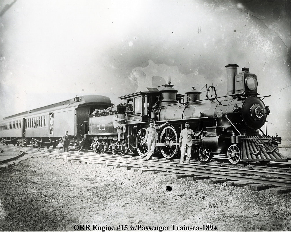
The crew of Ohio River Railroad 4-4-0 # 15 is paused with an eastbound passenger train in this circa 1894 scene at Millwood. The track diverging at left is the recently completed Ripley & Mill Creek Valley Railroad constructed to Ripley. John G. King/Dan Robie collection
|
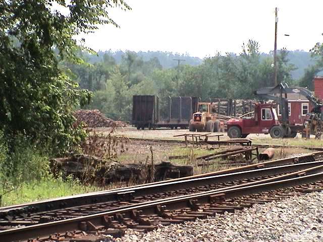
No industry developed at Millwood until after World War II. During the early years, it was an agricultural--specifically, fruit-- community and foremost, junction point. The Ripley and Mill Creek Valley Railroad joined the Ohio River Railroad here with a wye connection. It was also a coal and watering point as well as a livestock service location for cattle departing from market at Ripley and for livestock trains passing through. A station agent was on duty here and its telegraph call letters were MJ. B&O also maintained a 3200 foot passing siding here that was frequently the meeting point for passenger trains. During the 1960s, a pulpwood facility located here and during the early 1990s, Westvaco moved its lumber operation from Parkersburg to here although it was closed by the early 2000s. All that remains today on the railroad at Millwood is a passing siding for CSX known as “Kaiser” and on a personal front, memories of long ago.
|
The Westvaco Lumber Yard at Millwood as it appeared in 2003. A wood plant had been here since the 1960s and Westvaco moved here during the early 1990s. Operations ceased here during the early 2000s. Image Dan Robie 2003
|
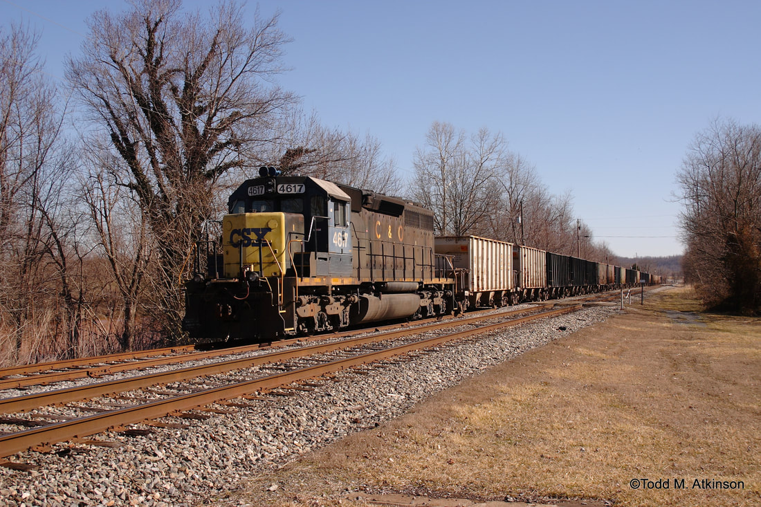
A westbound rock train occupies the Kaiser Siding at Millwood in March 2007. CSX SD40 #4617--the last locomotive on the roster to wear a predecessor scheme--is the lone power. This locomotive was recently restored operationally and to its original C&O paint and operates on the Buckingham Branch in Virginia. Image Todd M. Atkinson
Millwood was the epicenter of the family connection to the Ohio River Railroad and later the B&O. My maternal grandfather as mentioned earlier, witnessed the construction of the line as it passed through Jackson County. As a young man in his twenties, he rode Ohio River Railroad passenger trains although not frequently. His most direct association with the railroad was as a rural mailman—he delivered to the Millwood, Mount Alto, and Cottageville areas with a horse and buggy throughout his tenure never opting to purchase that revolutionary invention, the automobile. His daily fare consisted of picking up the mail that arrived on the trains. An amazing transformational life span he lived---born six years after the Civil War ended and lived to see the thermonuclear age of the 1950s. His wife, my maternal grandmother, had direct involvement with the railroad as a postal clerk sorting mail and daily interaction with B&O employees. The family farmed extensively at Millwood and the fertile bottom land near Schoolhouse Run between the railroad and the river produced corn in the summer and cabbages in the fall. My grandmother would share this abundance with the B&O men who stopped by as well as local friends. The hoboes, as mentioned in the Part I preface, were common during the early Depression and produce was shared with them also. By the late 1930s, my mother was of age to gain awareness of the daily life at Millwood and shortly thereafter became the family member that experienced train travel along the Ohio River most frequently.
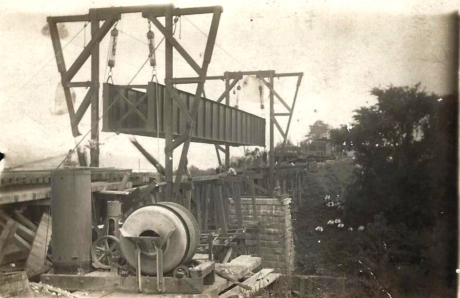
During the early 20th century, uncounted trestles and bridges were deemed inadequate to accommodate heavier locomotives. Work is progressing at Millwood to replace a trestle with a deck bridge spanning Little Mill Creek. Image Jackson County Historical Society
Two views of the railroad during the Chessie System era. A family home later purchased by an aunt is on the property directly above the railroad here. During summer months, this bank was loaded with blackberries--and black snakes. The view at left looks east towards Millwood and at right, the west view where the line enters the narrows separating Millwood and Letart. Both images Dan Robie 1981
Mason County
A damaged negative but the essence remains. Richard J. Cook photographed the twilight of the B&O Ten-Wheelers and he captured B8-a #1377 on Train #72 at Letart in 1947. A scene my father undoubtedly saw numerous times during the late 1940s. Image Richard J. Cook/ Allen County Museum.
Ever since my father passed in 2003, the trips through Letart are not without a heavy heart. There are many boyhood memories there with him fishing, exploring, and his recalling this small community across the Mason County line as it was in his earlier life. The Letart of the postwar period was what he was most familiar---a small agricultural region situated at bottomland along the river. Before the lock and dam was constructed a couple of miles downstream at Racine, OH in 1971, there were two islands in the river here but the increased river level submerged the smaller one. Many years ago, there were falls in the Ohio River of which the town across the river is so named—Letart Falls. Navigational dams submerged these falls during the early 1900s. Letart was also the site of a boat yard during its early history.
Never a large center of commerce for the railroad, the trains passed through Letart except for the passenger stops of which by that era, numbered few patrons. In the distant past, local agricultural produce was shipped by farmers here but not on a large scale. Later years witnessed small mining activity and a gravel quarry that operated using an overhead conveyor.
|
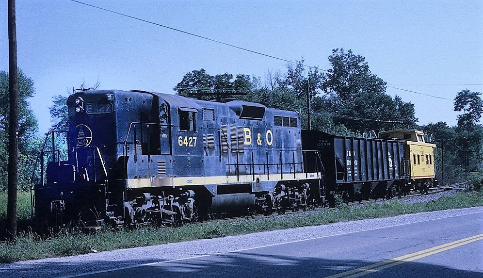
B&O GP9 #6427 with a local at Letart in 1970. This single hopper car was likely destined for the American Alloys plant at Graham Station. Image courtesy Marty Bernard.
|
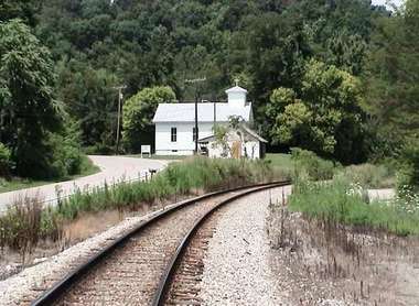
The Asbury United Methodist Church has been a Letart landmark for generations. Many a sermon and passing train has echoed off the walls of this house of worship. Dan Robie 2003
|
During the late passenger era, timetable adjustments resulted in frequent meets at Letart. In 1955, for example, Trains #72 and #73 had a scheduled meet here. This remained in effect until the trains were abolished in 1957 due to declining ridership. Because of the wide river bend here, my father claimed that he could hear the whistles and staccato of these and other westbound trains at Millwood and as distant as Ravenswood.
A CSX OCS (executive train) moves westbound from the Letart narrows into the bottomland at Graham Station in 2015. To the left of the train but not in the photo frame is the Racine locks and dam on the Ohio River. Image courtesy of Curtis Riffle
|
Until the 1940s, the expansive bottomland between the Letart narrows and the town of New Haven was primarily farm land populated with scattered homes. Known as Graham, or Graham Station, the railroad passed through the wide expanse with fertile land flanking it to either side. The first modern development to break ground in this area was the construction of the Appalachian Power Company Philip Sporn plant in 1948. My father had just began his career with Appalachian Power in that year and one his first duties of which to participate was the construction of the railroad track around the plant. A network of sidings was built but, ironically, the power plant never received coal by rail. As it was also located on the bank of the Ohio River, it opted to receive coal shipments by barge which it did for its entire life of operation. The railroad was built into the plant to move heavy equipment but was intact to receive coal by rail if necessary. The Philip Sporn plant remained active until it was decommissioned in 2015 as a result costly upgrades and tighter environmental regulations.
|
The spur to the former American Alloys (Felman) plant where it crosses WV Route 62. Weeds have overtaken the track and from appearances where it crosses the asphalt, no activity on this track. A far cry from B&O years when the plant generated large carloads for the railroad. Image courtesy Curtis Riffle
|
|
In 1952, the next industry to locate at Graham was the Foote Mineral Company, a manufacturer of metal alloys. This plant generated considerable carloads for the B&O and continued into the CSX era. Ownership changed hands several times--American Alloys, Highlander, and Felman the subsequent operators. The plant is located on the opposite side of the railroad and WV Route 62 from Philip Sporn.
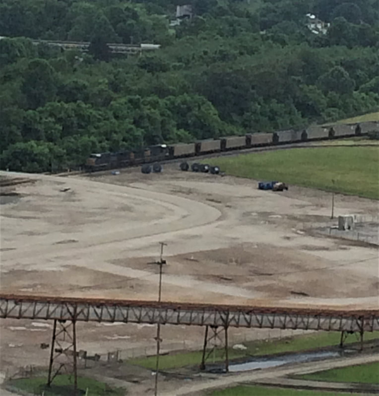
At left: A contemporary image of a CSX coal train at the Mountaineer power plant. This facility has primarily received coal by river transport but also utilizes the railroad as needed. This photo was taken from atop power plant complex in a view that looks railroad west.
|
The year 1982 witnessed the activation of a modern power plant adjacent to Philip Sporn called Mountaineer. Like the Sporn plant, there is railroad track within the complex but it, too, mostly receives coal by river barge. With the shutdown of the Philip Sporn plant, Mountaineer remains the sole active plant with employee and power network consolidations.
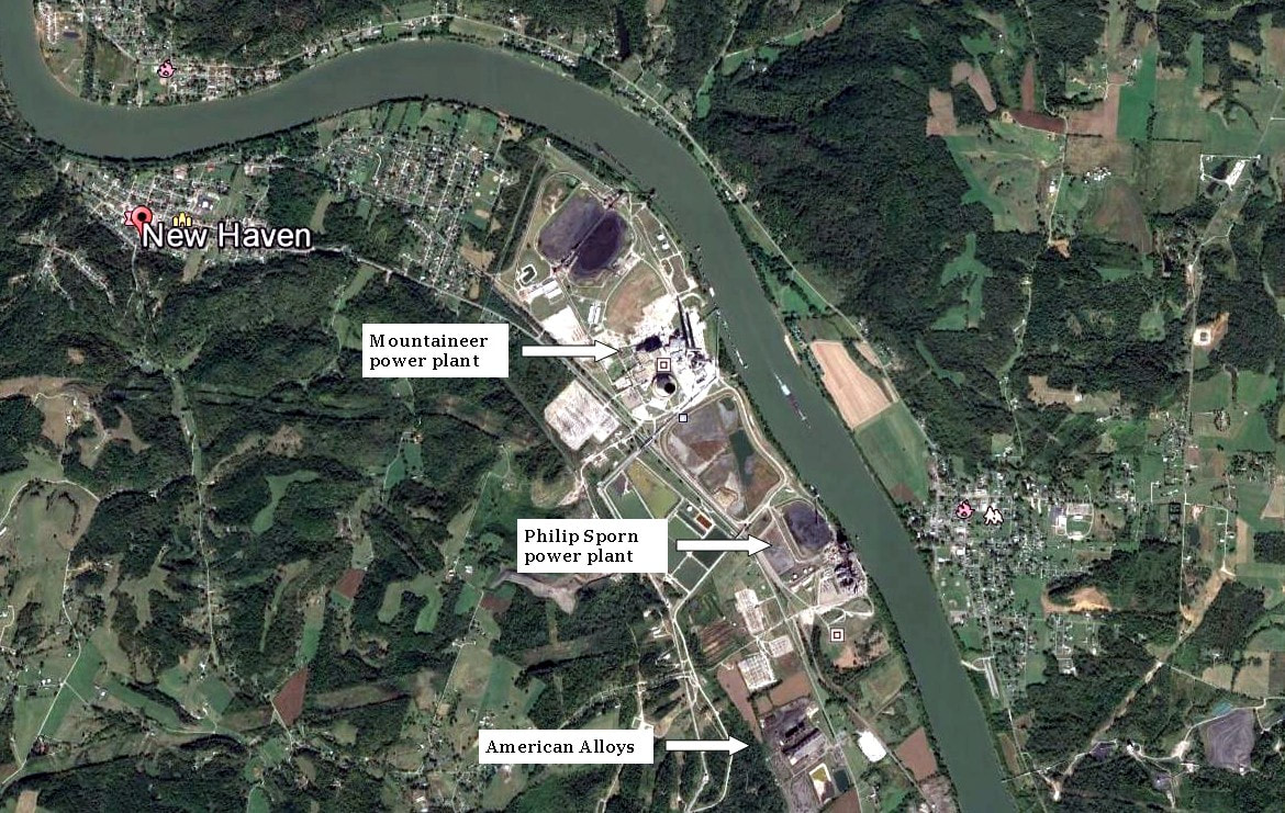
A Google Earth view of the Graham Station region extending to New Haven. What was once farm land became the site of two power plants---Philip Sporn and Mountaineer--and the American Alloys (Felman) manufacturing plant.
|
An Ohio River Railroad camp train at New Haven in 1894. Essentially an early era maintenance of way train with workers spending days on the line for repair and maintenance. Image John G. King/Dan Robie collection
|
During the mid-1920s, the State of West Virginia sponsored "agricultural trains" that traveled the state promoting the merits of agriculture. This is one of those promotional trains at a station stop in New Haven. Image West Virginia and Regional History
|
Again, George Washington left his stamp along this region of the Ohio River having surveyed land between Letart and Point Pleasant. This was bounty land as spoils from the French and Indian War that the future giant of American history distributed to his fellow officers. Nearly a century later, a taste of Connecticut found its way to the Ohio Valley during the 1850s resulting in towns founded sharing the same name as two in that New England state, New Haven and Hartford (City). The area became an industrial pocket of Mason County first with coal mining and the later salt industry.
|
Early 1900s view at Hartford with the depot at right center. The salt industry--already established during the Ohio River Railroad years--continued to prosper well into the B&O era. Image Mason County Historical and Preservation Society
|
One of the salt plants at Hartford during the early 1900s. The Hartford Salt Works as it appeared in 1913. Image WV Geological Surveys
|
The region thrived for nearly a century--particularly at Hartford--with mining activity. By 1921, two mines remained active--the Jackson Coal and Mining Company and the Mason Coal and Chemical Company. Greater in economic impact and legacy, however, was the salt industry. The early salt history origins of West Virginia were concentrated in the Kanawha Valley south of Charleston in what is present day Malden. By the time of the development of the industry along the Ohio, the quantity was greater and market accessibility easier. So dominant was the output along the Ohio at Hartford, Mason, and Pomeroy across the river that it supplanted the great salt works that lined the Kanawha. Among those operating at Hartford during the early 1900s at Hartford were the Liverpool Salt and Coal Company and the Hartford City Salt Company. Both were served by the Ohio River Railroad and subsequently the B&O and the industry remained active until the early 1960s.
|
The B&O passes between the Hartford Salt Furnace and Siding Hill cut. Early Hartford scene circa 1912. Image WV Geological Surveys
At right: Aerial view of the Liverpool Salt Works at Hartford. One of the great salt plants along the Ohio River, it was the last to operate in Mason County ending a century of operation in 1963. Image West Virginia and Regional History
|
In its 1948 report, B&O listed the following concerning the New Haven and Hartford area: at New Haven, a water station and an 1100 foot passing siding. The shippers listed in Hartford at this date were the American Calcium Chloride Company, Liverpool Salt and Coal Company, Fuel Process, and the Jackson Mine. Hartford was also the location of a station agent with telegraph call letters DK and a 2300 foot passing siding. CSX trains pass through Hartford today oblivious to its industrial past.
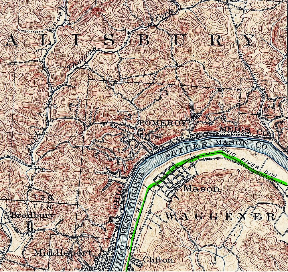
1907 topo map of the Mason area which also includes Pomeroy, OH. Both were related economically (salt industry) as well as tightly knit community ties. Personal family history is also prevalent in this region.
|
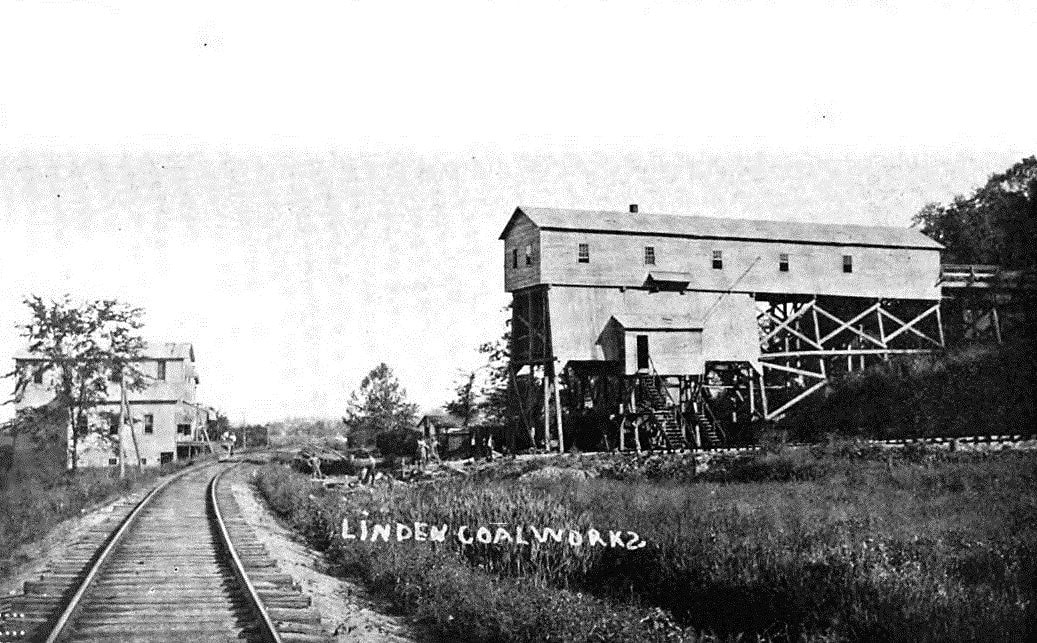
The Linden Mine was one of three active coal mines at Mason during the 1920s. This view looks railroad eastbound. Image West Virginia Geological Surveys
|
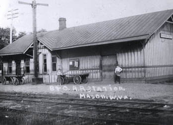
The B&O depot at Mason circa 1920. Standard design appearing similar to others along the Ohio River Railroad. Image John G. King/Dan Robie collection
|
|
The Hogg and Zuspan Lumber Yard is a small shipper located at Mason. Two centerbeam cars have recently arrived with lumber products.
|
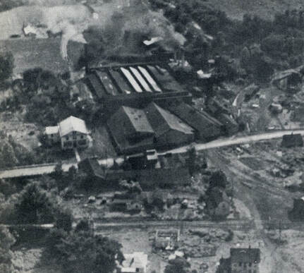
Situated in the heart of the old Mason County historical pocket is the town of Mason (City). Like its neighboring communities, early coal mining in addition to the booming salt industry which defined its early 20th century economy. In conjunction with the salt business across the river in neighboring Pomeroy, OH, both banks of the Ohio prospered. Foremost in Mason was the Ohio River Salt Company which was a large industrial complex. It appears that this company operated under two previous names--the Dixie Salt Company and the Hope-Mason Salt Company. Coal mines remaining in operation at Mason during the early 1920s were the Gress Mining Company, Linden, and Icenhower Mines. To the west of Mason at Clifton, the mining and salt industry also left an imprint but had subsided by the turn of the century. As of 1921, the Clifton Mining Company remained in business.
|
|
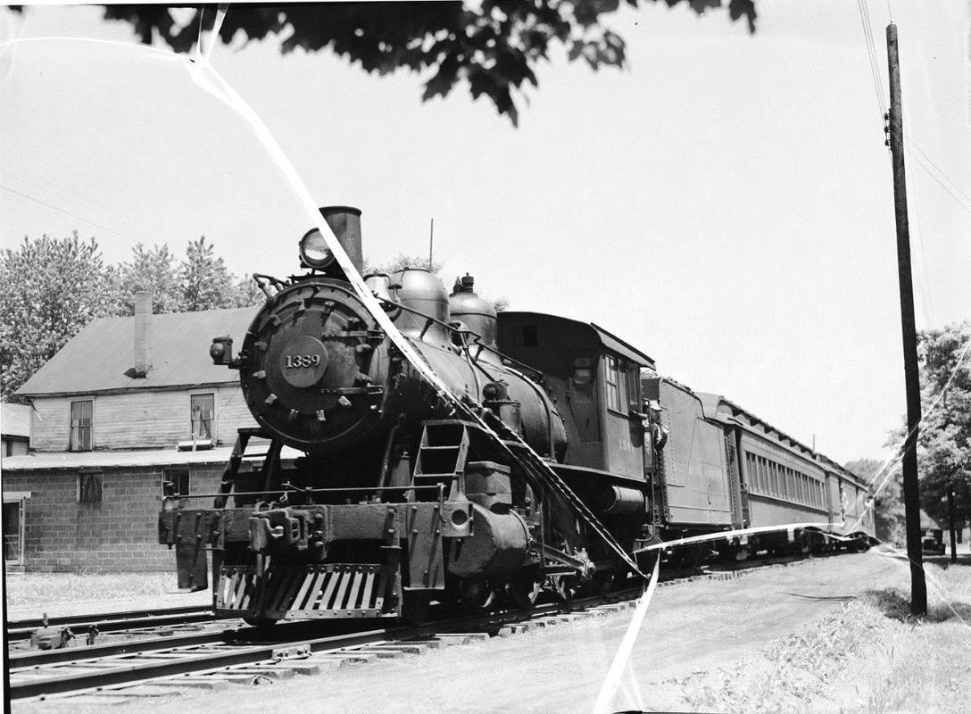
Damaged negative of Train #81 with B8 4-6-0 #1389 departing Mason for Kenova in 1947. Richard J. Cook roamed the Ohio River line and its branches to photograph the final years of the Ten Wheelers. Image Richard J. Cook/Allen County Museum
|
A 2010 image of a CSX Q316 moving eastbound through the community of Clifton. The red HLCX SD40-2 leaser locomotive stands out in vivid red. Image courtesy Curtis Riffle
|
As of the late 1940s, B&O listed the Ohio River Salt Company and the Fuel Process Company as active shippers. The station was manned by an agent and the telegraph call letters were MY. No servicing facilities were located here but a 900 foot passing accommodated meets and switching. A contemporary shipper located at Mason is the Hogg and Zuspan Lumber Yard which is accommodated with a spur.
Mason held a connection with my father's side of the family. His brother lived at Mason for the last half of his life operating a concrete business but the railroad played little if any affairs here. To this day, his children and grandchildren still reside in the region. My paternal grandparents, who had lived at Evans and Letart previously, moved across the river to Pomeroy during the 1950s where they resided for the remainder of their lives.
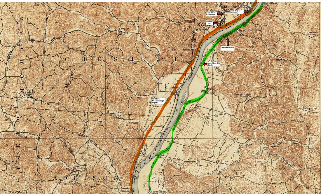
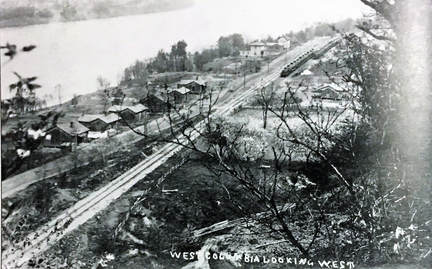
A 1906 topo map of the region between Mason and Point Pleasant. The railroad (green) enters narrows at West Columbia then emerging into wide bottomland that includes the hamlets of Spillman and York. On the Ohio side of the river is the Hocking Valley Railroad (orange)(later Chesapeake and Ohio) to Middleport and Pomeroy.
|
West Columbia as it was during the early 1900s. Although presenting the appearance of an active industrial setting, in truth, its heyday had passed. Miners homes still line the road and tank cars occupy the sidings in the distance. Image Mason County Historical and Preservation Society.
|
In a section of narrows essentially separating Mason from Point Pleasant was the first large industrial town to establish along the Ohio River in Mason County. West Columbia, as it would be named, preceded its neighboring communities in tapping its natural resources during the antebellum period. Coal was mined here and small scale salt works were established which resulted in West Columbia becoming the largest town in Mason County. But by the late 1800s, the resources had been tapped and area was in decline. It soon was superseded by an expanding town at the mouth of the Kanawha River, Point Pleasant. To the immediate west of West Columbia, other communities such as Spillman and Hallwood supported active coal mines. By the 1940s, little remained of this industrial pocket in the narrows but B&O listed the Jeanne Ann Mine as still active at Hallwood.
|
B&O also constructed a 3700 foot passing siding at Lakin which remains active but lengthened in current CSX operations. The small community at York was the location of a wye and the west connection for the West Virginia Ordinance.
Point Pleasant
A 1906 topo map of Point Pleasant and the surrounding region. In 1886, the Ohio River Railroad (green) reached the city and in 1892 another road did likewise, the Kanawha and Michigan Railroad (yellow), which used a section of Hocking Valley Railroad (orange) rails in Ohio . The confluence of the Kanawha and Ohio Rivers had long established Point Pleasant as a major center of river commerce.
Point Pleasant has garnered a mystique of sorts among contemporary generations not native to the area. If not known for tragedy of the Silver Bridge then certainly images of the Mothman fill the modern day view screen. But before either, Point Pleasant was as other towns and cities along the Ohio River. Its history is diverse—a battle fought there in October 1774 between Virginia militia (Lord Dunmore’s War) and Shawnee Indians—has been debated, pro and con, as the “first battle of the American Revolution”. Owing to its location at the confluence of the (Great) Kanawha and Ohio Rivers, it was a strategic location militarily, a gateway from Appalachia to the Midwest, and a commercial crossroads. Always a river city, its commerce was dominated by the river boat and it later contributed to the manufacturing of river vessels. Into this backdrop arrived the railroads during the late 19th century---first the Ohio River Railroad in 1886 and the Kanawha and Michigan Railroad in 1892. The junction of the two railroads connected Point Pleasant to the rapidly expanding rail network.
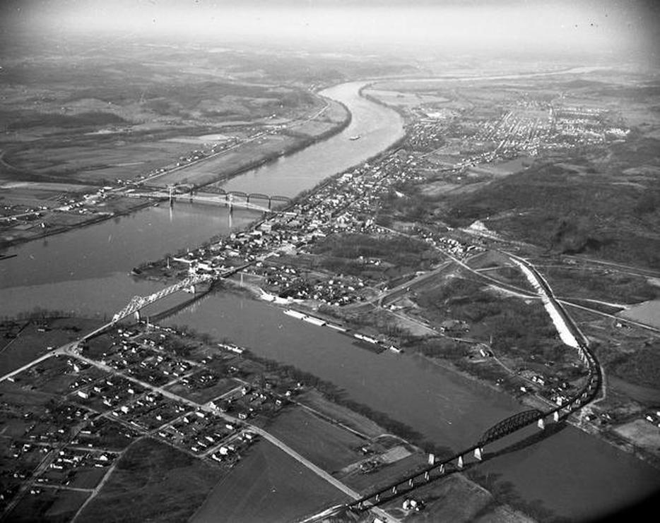
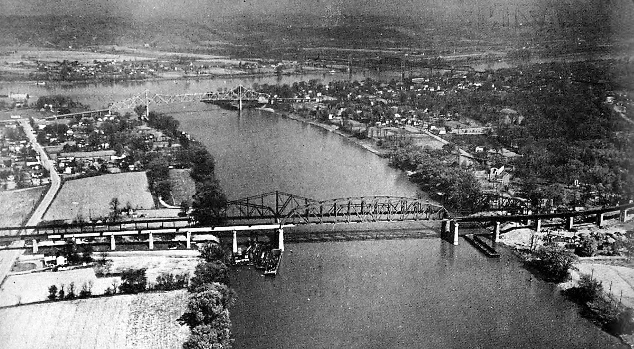
A 1952 aerial photo that provides an exceptional view of Point Pleasant as it was mid-20th century. Looking north from the confluence of the Kanawha and Ohio Rivers, the K&M (New York Central) bridge spans the Ohio and adjacent to it, the ill- fated Silver Bridge that would tragically collapse fifteen years later. The Shadle Bridge spans the mouth of the Kanawha connecting Point Pleasant and Henderson and upstream from it, the relatively new 1947 B&O bridge. The route of the B&O can be traced through Point Pleasant paralleling the Ohio River. Image Huntington Herald-Dispatch
At the north end (railroad east) of Point Pleasant was a cluster of B&O shippers as well as a small yard at a place name known as Baden. The most notable of these shippers was the Marietta Manufacturing Company which constructed both domestic and military craft. It began operation in 1915 and remained in business until 1972 when it was purchased by Amherst Industries. Under this ownership, the company continued production until closing in 1984.During its existence, the business constructed military boats during World War II, the Korean War, and Vietnam.
|
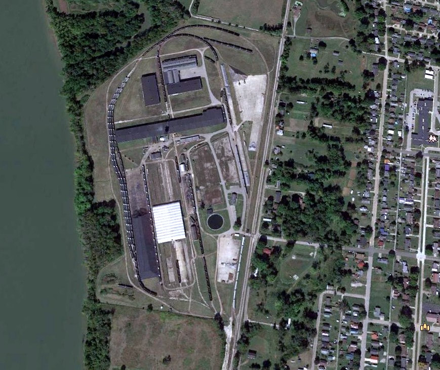
Aerial view of a section of the former Marietta Manufacturing (Ship Yard) Company at Baden on the north side of Point Pleasant. Now used for railcar storage, this would make an interesting project on a model railroad.
|
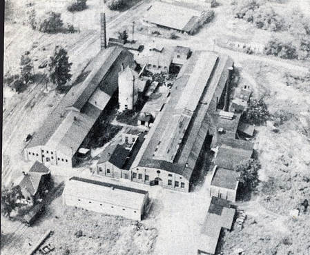
The West Virginia Malleable Iron Company was a B&O shipper for many years. This plant was located at Baden adjacent to the yard trackage. Image West Virginia and Regional History
|
Other shippers near the Baden area in the postwar era included the West Virginia Malleable Iron Company, Point Pleasant Lumber Company, Point Pleasant Livestock Auction, Farmers Cooperative, Standard Oil, and the Gulf Oil Corporation. B&O also utilized a 1900 foot passing siding along with several storage tracks. Baden also included a wye and servicing facilities for water and livestock.
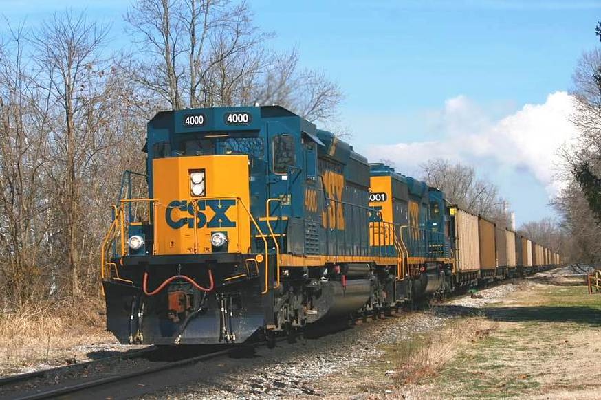
A train of empty hoppers move westbound past Baden Yard. The first two SD40-3 rebuilds from the Huntington Shops, #4000 and #4001, receive their baptism of service on the Ohio River Subdivision. Image courtesy of Curtis Riffle.
Another pocket of shippers at Point Pleasant was located at the depot area. In addition to the active interchange with the New York Central, the Carolina Lumber Company, E. H. Hawks, and the Roush Brothers were served in that immediate vicinity. As for the interchange itself, it was busiest during the B&O-New York Central years merely because of higher volume and the number of shippers in existence. The connection still remains today---CSX and the present day Kanawha River Railroad.
|
The union passenger station at Point Pleasant that served both the Ohio River Railroad and Kanawha and Michigan Railroads. Actually a bi-level layout with the K&M tracks above and the ORR tracks below. Image John G. King/Dan Robie collection
|
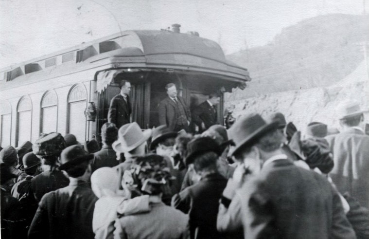
Former President Theodore Roosevelt at a whistle stop in 1912 when running for a third term on the "Bull Moose" platform. Campaigning to thwart the reelection of President Taft, the ploy split the Republican vote and Woodrow Wilson won the election. Image West Virginia and Regional History
|
|
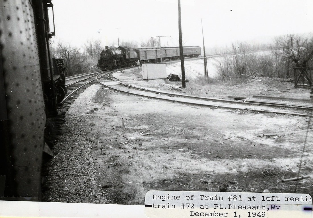
Eastbound Train #72 has just crossed the Kanawha River bridge on the approach to the depot. In the siding waiting for it to pass is Train #81 in this December 1949 scene. Image John G. King/Dan Robie collection
|
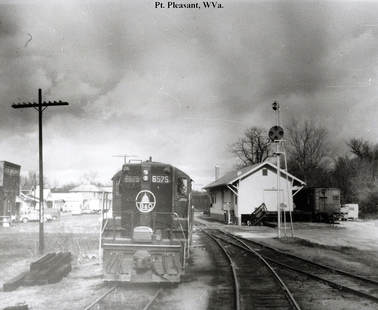
B&O GP9 #6575 is in the passing siding in this late 1960s photo near the depot. Note the train order signal that will display green or red as to whether a train must stop. One of few signals to be found on the Ohio River line. Image John G. King/Dan Robie collection
|
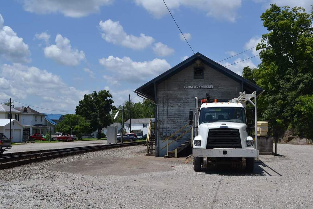
A note about the Point Pleasant depot--it is not an original B&O structure. The old union station that stood here was dismantled circa 1960 as passenger trains had ceased prior to that date. B&O purchased a New York Central freight station and moved it by flatcar to its location as a replacement. The "new" depot served the B&O as an office and freight station and is utilized today by CSX for storage.
1967 and 2017
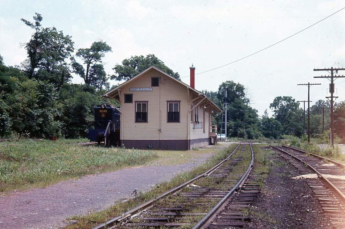
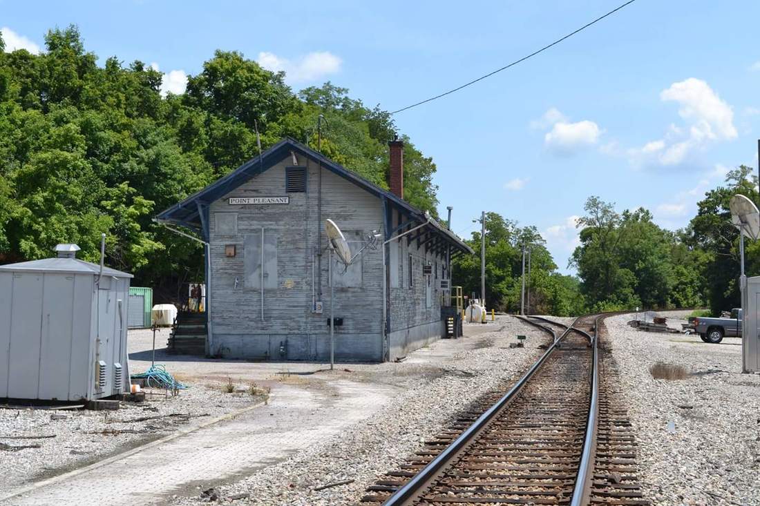
A pair of then and now views of the Point Pleasant depot separated by exactly 50 years--July 1967 and July 2017. Images contributed by F. Douglas Bess, Jr.
These views look railroad west. In 1967, the passing track, the train order signal, code line poles, and jointed rail and the track behind the depot with the local switcher fill the view that retains an element of charm. A half century later, technology has encroached--depot boarded up in primer gray, welded rail, communication box and dishes--the generic face of modern railroading. Images F. Douglas Bess, Jr.
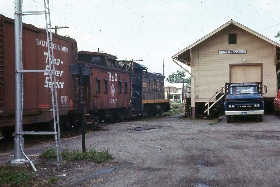
Opposite view of the depot. At left, the Point Pleasant local with an all B&O consist; the mast of the train order board and the GMC pickup truck enhance the 1967 scene. At right, a CSX maintenance of way truck occupies an otherwise dormant setting. Note there is longer a track at the rear of the depot. Images F. Douglas Bess, Jr.
a Tale of Two Bridges
The story of Point Pleasant is also the tale of two bridges. One remained in service past its practical life span restricting railroad operations thereby delaying additional expansion. The other remained in service past its practical life span and tragically cost human lives forever changing a city and surrounding region.
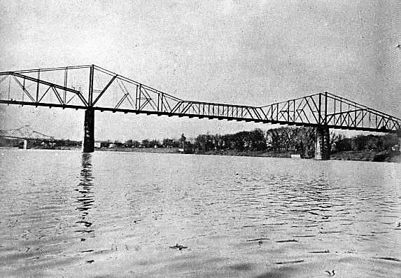
Spanning the Kanawha River was a cantilever bridge constructed by the Ohio River Railroad as the line expanded west towards Huntington. Constructed to satisfy the standards of motive power and rolling stock of the era, the span remained adequate until the early years of the 20th century. However, the railroads—including B&O—were upgrading to new, heavier power as it developed and freight cars followed suit. Newer locomotives such as heavy 2-8-0s, 2-8-2 Mikados, and the new standard of passenger power, the 4-6-2 Pacific, supplanted the older 4-4-0s and 4-6-0s—but exceeded weight limits of the Kanawha River Bridge. But this was a situation that B&O and all other roads faced at uncounted locations---replacing obsolete bridges. Obviously, the high volume main lines were first priority---of which the Ohio River line was not. Later, B&O financial hardships and the Great Depression further postponed its replacement. So for more than 30 years, the Kanawha River Bridge was an albatross forcing B&O to operate the Ohio River line as a two entities with respect to motive power. Heavier locomotives were restricted to the line east of Point Pleasant—any westbound through trains traversing the route had to swap to lighter power---typically at Parkersburg. The Kanawha River Bridge is the sole reason that the 4-6-0 Ten Wheelers remained in service until the 1950s—the west end of the railroad between Parkersburg and Kenova was their final domain. Finally, in 1947, B&O replaced the structure with a heavy combination truss/deck bridge just in time for diesels and the postwar industrial expansion in the Ohio Valley. The albatross was eliminated.
|
The original Ohio River Railroad cantilever bridge spanning the Kanawha River. Its light construction--and obsolescence--hampered B&O operations until its 1947 replacement. Image B&O Magazine
|
A 1947 photo of the new truss bridge and the 1880s cantilever on the opposite side. The new bridge was dedicated with fanfare by the B&O eliminating a major obstacle to modern industrial development in the Ohio Valley. Image B&O Magazine
|
|
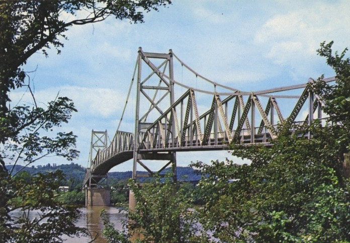
As of this writing (2017), it is the 50th anniversary of the tragic collapse of the Silver Bridge at Point Pleasant on a cold December 15, 1967 day that took 46 lives and changed a region forever. The years since its collapse are known as “after the bridge fell”. All that possess a memory of the bridge and experienced that terrible day are advancing in years now but as long as they live, the horrific events of that tragedy will remain a living memory. The loss of life was foremost but the economy of Point Pleasant and the neighboring communities on both sides of the river was adversely affected as well. My family formed a bond with Point Pleasant from earlier years—I spent many summer days there with my father long ago and retain a nostalgic connection to it. An aunt and uncle crossed that bridge the day it fell but did not speak of it until years later. Every December 15, I give a moment of remembrance and a prayer for those lost and for those who remain in a place rooted in my past with fondness.
|
The Silver Bridge spanned the Ohio River connecting Point Pleasant and Kanauga, OH from 1928 to 1967. Due to design and neglect, an eye bar failure caused a cataclysmic collapse into the Ohio River taking with it 46 lives. This bridge had a twin spanning the Ohio River at St. Marys, WV that was dismantled after this tragedy. Image West Virginia and Regional History
|
West Along the Ohio
Q317 crosses the Kanawha River from Point Pleasant into Henderson as it moves westbound to Huntington. SD40-2 #8049 and GP38-2 #2563 lead the daily manifest on this July day in 2002. Image Todd M. Atkinson
Moving south (railroad west) of Point Pleasant, the present day Ohio River line remains similar to as it did a century ago. For reasons unbeknownst, the Ohio River Railroad west of Point Pleasant extending to Huntington received scant attention from the photographer. The dearth of coverage continued into the B&O years and even today in the CSX era, this region is the least photographed. Perhaps it was the lack of industry as this sector of the railroad was---and remains—predominately farmland and small towns. However, the region as it is today is not completely undeveloped as a pair of large shippers do exist in the modern era. Inasmuch, this section of Part II will be substantially less in content as opposed to the other regions. If additional information and/or images are obtained in the future, the page will be updated accordingly.
After the westward crossing the Kanawha River, the railroad passes through Henderson, the town on the opposite bank from Point Pleasant. B&O did not list any shippers of record here although a company siding was located here for perhaps use as a team track in earlier years. The track moving west was constructed on the bank of a short narrows for the purpose of gaining elevation eastward for the approach to the Kanawha River bridge. Upon emerging from this narrows, the railroad moves west through wide bottom land extending for miles to Cox Landing. This is the straightest region within the length of the Ohio River Railroad--long tangents with gradual curvatures transitioning the linear sections.
Ohio River Railroad locomotives such as 4-6-0 #20 pictured here in 1891 would replenish with coal as needed at Gallipolis Ferry. Its B&O successors would continue the practice until the 1950s. Image Baltimore and Ohio Railroad
|
Train #73 runs westbound from Henderson into Gallipolis Ferry in June 1947. Soon, the 4-6-0s would be exiled to the Ripley and Spencer Branches. Photo Richard J. Cook/Allen County Museum
|
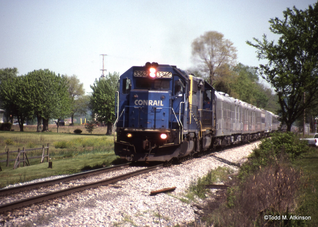
Conrail and CSX pair up on a RBBB Circus Train running westbound through Gallipolis Ferry in April 1998. This was the last circus train to traverse the Ohio River Sub. Image Todd M. Atkinson
|
From the Ohio River Railroad years until the B&O of the 1970s, no large shippers existed at Gallipolis Ferry. It was, however, an important location along the railroad during the steam locomotive era. The depot included an agent and telegraph station will the call letters XY with a passing siding 1500 feet in length. A storage siding also existed here (and still does) possibly used for agricultural and livestock purposes in earlier years. As late as 1948, B&O continued to list Gallipolis Ferry as a livestock watering point and an all-important coaling station--the last moving westward until Huntington.
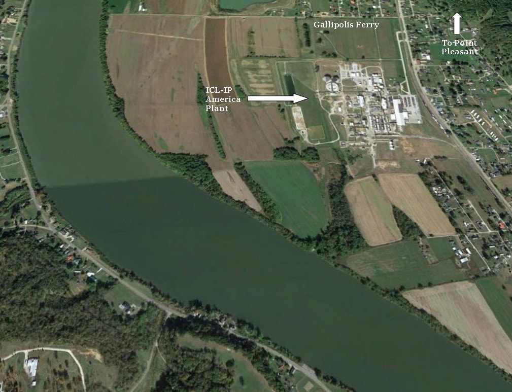
The ICL-IP America Plant in the bottom land at Gallipolis Ferry is a sizeable shipper for present day CSX and one of two plants constructed in the area during the 1970s. The Ohio River is wider here--enlarged by both the infusion of water from the Kanawha River and the Gallipolis Lock and Dam. It is easy to see why the bottom lands of the river were--and remain--prime agricultural territory.
During the 1950s, Celanese Chemicals announced it had selected a site at Gallipolis Ferry to construct a plant creating both area jobs and increased traffic for the B&O. By 1974, the Stauffer Company had succeeded Celanase Chemicals and the plant has remained in operation since although ownership has changed twice. Stauffer was taken over by Akzo which in turn, was purchased by the current operator, ICL-IP America. The business remains a large shipper for CSX.
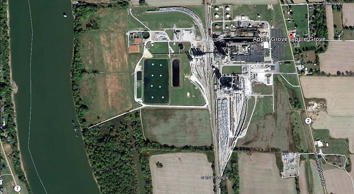
Directly to the south (rail west) of the Gallipolis Locks and Dam is the town of Apple Grove. It would be assumed that it was named for such---groves of apple trees—but could not locate any historical references to that effect. Whether apples were indeed grown or not, one fact is for certain—other produce was. The fertile bottom lands here produced generations of crops and farming continues to this day. A major change occurred in 1974 when the Goodyear Tire and Rubber Company announced plans to construct a large resin plant at the location. Once this industry began producing, it became a tremendous source of traffic for the B&O and continues today for CSX although under the name of M&G Polymers.
Google Earth view of the Goodyear resin plant constructed at Apple Grove during the mid-1970s. The industry is now known as R&M Polymers and volume of the rail traffic at this plant is clearly evident.
Other names that appeared on the railroad timetables of yesteryear between Gallipolis Ferry and Apple Grove in this area are Elwell, Ben Lomond, and Hogsett. B&O listed a 2800 foot passing siding at Apple Grove—the siding remains in the CSX era and is referred in modern parlance as the Ben Lomond siding. It is the only passing siding remaining on the railroad between Point Pleasant and Huntington. West of Apple Grove is a short siding at the hamlet of Ashton and B&O once listed a passing siding at Glenwood at 1000 feet in length.
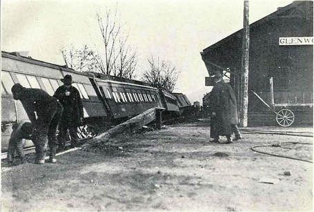
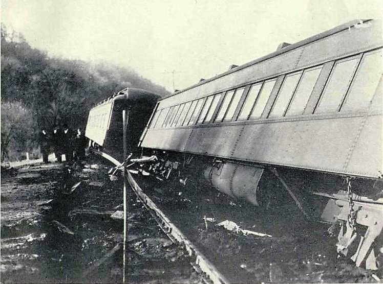
There exists an ICC record of a derailment on the Ohio River Railroad that occurred on December 11, 1919 involving a passenger train en route from Kenova to Pittsburgh. Nine passengers and one railroad manager were injured in the accident.
B&O Train #78 with locomotives #1410 and #1408 (a pair of Class M 4-4-0s), a combination baggage/mail car, an express car, two coaches, two sleepers, another coach, and two more baggage cars departed Kenova at 10:20 PM. After a station stop at Huntington, it departed at 11:12 PM and proceeded for 26 miles at 43 MPH whereupon it derailed at Glenwood at 11:50 PM. The lead engine, #1410, did not derail but the #1408 left the track entirely with only its pilot wheels still on the rails coming to a stop 710 feet beyond the derailment point. The trailing cars separated from the tender with only the last three remaining upright and on the track. The engine crew of #1410 did not notice anything unusual upon approaching Glenwood but shortly thereafter felt the application of emergency brakes. In the trailing engine #1408, the engineer felt the train lunge and attempted to apply the brake but the motion of the locomotive prevented him from reaching the cut out cock until it came to a stop.
B&O Train #78 with locomotives #1410 and #1408 (a pair of Class M 4-4-0s), a combination baggage/mail car, an express car, two coaches, two sleepers, another coach, and two more baggage cars departed Kenova at 10:20 PM. After a station stop at Huntington, it departed at 11:12 PM and proceeded for 26 miles at 43 MPH whereupon it derailed at Glenwood at 11:50 PM. The lead engine, #1410, did not derail but the #1408 left the track entirely with only its pilot wheels still on the rails coming to a stop 710 feet beyond the derailment point. The trailing cars separated from the tender with only the last three remaining upright and on the track. The engine crew of #1410 did not notice anything unusual upon approaching Glenwood but shortly thereafter felt the application of emergency brakes. In the trailing engine #1408, the engineer felt the train lunge and attempted to apply the brake but the motion of the locomotive prevented him from reaching the cut out cock until it came to a stop.
Two photos of the Glenwood derailment taken the following morning. At left, an eastbound view that also offers a glimpse of the Glenwood depot. On the right, looking west at the derailed cars and mangled track. Images ICC Archives
An examination of the track discovered a broken rail behind the rear of the last sleeping car. A track inspector had examined this section of the railroad earlier that day but found no defects. The final ICC summary indicated there was no fault of crew or defective equipment attributable to the derailment. Final determination was the broken rail was solely responsible.
|
Moving west from Glenwood and crossing into Cabell County, the railroad continues its trek through bottomland that continues to host farming in the fertile ground. Few are the changes that have occurred in the region between Glenwood and Guyandotte since the Ohio River Railroad constructed the line through there—at least from a commercial standpoint. The most significant development in recent times is residential expansion as a result of the plants upriver and certainly, as bedroom communities for the Huntington area workforce. In essence, it is a blend of old and new. Small communities with names such as Homestead, Crown City, Green Bottom and Lesage dot this region of the railroad and river. B&O listed a storage siding at Lesage and as late as the early CSX era, a small shipper named United Grocers was also located there. It appears to no longer be active.
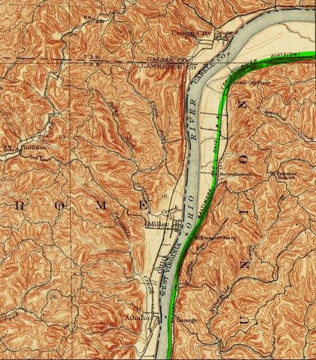
Topo map at right covers the territory between Glenwood and Cox Landing in Cabell County. This region is a mix of farm land and residential areas.
|
West of Lesage, the railroad enters the realm of Huntington as it passes through Cox Landing and then enters Guyandotte. The end of the present day CSX Ohio River Subdivision is only a few miles away but the story of the Ohio River Railroad continues westward in a region where it has long since perished.
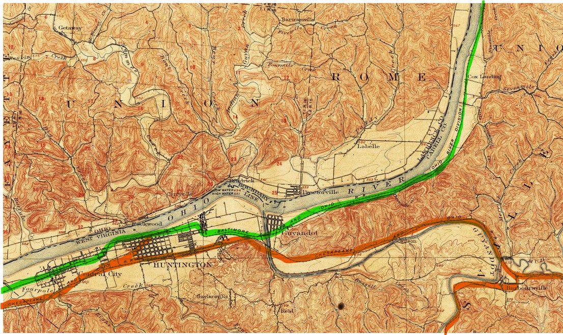
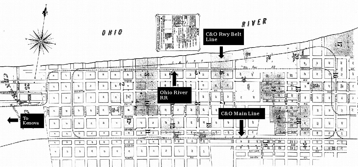
The original route of the Ohio River Railroad (green) through Guyandotte and Huntington is indicated on this 1901 topo map. Foremost a Chesapeake and Ohio Railway (orange) location, the Ohio River Railroad reached the city fifteen years afterward in 1888. The Guyandotte/Huntington area would prove to be the crown jewel for B&O in terms of quantity of shippers along the Ohio River line.
|
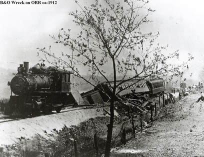
A circa 1912 passenger train derailment on the west end of the railroad. The late John G. King believed this photo to be taken near Cox Landing. Image John G. King/Dan Robie collection
|
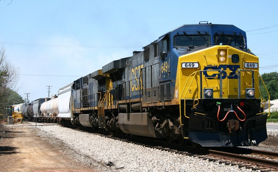
Q316 led by CW60AC #649 has started its eastward trip along the Ohio River. Train is moving from Guyandotte into Cox Landing. Image Matt Robie 2007
|
Huntington
In 1888, the Ohio River Railroad reached the Guyandotte River for its construction henceforth into Huntington. It was a similar situation that the road had encountered at Wheeling, Benwood, and Parkersburg—it entered a territory already established by another railroad which in this instance was the Chesapeake and Ohio Railway (C&O). The C&O had constructed its right of way to what would become the south side of the city leaving the only entry for Ohio River Railroad on the north side. That the ORRR would be required to construct its line in a meandering fashion within an already established inner city proved to be fact. In one respect, construction of the line was complete. A small line, the Huntington and Big Sandy Railroad was built extending to Kenova in 1890. The Ohio River Railroad would lease and operate this extension by 1893. When B&O absorbed the Ohio River Railroad, it also incorporated the Huntington and Big Sandy Railroad completing its Ohio River route to Kenova.
|
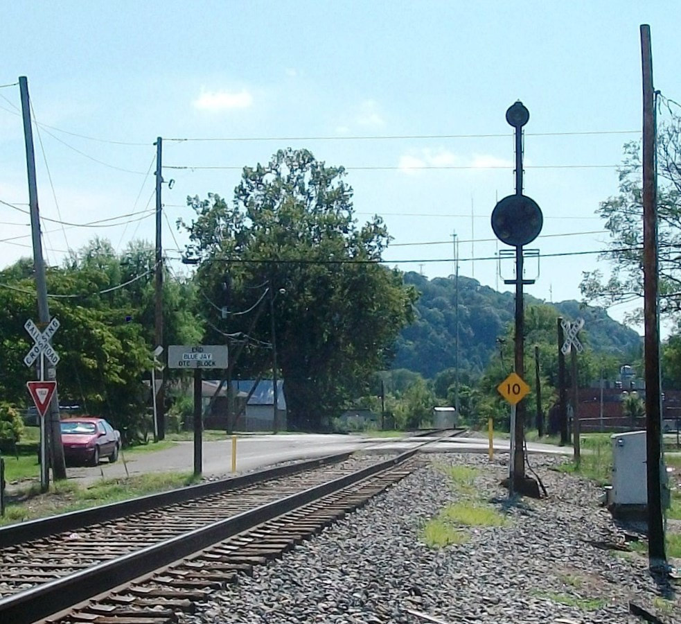
This B&O color position light stood vigil at Guyandotte for years until it was recently replaced. This signal displayed an aspect permitting or restricting trains on the B&O entering the C&O main. Note the 10 MPH speed restriction. Image Jonathan Spurlock
|
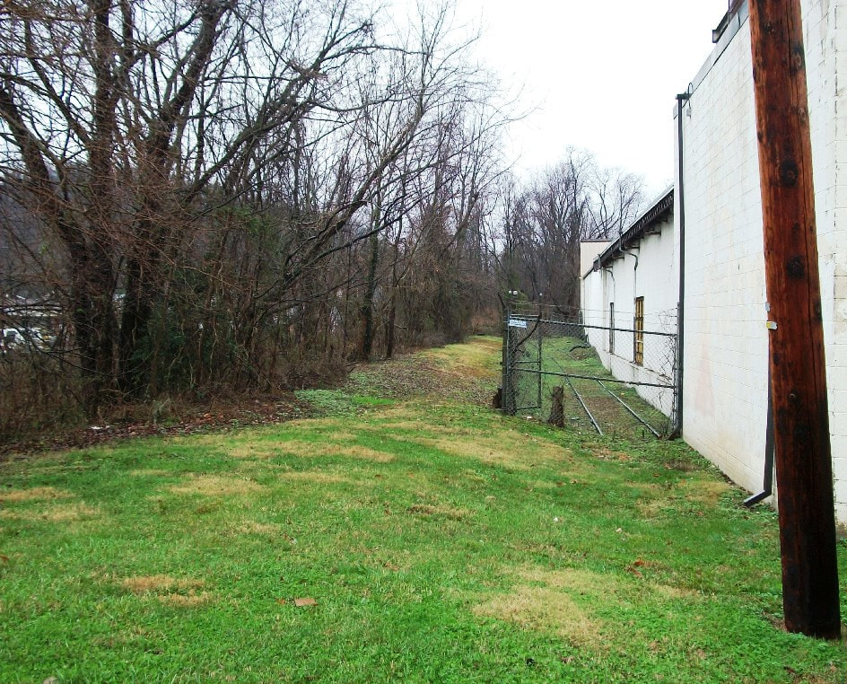
A short section of the original Ohio River Railroad was left intact extending to the Guyandotte River bridge to serve this industry. It was later removed and is marked by the tree line. The spur to the former shipper remains. Image Jonathan Spurlock
|
|
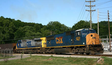
A train of empty hoppers led by SD70MAC #4830 is completing its westward journey along the Ohio River at it passes through Guyandotte. The connection with the former C&O is around the curve. Image Matt Robie 2007
|
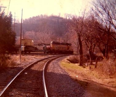
Looking at the relocated B&O junction with the C&O. A work train running westbound passes by on the C&O led by a Chessie System GP30. Dan Robie 1980
|
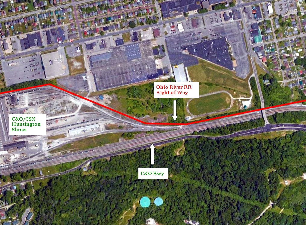
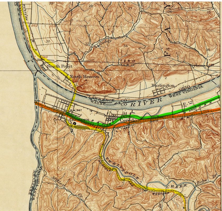
The railroad entered Guyandotte on a tangent passing through the south end of the community until crossing the river of the same name on a girder plate bridge. It continued until meeting the C&O briefly before turning north at what is now the US 60 overpass. Running northwesterly, it turned and ran past the north side of the C&O Shops (now CSX shops) until crossing C&O Belt Line (industrial loop) whence it turned north passing to the east of Marshall University Fairfield Stadium. The line continued north crossing US Route 60 (3rd Avenue) then turned west near 22nd Street where it ran down 2nd Avenue eventually paralleling the C&O River yard. Near 3rd Street, it again crossed C&O Belt Line and then turned south at 1st Street. The railroad again turned westward entering the area of Huntington known as Central City. Running on a tangent, the right of way crossed C&O industrial trackage and entering West Huntington passing between Adams (US Route 60) and Jefferson Avenues eventually paralleling 5th Avenue West. At the west end of Huntington, the Ohio River Railroad briefly met the C&O main line paralleling it until turning northwesterly to cross Fourpole Creek entering Wayne County and the town of Ceredo.
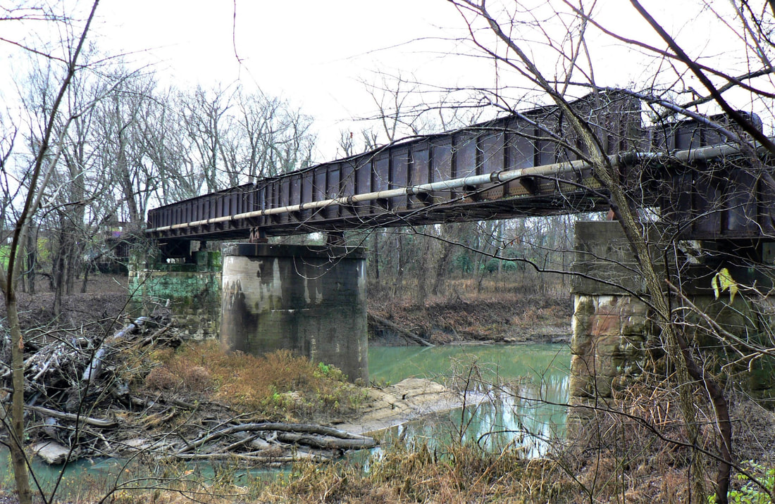
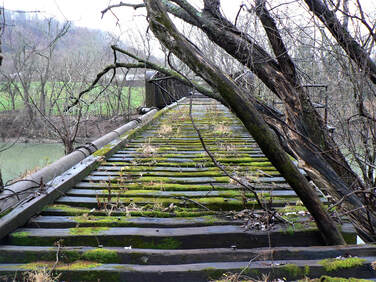
Left: The abandoned B&O girder plate bridge across the Guyandotte River. The last train to pass over this structure was in 1965. Right: Ties and planking remain on the deck--as are spikes--indicating that only the rails are removed. Note the water pipe on the side which explains why the structure was left intact. Dan Robie 2020
|
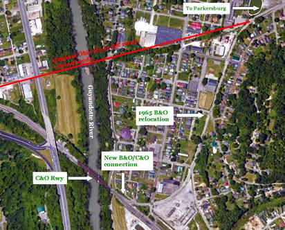
Google Earth view at Guyandotte highlighting the former railroad right of way entrance into Huntington. The 1965 relocation of the B&O/C&O connection as it is in its current state is visible.
|
The original Ohio River Railroad paralleled the C&O for a short distance once in Huntington. At the C&O Shops, the route turned north heading for the inner city.
|
1904 Sanborn map key and cover page for Huntington. Indicated here is the Ohio River Railroad route through the city extending towards Ceredo. The C&O main line and Belt Line trackage are also visible in a simplified railroad reference.
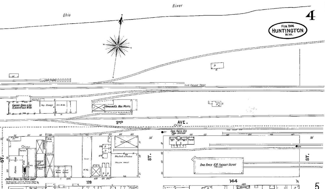
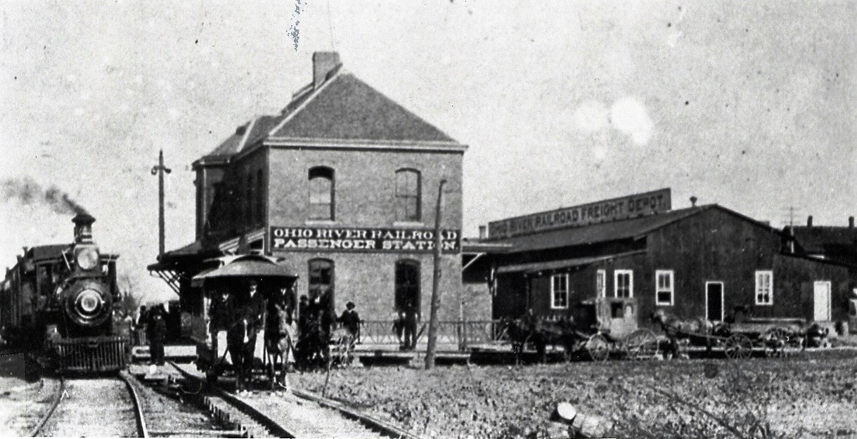
The heart of the Ohio River Railroad and later B&O in Huntington was along 2nd Avenue where both the passenger and freight stations were located. It lay in the downtown area flanked by industrial and warehouse districts. So concentrated was commerce at Huntington that if one also includes the industrial pockets to the east near Guyandotte, the list of shippers still in existence after World War II was impressive. In fact, in terms of sheer quantity of shippers, it was the bellwether of the B&O Ohio River line. The list of active shippers served by B&O (many jointly with C&O) in 1948 reads as:
East of station: 31st Street Team Track, Elk Refining Company, Standard Ultramarine Company, West Virginia State Road Commission, American Car and Foundry, Huntington Furniture Corporation, Penn Table Company, Davis Wholesale Grocery Company, Carolina Lumber Company, Abrahams & Company, McGuire Scrap Company, James J. Weller & Sons, McGinnis Company, Sam Beswick, West Virginia Rail Company, Early and Daniels Company, Foster-Thornburg Hardware, Grocers Wholesale Company, Freight Station Team Tracks, Christian Company, Midland Storage Company, and the Harold T. Christian Company.
West of station: Emmons-Hawkins Hardware, Hagen, Ratlcliff and Company, Southern Wholesale Furniture Company, Armour & Company, Gwinn Brothers Company, Southern States Cooperative, Thomas O’Neill Machine Shop, Riverside Paper Company, West Virginia Seating Company, Huntington Paper & China Company, Tri-State Appliance Company, Goodman Manufacturing Company, Banks-Miller Supply Company, 5th Street Team Track, E. Layne (Livestock), Minter Homes Corporation, Huntington Boiler Works Company, H. J Heinz Company, M. Cohan & Company, Logan Hardware& Supply Company, Spur Distributing Company, Ohio Valley Bus Company, and the Interstate Upholstery Company.
15th Street Industrial Track: Duncan Box & Lumber Company, National Steel Products Company, Feisenmeier Packing Company, W. W Payne, Gissel Packing Company, South Penn Oil Company, Ackerman Lumber & Manufacturing Company, and the Wood-Mosaic Poplar Veneer Company.
1904 Sanborn map of the 2nd Avenue district that includes both the Ohio River Railroad freight and passenger stations. Also shown are shippers in the neighborhood and the C&O Belt Line/River Yard area along the Ohio River.
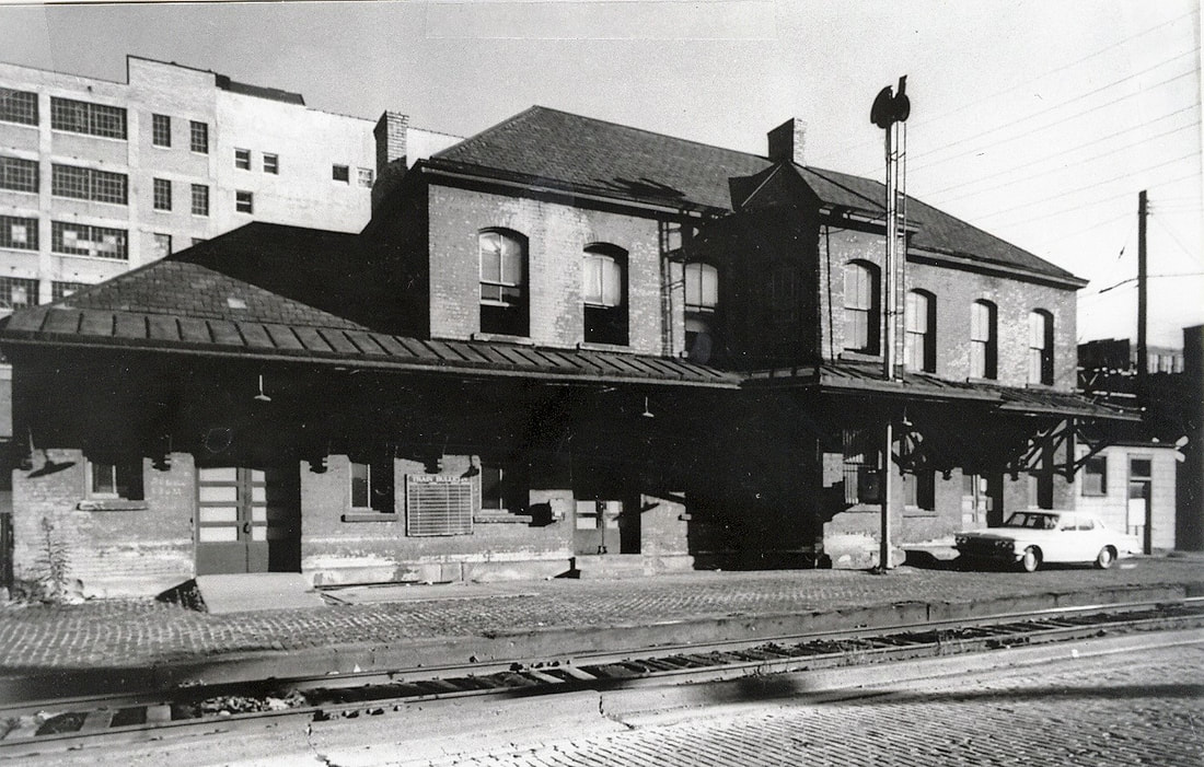
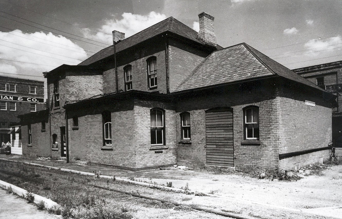
Owing to its size and location, Huntington was obviously a primary passenger station along the Ohio River Railroad extending deep into the B&O era. It was an origination and termination point for the traveler to and from Point Pleasant, Parkersburg, and Wheeling and, of course, points in between and beyond. Servicing facilities were scattered at different locations within Huntington. Water and a track scale were located at 19th Street and a coaling tower at the Huntington station--- which was assigned with the telegraph call letters HU. In West Huntington, a livestock facility was located at E. Layne near the C&O Belt Line crossing.
|
Early Ohio River Railroad scene at the Huntington passenger station during the 1890s. Note the freight station directly behind. Image John G.King/Dan Robie collection
|
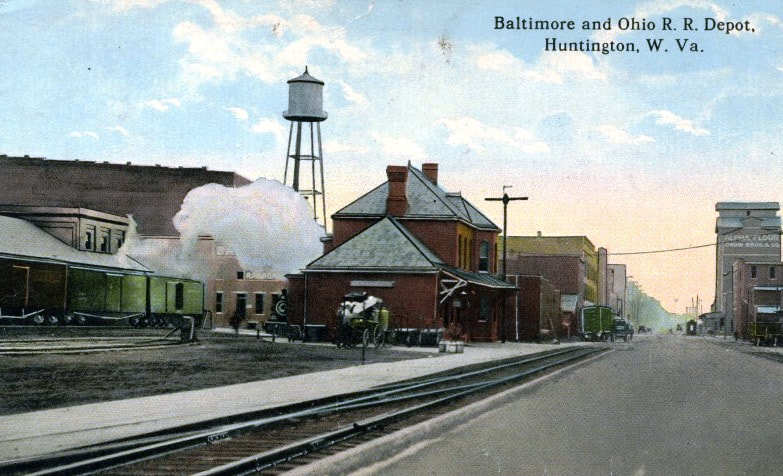
Looking along 2nd Avenue at both depots as they appeared circa 1920. A bustling commercial district of Huntington for many years. Image West Virginia and Regional History
|
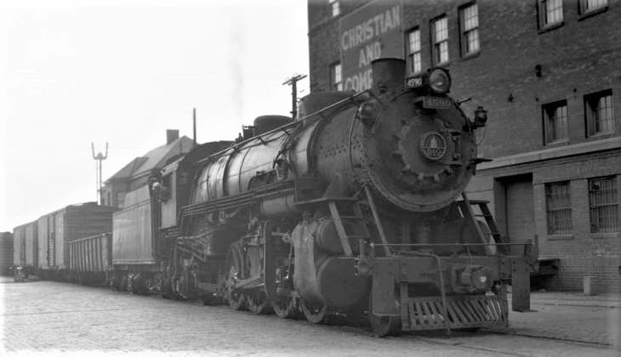
Street running on 2nd Avenue in 1951. B&O 2-8-2 #4590 leads a mixed freight train westbound through the heart of the old industrial district in downtown Huntington. The B&O station is partially visible behind the train at left. Photo Otto Perry/Denver Public Library
When the C&O acquired a controlling interest in the B&O during 1963, the end of the original Ohio River Railroad main through Huntington west to Kenova was imminent. Among the first actions of a consolidated B&O/C&O system at Huntington was the abandonment and removal of the now redundant B&O trackage from Guyandotte to Kenova. This project took place in 1965 and nearly all of the former B&O was removed except for sections that served shippers exclusively located on the line. A new tract of right of way was acquired at Guyandotte to construct a relocated connection to the C&O main line which became the termination point of the Ohio River line. Fortunately, the Huntington passenger station was saved and renovated to what is known as Heritage Station.
The glory years of passenger trains were a memory when these 1964 photos were taken showing both the front and rear of the station. Soon the railroad itself would disappear into history. Both images John G. King/Dan Robie collection
Acclaimed West Virginia railroad historian and author Bob Withers documented the consolidation project in 1965 and the photos—in addition to other B&O, C&O, and N&W period images--- appear in his book Trackside Around West Virginia 1963-1968 published by Morning Sun in 2006. Copies of this book are still available.
Ceredo and Kenova
The extreme west end of the Ohio River Railroad (green)is depicted on this early 1900s topo map of the Ceredo and Kenova area. Completed as an extension from Huntington in 1893, the railroad connected with the Norfolk and Western Railway (yellow) at Kenova. This section of what became B&O was abandoned in 1965 as a C&O (orange)/B&O consolidation in the Huntington area. Students of Norfolk and Western Railway history will notice the N&W main line south of Kenova paralleled Twelvepole Creek at this time.
The former B&O deck bridge spanning Twelvepole Creek at Ceredo. Although no trains have crossed it in more than a half century it has remained useful as a bridge for utility piping. Dan Robie 2020
Two right of way views of the B&O right of way parallel to US Highway 60 in Ceredo. The trees mark and are growing on the roadbed--their size is a testament to how long the track has been gone. Dan Robie 2020
When the Ohio River Railroad undertook its final expansion--by lease and ultimately, acquisition, from Huntington to Kenova, it was basically for two reasons. First, to interchange with the Norfolk and Western Railway for a connection to the markets it served. Another was for connecting passenger service to and from the Chesapeake and Ohio Railway and the aforementioned N&W. Near the end of the line a wye was constructed to turn the steam locomotives for the return east as well as coaling and water. Tracks paralleling to C&O were used for interchange traffic and to access the union station located at Kenova. This structure, located where the N&W passed directly overhead of the C&O and B&O on its Ohio River bridge approach, was a two story affair. The lower level served B&O and C&O passengers whereas the upper level was for N&W patrons. My father switched trains here on two notable occasions--when he left for the war in early 1942 and his return nearly four years later.
|
Kenova during the golden era of passenger train travel. Train #714 prepares to depart on its long journey to Wheeling in 1916. Image B&O Magazine
A look at the upper level of the Kenova station circa 1920. An N&W train is paused for a passenger stop before continuing south. Image West Virginia and Regional History
|
The railroad west of Huntington passing through Ceredo and terminating at Kenova was completed during 1893. In reality, it functioned merely as an interchange track and a connection for passengers as no industry of record was served in this section. For nearly 70 years, passenger trains operated between Huntington and Kenova as Ohio River Railroad and later B&O trains beginning or terminating the long trip along the Ohio River. Ironically, with the demise of steam locomotives and passenger trains by the end of the 1950s, the Kenova extension was no longer necessary. When the operational consolidation of the C&O and B&O in the Huntington area commenced in 1963, the extension to Kenova was expendable. With independent B&O connections and interchanges now considered redundant, the track through Ceredo and Kenova was removed in the 1965 consolidation project. Thus ended the physical presence of the Ohio River Railroad and subsequent B&O years at its extreme west end. As railroad prominent as the Huntington-Kenova region has been both commercially and for the rail enthusiast, the pre 1963 era increased its allure all the more.
|
Google Earth view of the layout at Ceredo and Kenova. The Ohio River Railroad moved from Huntington into Ceredo and paralleled Twelvepole Creek into Kenova. From there it was adjacent to the C&O main line to the station area. The relationship of the Ohio River Railroad/B&O to the C&O and N&W here was for interchange of freight and passenger train connections.
Few telltales remain at Kenova today of the former B&O presence unless one looks for clues. Modern day railfans and photographers at Kenova watching present day CSX and NS--- not versed in the area history--- could spend a day at the location oblivious that a third railroad existed here.
|
A mid 1950s scene at Kenova that captures transition and portents of change on the horizon. The twilight of B&O steam power occupies its yard tracks as a westbound C&O coal train with a GP9/GP7 power consist passes by. In less than a decade, the two railroads would be a combined operational entity but retaining their individual identities. Image John G.King/Dan Robie collection
|
A contemporary view looking westbound along the C&O and the former B&O right of way which was located at right. The N&W Ohio River bridge passes overhead and the tree marks the spot of where the Kenova union station once stood on the opposite side of the bridge. Image Jonathan Spurlock
|
Transformations
For more than 130 years, this railroad paralleling the Ohio River for the majority of its length in West Virginia has continued to survive. First depending on predominately an agrarian culture of which it traversed, it evolved to serve the heavy industry that built along its rails during the early 20th century in centers such as Wheeling, Parkersburg, and Huntington. After the World War II years, newer technologically advanced industries –primarily chemicals-- located to areas once plowed by farmers. And that diversification is why the route has survived. Once agriculture faded, the smokestack industry compensated and eclipsed the loss. When those smokestack industries subsided, the modern production plants continued to generate carloads along the line. Supplementing these shippers is the recent surge of sand fracking and related facilities that has evolved on the eastern end of the route.
If one were to select a decade when the Ohio River line reached its peak, the 1950s would arguably be the time period. Discounting the fading of passenger trains, this would be the era of the greatest number of carloads. The older industries—oil, steel, and glass--- were still thriving. Post war development with newer plants had occurred at Natrium, Willow Island, Washington, and Ravenswood. Power plants had been constructed along the river and B&O still directly served the large market of Huntington. The only region not yet established industrially was between Point Pleasant and Huntington.
In 2017, the line remains healthy due to large shippers along the route. A couple of years ago, CSX stated that the Ohio River Subdivision was among several lines that had witnessed an increase in carloads. Whether this can be sustained is a question for a soothsayer as these are turbulent times—both for industry and the railroad. Only time will tell and record the developments that will affect the long term future of the railroad.
Credits
My gratitude to the following individual and organizational sources that made this effort possible:
Todd M. Atkinson
Baltimore and Ohio Railroad Historical Society
Marty Bernard
F. Douglas Bess, Jr.
B&O Magazine
"B&O Power" by Lawrence W. Sagle
Adam Burns
Richard J. Cook/Allen County Museum
Stephen Cooper
Chris DellaMea
Fenton Art Glass Company
Bill Gawthrop
Huntington Herald-Dispatch
ICC Archives
Jackson Herald
John P. Killoran/Bob Withers collection
Marshall County GenWeb
Mason County Historical and Preservation Society
Ohio County Public Library
Otto Perry/Denver Public Library
Pleasants County GenWeb
Rails And Trails.com
Curtis Riffle
Matt Robie
Gary W. Schlert
Howard Speidel
Jonathan Spurlock
Surface Transportation Board
Steven Titchenal
Tyler County GenWeb
Karl Underwood/Todd M. Atkinson collection
Byrne Waterman
West Virginia Geological Surveys
West Virginia and Regional History
Williamstown Historical Group
Bob Withers
J. J. Young Photo Collection/West Virginia Division of History and Culture
An acknowledgement of the highest order here to my friend Todd M. Atkinson for his contribution of personal and collection photographs of which grace this piece.
This effort is dedicated to the memory of my friend, the late John G. King, of whom without, this page would not be possible. An avid B&O historian, John's passion was to share his interest with others. This page---as with all on this site--- attempt to continue the favor as he would wish.
